1920 Map of Covelo
USGS Topo · Published 1920About this map
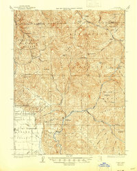
The Eel River winds through this mountainous terrain, flanked by the engineering feat of the Northwestern Pacific Railroad during the early twentieth century. This military-grade survey, updated with rail data in 1918, reveals a landscape defined by isolated family settlements and railroad infrastructure. Scattered homesteads such as Fred Simmerly Sr, John Simmerly, and Fred Robinson are documented along the river's course, providing specific genealogical data points for researchers. The presence of numerous Tunnel sites along the tracks underscores the difficulty of traversing the steep canyon walls near Spy Rock and Shell Rock. To the west, the elevation rises sharply toward Iron Peak and White Rock, while northern outposts like Bell Springs and Ramsey serve as lonely landmarks above the river’s confluence with the North Fork Eel R.
Find a feature on this map
22 named features on this map. Tap any name to fly to it.
Don’t see what you’re looking for? This feature index may not catch every label — zoom into the map to look around manually.
Map Details
Editions of this 1920 Covelo Map
This is the sole edition of this map. No revisions or reprints were ever made.
Historical Maps of Covelo Through Time
4 maps found