
1920 Map of Harris
USGS Topo · Published 1920About this map
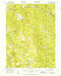
The Northwestern Pacific Railroad snakes alongside the Eel River in this 1916 survey, showcasing a rugged transportation corridor through the northern California backcountry. This era of development is highlighted by the presence of the Steelhead US Fish Hatchery near Fort Seward, reflecting early 20th-century conservation and industrial efforts in the region. The map reveals a landscape defined by isolated homesteads and livestock operations, such as Carey Ranch, Tuttles Ranch, and Scott Farm, which are connected by primitive trails and the lifeblood of the river canyon.
Find a feature on this map
33 named features on this map. Tap any name to fly to it.
Don’t see what you’re looking for? This feature index may not catch every label — zoom into the map to look around manually.
Map Details
Editions of this 1920 Harris Map
This is the sole edition of this map. No revisions or reprints were ever made.
Other maps of this area

1918 · Anada
USGS Topo · 1:62,500

1920 · Cummings
USGS Topo · 1:62,500

1920 · Covelo
USGS Topo · 1:62,500

1921 · Dyerville
USGS Topo · 1:62,500

1921 · Briceland
USGS Topo · 1:62,500

1921 · Hoaglin
USGS Topo · 1:62,500

1922 · Island Mountain
USGS Topo · 1:62,500

1931 · Hoaglin
USGS Topo · 1:96,000

1935 · Hoaglin
USGS Topo · 1:125,000
1949 · Blocksburg
USGS Topo · 1:62,500