
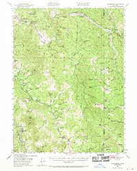
1949 Map of Blocksburg
USGS Topo · Published 1955About this map
Blocksburg serves as a central point of settlement in this 1949 survey of the California Coast Ranges, located just east of the Northwestern Pacific railroad corridor. The landscape is defined by the high divides between the Van Duzen River and the Eel River, where scattered family holdings like Gunlock Ranch, Cottrell Ranch, and Brightman Ranch occupy the plateaus and river valleys. The presence of the Buck Mtn School and the Mad River Ranger Sta indicates a community deeply integrated with the surrounding Six Rivers National Forest.
Find a feature on this map
82 named features on this map. Tap any name to fly to it.
Don’t see what you’re looking for? This feature index may not catch every label — zoom into the map to look around manually.
Map Details
Editions of this 1949 Blocksburg Map
2 editions found
Other maps of this area

1909 · Big Bar
USGS Topo · 1:96,000

1914 · Pilot Creek
USGS Topo · 1:62,500

1915 · Big Bar and Vicinity
USGS Topo · 1:250,000

1918 · Anada
USGS Topo · 1:62,500

1920 · Harris
USGS Topo · 1:62,500

1921 · Dyerville
USGS Topo · 1:62,500

1921 · Briceland
USGS Topo · 1:62,500

1921 · Hoaglin
USGS Topo · 1:62,500

1922 · Island Mountain
USGS Topo · 1:62,500

1922 · Kneeland
USGS Topo · 1:62,500