
1909 Map of Big Bar
USGS Topo · Published 1909About this map
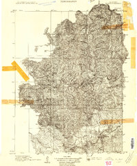
Hyampom and Hayfork stand as the primary centers of human activity in this Northern California wilderness surveyed shortly after the turn of the century. The drainage of the Trinity River and its major tributary, Hayfork Creek, dictates the movement across the landscape, with high-elevation landmarks such as Thompson Peak and Ironsides Mtn providing navigational anchors. This advance sheet, produced under the direction of George Otis Smith, focuses on the extreme relief of the region, where narrow canyons and steep ridgelines separate small mountain communities. The mapping of Keystone Meadows and various named drainages like Don Juan Creek suggests a period when local knowledge of water sources and summer grazing lands was essential for survival and commerce in Trinity County.
Find a feature on this map
27 named features on this map. Tap any name to fly to it.
Don’t see what you’re looking for? This feature index may not catch every label — zoom into the map to look around manually.
Map Details
Editions of this 1909 Big Bar Map
2 editions found
Other maps of this area

1886 · Shasta
USGS Topo · 1:250,000

1890 · Red Bluff
USGS Topo · 1:250,000

1894 · Red Bluff
USGS Topo · 1:250,000

1894 · Shasta
USGS Topo · 1:250,000

1913 · Weaverville
USGS Topo · 1:125,000

1914 · Pilot Creek
USGS Topo · 1:62,500

1915 · Big Bar and Vicinity
USGS Topo · 1:250,000

1918 · Anada
USGS Topo · 1:62,500

1922 · China Flat
USGS Topo · 1:62,500

1923 · Sawyers Bar
USGS Topo · 1:125,000