Old Maps of Hearst, California for Hiking & Exploration
Hike through history with 11 historic maps of Hearst. Explore old trails, ghost towns, and forgotten backroads — perfect for outdoor adventurers and local explorers.
- Rediscover forgotten places: Map out old mining camps, roads, and footpaths that no longer exist on modern maps.
- Layer with modern tools: Combine with LiDAR or satellite views to plan hikes through historical terrain.
- Made for exploration: Popular among hikers, overlanders, and local history lovers.
Use these maps to find adventure and explore the hidden past of Hearst.
Hearst, CA maps
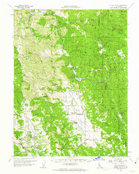
(11)- 1943 Map of Pomo, 1954 Print
 1943 Pomo1954 Print · USGSMendocino County's ranching and irrigation landscapes are captured here during the 1940s, showcasing the development of Potter Valley. Genealogists and historians can locate family lands like Mewhinney Ranch alongside the Pomo Indian Reservation and the Emandale Resort.
 - 1957 Map of Ukiah, 1966 Print
 1957 Ukiah1966 Print · USGSNorthern California's diverse terrain comes into focus in the mid-1950s, from the rugged timberlands of the Jackson State Forest to the productive Sacramento Valley. Genealogists and historians can trace the rail lines of the Northwestern Pacific or locate early valley settlements like Arbuckle and Paskenta.3 unique versions available
 - 1960 Map of Ukiah
 1960 Ukiah1960 Print · USGSNorthern California during the late fifties reveals a landscape of deep timber forests and valley agriculture before modern expansion. Trace the historic rail lines of the California Western RR and the Northwestern Pacific RR through settlements like Fort Bragg and Ukiah.2 unique versions available
 - 1960 Map of Potter Valley, 1962 Print
 1960 Potter Valley1962 Print · USGSMendocino County's agricultural and river landscapes are captured here during the early sixties, showing the vital connections between the Eel and Russian River watersheds. Genealogists and local historians can trace family roots through the Potter Valley Rancheria, the Potter Valley Cem, and old settlements like Hearst and Pomo.2 unique versions available
 - 1981 Map of Ukiah
 1981 Ukiah1981 Print · USGSMendocino County’s timber and rail landscape is captured here in the early eighties, from the coastal lumber mills to the inland valleys. Trace the California Western Railroad and find settlements like Fort Bragg, Comptche, and Navarro.3 unique versions available
 - 1991 Map of Foster Mountain
 1991 Foster Mountain1991 Print · USGSMendocino County in the early 1990s reveals a landscape of high ridges and protected river corridors. Researchers can locate the Hearst (Site), the Emandal Resort, and the boundaries of the Potter Valley Rancheria Indian Reservation.
 - 1996 Map of Foster Mountain, 2001 Print
 1996 Foster Mountain2001 Print · USGSMendocino County ranching culture and river life were well-established when this survey was updated in the late nineties. Genealogists and local historians can trace family properties like Soudan Ranch and Todd Ranch or find the Hearst (Site) settlement.
 - 2012 Map of Foster Mountain, 2012 Print
 2012 Foster Mountain2012 Print · USGSCovers Hearst, including Mendocino County, United States, and other nearby areas
 - 2015 Map of Foster Mountain, 2015 Print
 2015 Foster Mountain2015 Print · USGSCovers Hearst, including Mendocino County, United States, and other nearby areas
 - 2018 Map of Foster Mountain, 2018 Print
 2018 Foster Mountain2018 Print · USGSCovers Hearst, including Mendocino County, United States, and other nearby areas
 - 2021 Map of Foster Mountain, 2021 Print
 2021 Foster Mountain2021 Print · USGSMendocino County’s rugged interior is documented here in the early twenty-first century, centered on the settlement of Hearst. Local historians can trace the paths of Hearst Post Office Rd and Old Wagon Rd near Foster Mountain and the Eel Wild and Scenic River.
End of results
Showing maps 1-11 of 11
Top cities near Hearst
Frequently asked questions
- What are the different types of historical maps available for Hearst?
- What is the oldest map of Hearst?
- Where can I purchase historical maps of Hearst for my home or office?
- Where can I download high-res historical maps of Hearst?
- Are there historical topographic maps available for Hearst?
- Is there historical aerial imagery available for Hearst?
- Where are historical maps of Hearst sourced from?