1940s Maps of Irish Beach, California
Explore 2 historic maps of Irish Beach from the 1940s. These maps offer a rare glimpse into what life looked like during the 1940s — showing old roads, neighborhoods, homes, and landmarks that have changed or disappeared over time.
Whether you're researching your family's past, planning a metal detecting trip, or studying how Irish Beach's landscape evolved across the 1940s, these high-resolution maps are a powerful tool for exploring the history of this region.
- Focus on a specific era: All maps on this page are from the 1940s, giving you a focused view of this time period.
- See what’s changed: Compare century-old streets, trails, and buildings to today's modern landscape using overlays and satellite layers.
- Research with precision: Use these maps for genealogy, historical research, land use analysis, or educational projects.
- View, download, or print: Maps are fully viewable online in high resolution, and can be downloaded or printed for your own records.
Start exploring Irish Beach's history through authentic maps from the 1940s. This is your window into the past.
Irish Beach, CA maps
(2)- 1943 Map of Navarro, 1954 Print
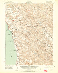 1943 Navarro1954 Print · USGSCoastal Mendocino County during the early war years reveals a rugged timber and ranching economy along the Pacific shore. Genealogists and local historians can trace family landmarks like the Galletti Ranch, small rural school sites such as Signal Sch, and maritime history at Bridgeport Landing.3 unique versions available
 - 1944 Map of Saddle Point
 1944 Saddle Point1944 Print · USGSCoastal Mendocino County is captured here in the mid-1940s, showing a landscape of maritime landings and upland ranches. Genealogists can trace family holdings like Gallatti Ranch and Williams Ranch or locate vanished rural schoolhouses such as Signal School and Hansen School.
End of results
Showing maps 1-2 of 2
Top cities near Irish Beach
Frequently asked questions
- What are the different types of historical maps available for Irish Beach?
- What is the oldest map of Irish Beach?
- Where can I purchase historical maps of Irish Beach for my home or office?
- Where can I download high-res historical maps of Irish Beach?
- Are there historical topographic maps available for Irish Beach?
- Is there historical aerial imagery available for Irish Beach?
- Where are historical maps of Irish Beach sourced from?