1940s Maps of Livingston, California
Explore 5 historic maps of Livingston from the 1940s. These maps offer a rare glimpse into what life looked like during the 1940s — showing old roads, neighborhoods, homes, and landmarks that have changed or disappeared over time.
Whether you're researching your family's past, planning a metal detecting trip, or studying how Livingston's landscape evolved across the 1940s, these high-resolution maps are a powerful tool for exploring the history of this region.
- Focus on a specific era: All maps on this page are from the 1940s, giving you a focused view of this time period.
- See what’s changed: Compare century-old streets, trails, and buildings to today's modern landscape using overlays and satellite layers.
- Research with precision: Use these maps for genealogy, historical research, land use analysis, or educational projects.
- View, download, or print: Maps are fully viewable online in high resolution, and can be downloaded or printed for your own records.
Start exploring Livingston's history through authentic maps from the 1940s. This is your window into the past.
Livingston, CA maps
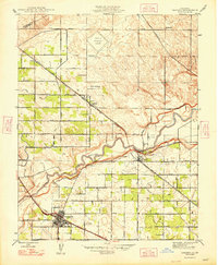
(5)- 1942 Map of Irwin
 1942 Irwin1942 Print · USGSThe San Joaquin and Merced rivers dominate this 1940s landscape where early irrigation networks met established rail lines. Genealogists can trace rural school districts like Tegner Sch and Helmar Sch or locate old river crossings at Hills Ferry and Fremont Ford.
 - 1947 Map of San Jose, 1948 Print
 1947 San Jose1948 Print · USGSNorthern California's heartland is captured here just after the war, showing the rapid growth of the Santa Clara and Central Valleys. Researchers can trace the legacy of rail and water at Castle Air Force Base, Stockton, and the Hetch Hetchy Aqueduct.
 - 1948 Map of Arena
 1948 Arena1948 Print · USGSAgricultural Merced County comes into sharp focus in the late 1940s, showing the precise grid of irrigation and transport that fueled the Central Valley. Researchers can trace historic property boundaries along family-named roads like McGinley Lateral and locate local landmarks such as Arena Sch and Jordan Sch.
 - 1948 Map of Cressey
 1948 Cressey1948 Print · USGSMerced County agriculture and rail transit are at their post-war peak in this detailed mid-century survey. Genealogists and local historians can trace family properties like the Silver Ann Ranch or locate the old Fruitland Sch and Barfield Sch.2 unique versions available
 - 1948 Map of Turlock
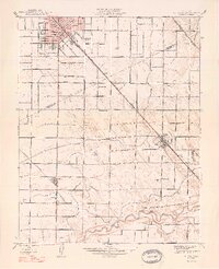 1948 Turlock1948 Print · USGSThe San Joaquin Valley's agricultural heartland thrives in the late 1940s, showcasing the intricate irrigation and rail systems that supported its growth. Researchers can trace the rural school system at Roselawn Sch and Elim Sch or locate family footprints near Fairmead Farm and Delhi.2 unique versions available
End of results
Showing maps 1-5 of 5
Top cities near Livingston
- Modesto historical maps
- Merced historical maps
- Turlock historical maps
- Ceres historical maps
- Atwater historical maps
- Delhi historical maps
See more
Frequently asked questions
- What are the different types of historical maps available for Livingston?
- What is the oldest map of Livingston?
- Where can I purchase historical maps of Livingston for my home or office?
- Where can I download high-res historical maps of Livingston?
- Are there historical topographic maps available for Livingston?
- Is there historical aerial imagery available for Livingston?
- Where are historical maps of Livingston sourced from?