1900s (20th Century) Maps of Newell, California
Explore 8 historic maps of Newell from the 1900s (20th Century). These maps offer a rare glimpse into what life looked like during the 1900s — showing old roads, neighborhoods, homes, and landmarks that have changed or disappeared over time.
Whether you're researching your family's past, planning a metal detecting trip, or studying how Newell's landscape evolved across the 1900s, these high-resolution maps are a powerful tool for exploring the history of this region.
- Focus on a specific era: All maps on this page are from the 1900s, giving you a focused view of this time period.
- See what’s changed: Compare century-old streets, trails, and buildings to today's modern landscape using overlays and satellite layers.
- Research with precision: Use these maps for genealogy, historical research, land use analysis, or educational projects.
- View, download, or print: Maps are fully viewable online in high resolution, and can be downloaded or printed for your own records.
Start exploring Newell's history through authentic maps from the 1900s. This is your window into the past.
Newell, CA maps
(8)- 1951 Map of Tulelake, 1953 Print
 1951 Tulelake1953 Print · USGSTule Lake and the Modoc plateau are captured in the early fifties during the height of the region's agricultural development. Genealogists and historians can trace the legacy of family ranching at Old Elliot Ranch or locate the historic Battle of Lands Ranch (Site) and Carr School.4 unique versions available
 - 1954 Map of Alturas, 1968 Print
 1954 Alturas1968 Print · USGSThe Modoc Plateau and Surprise Valley appear in the mid-1950s as a landscape of remote ranching towns and vast wildlife refuges. Researchers can trace early settlements like Fort Bidwell, locate the McArthur Grain Elevator, and follow the Southern Pacific rail lines.4 unique versions available
 - 1958 Map of Alturas
 1958 Alturas1958 Print · USGSThe Modoc Plateau and Warner Mountains appear here during the late fifties, showcasing a landscape of high-desert ranching and volcanic terrain. Researchers can trace the rail-and-water economy through Alturas, Cedarville, and the Fort Bidwell Indian Res.2 unique versions available
 - 1962 Map of Alturas
 1962 Alturas1962 Print · USGSThe high desert of Modoc and Siskiyou counties is shown in the early sixties as a hub of timber, rail, and agriculture. Genealogists and historians can trace rail-side life via the Southern Pacific RR, the Tionesta PO, and the McArthur Grain Elevator.
 - 1965 Map of Alturas
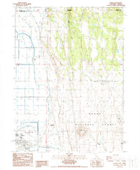
 1965 Alturas1965 Print · USGSNortheastern California and southern Oregon appear in this mid-century survey of the high plateau and volcanic highlands. Researchers can trace the path of the Southern Pacific railroad through Alturas or locate rural outposts like Stronghold and Eagleville.
 - 1984 Map of Tulelake, 1985 Print
 1984 Tulelake1985 Print · USGSThe high desert and volcanic basins of the California-Oregon border are captured here in the mid-eighties. Researchers can trace the legacy of the Southern Pacific railroad through settlements like Stronghold, Newell, and the sprawling Lava Beds National Monument.2 unique versions available
 - 1988 Map of Newell
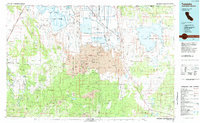
 1988 Newell1988 Print · USGSThe high-desert borderlands of Modoc County are captured here in the late eighties, showing the intersection of heavy reclamation and ranching. Genealogists and historians can locate family holdings like Old Elliot Ranch and Mike Faine Ranch near the Tulelake Airport.
 - 1993 Map of Newell, 1996 Print
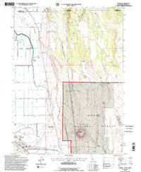 1993 Newell1996 Print · USGSNear the California-Oregon border in the early nineties, this area showcases the intersection of federal forest land and high-desert agriculture. Researchers can locate family-named sites like the Mike Faine Ranch and Jim Horn Ranch or trace the irrigation works around Newell.2 unique versions available
End of results
Showing maps 1-8 of 8
Top cities near Newell
Frequently asked questions
- What are the different types of historical maps available for Newell?
- What is the oldest map of Newell?
- Where can I purchase historical maps of Newell for my home or office?
- Where can I download high-res historical maps of Newell?
- Are there historical topographic maps available for Newell?
- Is there historical aerial imagery available for Newell?
- Where are historical maps of Newell sourced from?