Old Maps of Bennettville, California for Metal Detecting
Plan your next treasure hunt with 14 historic maps of Bennettville. Find old homesites, ghost towns, trails, and gathering spots that may be lost to time — perfect for identifying promising metal detecting locations.
- Locate forgotten sites: Uncover places like long-lost settlements, abandoned rail lines, or gathering spots.
- Plan better hunts: Use map overlays combined with LiDAR or satellite views to narrow in on historically rich areas.
- Made for detectorists: Thousands of hobbyists use these maps to discover relics, coins, and hidden history.
Use these historic maps to boost your research and find new opportunities beneath the surface of Bennettville.
Bennettville, CA maps
(14)- 1901 Map of Mt. Lyell
 1901 Mt. Lyell1901 Print · USGSThe High Sierra at the end of the century is captured here in immense detail, showing the early boundaries of Yosemite National Park. Researchers can trace old mountain routes past Soda Springs, Tuolumne Meadows, and Miller Bridge.12 unique versions available
 - 1947 Map of Mariposa, 1948 Print
 1947 Mariposa1948 Print · USGSThe High Sierra and Owens Valley transition is captured here in the late 1940s, just as the region’s hydroelectric and tourism infrastructure was maturing. Genealogists and historians can trace old ranger stations, the Casa Diablo Mine, and rail stops along the Southern Pacific like Benton Station and Zurich.2 unique versions available
 - 1948 Map of Mariposa, 1951 Print
 1948 Mariposa1951 Print · USGSThe High Sierra and Mariposa foothills are shown here in the late 1940s as the post-war tourism and water infrastructure expanded. Genealogists and historians can locate vanished waypoints like Mormon Bar, the Glacier Point Hotel, and the granite quarries of Knowles.
 - 1956 Map of Tuolumne Meadows, 1960 Print
 1956 Tuolumne Meadows1960 Print · USGSTuolumne County in the mid-fifties features a high-country landscape of granite domes and remote camps before the era of modern development. Researchers can trace historic backcountry sites like Parsons Memorial Lodge and the Fahntail Mine or locate early wilderness outposts at May Lake High Sierra Camp.5 unique versions available
 - 1957 Map of Mariposa, 1966 Print
 1957 Mariposa1966 Print · USGSThe High Sierra and Owens Valley appear in the mid-fifties, showing the intersection of conservation, hydroelectric power, and mountain industry. Genealogists and researchers can trace local landmarks like Yosemite Cemetery, the remote Kinsley Station, and the Pine Creek Mine.4 unique versions available
 - 1963 Map of Mariposa
 1963 Mariposa1963 Print · USGSThe High Sierra and Owens Valley meet in the early sixties, showing a landscape defined by gold-rush history and massive post-war water projects. Genealogists and researchers can trace old mining routes near Mariposa, locate the Glacier Point Hotel, and find small settlements like Coarse Gold or Knowles Junction.
 - 1976 Map of Yosemite Valley, 1994 Print
 1976 Yosemite Valley1994 Print · USGSThe High Sierra and the iconic Yosemite Valley are captured here during the 1970s, showing the primary road networks and backcountry trails of the day. Researchers can trace the layout of Yosemite Village or locate historic mining sites like Schroeder Mine and Buffalo Mine.2 unique versions available
 - 1990 Map of Tioga Pass
 1990 Tioga Pass1990 Print · USGSThe high Sierra crest at the close of the twentieth century shows a landscape of alpine research, recreation, and mining history. Trace the trails leading to the Great Sierra Mine, explore the waters of Saddlebag Lake, or locate the Carnegie Institute Experimental Station.
 - 1992 Map of Tioga Pass, 1995 Print
 1992 Tioga Pass1995 Print · USGSThe high Sierra crest at the opening of the 1990s reveals a landscape of scientific research and historic mountaineering. Researchers can locate the Great Sierra Mine, the Carnegie Institute Experimental Station, and the landmark Parsons Memorial Lodge near Soda Springs.
 - 1994 Map of Tioga Pass, 1997 Print
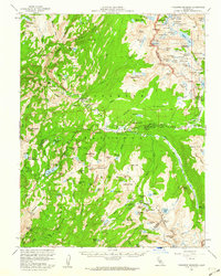
 1994 Tioga Pass1997 Print · USGSThe high Sierra landscape near the Tuolumne and Mono county line is captured here in the mid-nineties. Researchers and genealogists can trace the history of Bennettville, the Great Sierra Mine, and Tuolumne Meadows Lodge along the Tioga Road.3 unique versions available
 - 2012 Map of Tioga Pass, 2012 Print
 2012 Tioga Pass2012 Print · USGSCovers Bennettville, including Tuolumne County, Mono County, and other nearby areas
 - 2015 Map of Tioga Pass, 2015 Print
 2015 Tioga Pass2015 Print · USGSCovers Bennettville, including Tuolumne County, Mono County, and other nearby areas
 - 2018 Map of Tioga Pass, 2018 Print
 2018 Tioga Pass2018 Print · USGSCovers Bennettville, including Tuolumne County, Mono County, and other nearby areas
 - 2021 Map of Tioga Pass, 2021 Print
 2021 Tioga Pass2021 Print · USGSHigh Sierra crests and alpine lakes define this 2021 survey of the boundary between Yosemite and the Inyo National Forest. Hikers and historians can trace routes to Hess Mine Trl, summit Gaylor Peak, or navigate the shores of Saddlebag Lake.
End of results
Showing maps 1-14 of 14
Top cities near Bennettville
Frequently asked questions
- What are the different types of historical maps available for Bennettville?
- What is the oldest map of Bennettville?
- Where can I purchase historical maps of Bennettville for my home or office?
- Where can I download high-res historical maps of Bennettville?
- Are there historical topographic maps available for Bennettville?
- Is there historical aerial imagery available for Bennettville?
- Where are historical maps of Bennettville sourced from?