1990s Maps of Benton Crossing, California
Explore 2 historic maps of Benton Crossing from the 1990s. These maps offer a rare glimpse into what life looked like during the 1990s — showing old roads, neighborhoods, homes, and landmarks that have changed or disappeared over time.
Whether you're researching your family's past, planning a metal detecting trip, or studying how Benton Crossing's landscape evolved across the 1990s, these high-resolution maps are a powerful tool for exploring the history of this region.
- Focus on a specific era: All maps on this page are from the 1990s, giving you a focused view of this time period.
- See what’s changed: Compare century-old streets, trails, and buildings to today's modern landscape using overlays and satellite layers.
- Research with precision: Use these maps for genealogy, historical research, land use analysis, or educational projects.
- View, download, or print: Maps are fully viewable online in high resolution, and can be downloaded or printed for your own records.
Start exploring Benton Crossing's history through authentic maps from the 1990s. This is your window into the past.
Benton Crossing, CA maps
(2)- 1990 Map of Whitmore Hot Sprs, 1995 Print
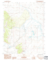 1990 Whitmore Hot Sprs1995 Print · USGSMono County's hydrothermal landscape is captured here in the early nineties, showing a region defined by its volcanic geology and high-desert hydrology. Researchers can locate the State Fish Hatchery, the isolated Cashbaugh Ranch, and the waters of Big Alkali Lake.
 - 1994 Map of Whitmore Hot Sprs, 1997 Print
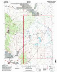 1994 Whitmore Hot Sprs1997 Print · USGSThe geothermal Long Valley region during the 1990s highlights a landscape of alkali flats and thermal springs. Genealogists and researchers can locate Cashbaugh Ranch, Whitmore Hot Sprs, and the Hot Creek State Fish Hatchery along the Owens River.
End of results
Showing maps 1-2 of 2
Top cities near Benton Crossing
- Mammoth Lakes historical maps
- Crowley Lake historical maps
- Swall Meadows historical maps
- Paradise historical maps
- Sunny Slopes historical maps
- Aspen Springs historical maps
See more
Frequently asked questions
- What are the different types of historical maps available for Benton Crossing?
- What is the oldest map of Benton Crossing?
- Where can I purchase historical maps of Benton Crossing for my home or office?
- Where can I download high-res historical maps of Benton Crossing?
- Are there historical topographic maps available for Benton Crossing?
- Is there historical aerial imagery available for Benton Crossing?
- Where are historical maps of Benton Crossing sourced from?