1950s Maps of Upper Town, California
Explore 2 historic maps of Upper Town from the 1950s. These maps offer a rare glimpse into what life looked like during the 1950s — showing old roads, neighborhoods, homes, and landmarks that have changed or disappeared over time.
Whether you're researching your family's past, planning a metal detecting trip, or studying how Upper Town's landscape evolved across the 1950s, these high-resolution maps are a powerful tool for exploring the history of this region.
- Focus on a specific era: All maps on this page are from the 1950s, giving you a focused view of this time period.
- See what’s changed: Compare century-old streets, trails, and buildings to today's modern landscape using overlays and satellite layers.
- Research with precision: Use these maps for genealogy, historical research, land use analysis, or educational projects.
- View, download, or print: Maps are fully viewable online in high resolution, and can be downloaded or printed for your own records.
Start exploring Upper Town's history through authentic maps from the 1950s. This is your window into the past.
Upper Town, CA maps
(2)- 1957 Map of Walker Lake
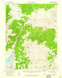
 1957 Walker Lake1957 Print · USGSThe Nevada-California borderlands in the mid-1950s show a rugged network of mining camps and river-valley towns centered around Walker Lake. Researchers can trace the Southern Pacific rail line and locate historical sites like Bodie, Sodaville, and the Leviathan Sulphur Mine.4 unique versions available
 - 1958 Map of Bridgeport, 1960 Print
 1958 Bridgeport1960 Print · USGSHigh Sierra ranching and mining legacy define the Bridgeport area in the late fifties, where the Walker River Reservoir meets the Toiyabe National Forest. Genealogists and historians can trace defunct settlements and mines like Masonic, the Chemung Mine, and Star City.4 unique versions available
End of results
Showing maps 1-2 of 2
Frequently asked questions
- What are the different types of historical maps available for Upper Town?
- What is the oldest map of Upper Town?
- Where can I purchase historical maps of Upper Town for my home or office?
- Where can I download high-res historical maps of Upper Town?
- Are there historical topographic maps available for Upper Town?
- Is there historical aerial imagery available for Upper Town?
- Where are historical maps of Upper Town sourced from?