1950s Maps of Gonzales, California
Explore 6 historic maps of Gonzales from the 1950s. These maps offer a rare glimpse into what life looked like during the 1950s — showing old roads, neighborhoods, homes, and landmarks that have changed or disappeared over time.
Whether you're researching your family's past, planning a metal detecting trip, or studying how Gonzales's landscape evolved across the 1950s, these high-resolution maps are a powerful tool for exploring the history of this region.
- Focus on a specific era: All maps on this page are from the 1950s, giving you a focused view of this time period.
- See what’s changed: Compare century-old streets, trails, and buildings to today's modern landscape using overlays and satellite layers.
- Research with precision: Use these maps for genealogy, historical research, land use analysis, or educational projects.
- View, download, or print: Maps are fully viewable online in high resolution, and can be downloaded or printed for your own records.
Start exploring Gonzales's history through authentic maps from the 1950s. This is your window into the past.
Gonzales, CA maps
(6)- 1955 Map of Santa Cruz
 1955 Santa Cruz1955 Print · USGSCoastal Monterey Bay and the fertile Salinas Valley are captured here during the post-war expansion of the mid-fifties. Researchers can trace the era's rail-and-road network via the Southern Pacific lines and find landmarks like Fort Ord or the Lonoak School.
 - 1955 Map of Gonzales, 1957 Print
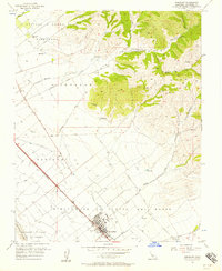 1955 Gonzales1957 Print · USGSThe Salinas Valley agricultural landscape and the foothills of the Gabilan Range are shown here during the mid-fifties. Genealogists and researchers can trace property lines through large land grants like Zanjones or locate the Southern Pacific stops at Gonzales and Penvir.4 unique versions available
 - 1956 Map of Palo Escrito Peak
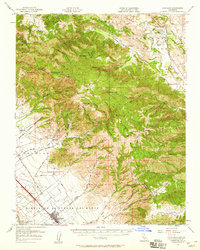
 1956 Palo Escrito Peak1956 Print · USGSMonterey County’s Salinas Valley transitions from fertile river bottoms to high peaks during the mid-fifties. Researchers can locate the Soledad State Prison, trace the Southern Pacific rail line through Molus, and find the Gonzales Cemetery.5 unique versions available
 - 1957 Map of Santa Cruz
 1957 Santa Cruz1957 Print · USGSCentral California comes into sharp focus during the late fifties, from the fog-swept Monterey Bay to the sun-drenched San Joaquin Valley. Genealogists and historians can trace the mid-century footprints of Fort Ord Military Reservation, the Southern Pacific line, and the historic streets of San Juan Bautista.
 - 1957 Map of Gonzales, 1959 Print
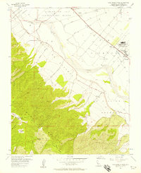
 1957 Gonzales1959 Print · USGSCoastal range ranching and Salinas Valley agriculture meet in the late 1950s near the border of Monterey and San Benito counties. Researchers can trace the rail corridor of the Southern Pacific through Gonzales or locate rural landmarks like Cienega School and Paicines Ranch.2 unique versions available
 - 1958 Map of Santa Cruz
 1958 Santa Cruz1958 Print · USGSCoastal California and the central valleys are shown during the mid-fifties, capturing a landscape of massive military reserves and vital rail arteries. Genealogists and historians can trace the Southern Pacific line through Salinas or explore the early footprints of the Fort Ord Military Reservation and San Juan Bautista.2 unique versions available
End of results
Showing maps 1-6 of 6
Top cities near Gonzales
Frequently asked questions
- What are the different types of historical maps available for Gonzales?
- What is the oldest map of Gonzales?
- Where can I purchase historical maps of Gonzales for my home or office?
- Where can I download high-res historical maps of Gonzales?
- Are there historical topographic maps available for Gonzales?
- Is there historical aerial imagery available for Gonzales?
- Where are historical maps of Gonzales sourced from?