1940s Maps of Marina, California
Explore 8 historic maps of Marina from the 1940s. These maps offer a rare glimpse into what life looked like during the 1940s — showing old roads, neighborhoods, homes, and landmarks that have changed or disappeared over time.
Whether you're researching your family's past, planning a metal detecting trip, or studying how Marina's landscape evolved across the 1940s, these high-resolution maps are a powerful tool for exploring the history of this region.
- Focus on a specific era: All maps on this page are from the 1940s, giving you a focused view of this time period.
- See what’s changed: Compare century-old streets, trails, and buildings to today's modern landscape using overlays and satellite layers.
- Research with precision: Use these maps for genealogy, historical research, land use analysis, or educational projects.
- View, download, or print: Maps are fully viewable online in high resolution, and can be downloaded or printed for your own records.
Start exploring Marina's history through authentic maps from the 1940s. This is your window into the past.
Marina, CA maps
(8)- 1940 Map of Salinas
 1940 Salinas1940 Print · USGSThe Salinas Valley at the start of the 1940s shows an agricultural landscape defined by historic land grants and expanding industry. Researchers can trace rural school locations like Natividad School and established landmarks such as Hartnell College and the railroad hub at Spreckles.
 - 1941 Map of Monterey
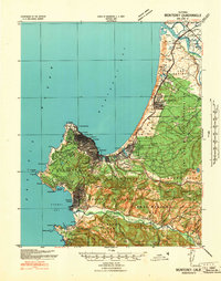 1941 Monterey1941 Print · USGSThe Monterey Peninsula and Salinas Valley appear here just before the massive wartime expansion of the early forties. You can trace the famous Seventeen Mile Drive, the early footprint of Camp Ord, and local family landmarks like Rincon Sch and Nashua.
 - 1947 Map of Salinas, 1948 Print
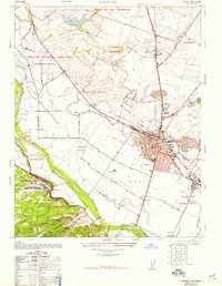 1947 Salinas1948 Print · USGSSalinas and the fertile Monterey County floor are shown in the late 1940s as the region transitioned from a wartime military hub to an agricultural powerhouse. Genealogists and local historians can trace family-named ranches like Clausens Ranch and landmark schools such as Blanco School or the Junior College.7 unique versions available
 - 1947 Map of Monterey, 1956 Print
 1947 Monterey1956 Print · USGSThe Monterey Peninsula at the start of the Cold War era shows a heavy military presence alongside its historic coastal towns. Researchers can trace the layout of the Fort Ord Military Reservation or locate family sites near the Carmel Mission and El Carmelo Cem.4 unique versions available
 - 1947 Map of Salinas, 1957 Print
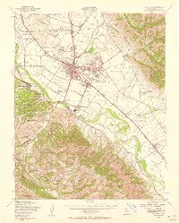 1947 Salinas1957 Print · USGSThe Salinas Valley transitions from an agricultural powerhouse to a growing urban center in the years following World War II. Researchers can locate family ranch sites and community hubs like Spreckels, Confederate Corners, and the Fort Ord Military Reservation.2 unique versions available
 - 1947 Map of Marina, 1961 Print
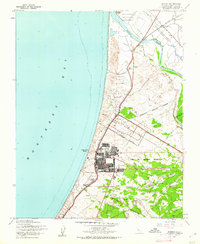 1947 Marina1961 Print · USGSThe Monterey coast after the war reveals a landscape of massive military mobilization and quiet rail sidings. Researchers can trace the layout of Fort Ord Military Reservation and find local landmarks like Rincon Sch and Gigling Siding.6 unique versions available
 - 1948 Map of Santa Cruz
 1948 Santa Cruz1948 Print · USGSThe Central Coast and San Joaquin Valley meet in this mid-century look at the region's agricultural and military geography. Genealogists and historians can trace the paths of El Camino Real, locate family farms near Hollister, or study the footprint of the Fort Ord Military Reservation.2 unique versions available
 - 1948 Map of Marina
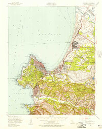
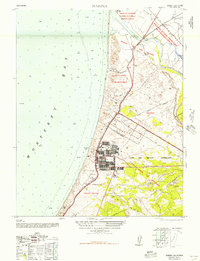 1948 Marina1948 Print · USGSCoastal Monterey County is shown in the late 1940s during the height of the military era. Genealogists and historians can trace the footprint of the Main Garrison, old railroad stops like Lapis Siding, and the early layout of Marina.
End of results
Showing maps 1-8 of 8
Top cities near Marina
- Salinas historical maps
- Watsonville historical maps
- Monterey historical maps
- Prunedale historical maps
- Pacific Grove historical maps
- Carmel-by-the-Sea historical maps
See more
Top neighborhoods of Marina
Frequently asked questions
- What are the different types of historical maps available for Marina?
- What is the oldest map of Marina?
- Where can I purchase historical maps of Marina for my home or office?
- Where can I download high-res historical maps of Marina?
- Are there historical topographic maps available for Marina?
- Is there historical aerial imagery available for Marina?
- Where are historical maps of Marina sourced from?