Old Maps of Robles Del Rio, California for Genealogy
Trace your family roots with 18 historic maps of Robles Del Rio. These high-res maps reveal old neighborhoods, homesites, landmarks, and streets — helping you uncover where your ancestors lived and how the area evolved over time.
- Explore historic neighborhoods: Identify where your relatives may have lived in the 1800s or 1900s.
- Compare maps over time: Trace the changes in streets, buildings, and landmarks for multi-generational research.
- Perfect for genealogy & ancestry research: Used by family historians and researchers to map out lineage and migration.
These maps are an incredible resource for exploring your personal connection to Robles Del Rio's past.
Robles Del Rio, CA maps
(18)- 1920 Map of Jamesburg
 1920 Jamesburg1920 Print · USGSMonterey County ranch lands and high forest peaks appear here as they were during the late teens. Genealogists and local historians can locate early homesteads and community hubs like Jamesburg, the Tularcitos Ranch, and several remote schoolhouses.
 - 1921 Map of Jamesburg
 1921 Jamesburg1921 Print · USGSCoastal mountains and remote ranchlands define this part of Monterey County in the early twenties. Researchers can trace the placement of Tularcitos School, family estates like Tularcitos Ranch, and landmarks like Uncle Sam Mtn.5 unique versions available
 - 1939 Map of Jamesburg, 1956 Print
 1939 Jamesburg1956 Print · USGSJamesburg and the surrounding Santa Lucia Range appear here just before the mid-century, capturing the era of mountain ranching and early dam construction. Researchers can locate the Tularcitos Sch, the early San Clemente Dam, and family landmarks like Bruce Ranch.2 unique versions available
 - 1940 Map of Jamesburg
 1940 Jamesburg1940 Print · USGSThe rugged Santa Lucia interior during the early 1940s is shown here through its network of remote ranching outposts and canyon settlements. Local researchers can trace family landmarks like Tularcitos Ranch, Bruce Ranch, and the isolated Tularcitos School.2 unique versions available
 - 1947 Map of Jamesburg
 1947 Jamesburg1947 Print · USGSThe Carmel River backcountry of Monterey County is captured here in the late 1940s, showcasing a landscape of high ridges and isolated ranching outposts. Researchers can trace the layout of Jamesburg, the historic Tularcitos School, and the San Clemente Dam.
 - 1948 Map of Santa Cruz
 1948 Santa Cruz1948 Print · USGSThe Central Coast and San Joaquin Valley meet in this mid-century look at the region's agricultural and military geography. Genealogists and historians can trace the paths of El Camino Real, locate family farms near Hollister, or study the footprint of the Fort Ord Military Reservation.2 unique versions available
 - 1955 Map of Santa Cruz
 1955 Santa Cruz1955 Print · USGSCoastal Monterey Bay and the fertile Salinas Valley are captured here during the post-war expansion of the mid-fifties. Researchers can trace the era's rail-and-road network via the Southern Pacific lines and find landmarks like Fort Ord or the Lonoak School.
 - 1956 Map of Carmel Valley, 1957 Print
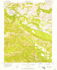 1956 Carmel Valley1957 Print · USGSMid-century Monterey County life centers on the river valley as it transitions into the forest highlands. Genealogists and local historians can trace family-named sites and rural institutions like Holman Ranch, Robles Del Rio, and the Tularcitos School.7 unique versions available
 - 1957 Map of Santa Cruz
 1957 Santa Cruz1957 Print · USGSCentral California comes into sharp focus during the late fifties, from the fog-swept Monterey Bay to the sun-drenched San Joaquin Valley. Genealogists and historians can trace the mid-century footprints of Fort Ord Military Reservation, the Southern Pacific line, and the historic streets of San Juan Bautista.
 - 1958 Map of Santa Cruz
 1958 Santa Cruz1958 Print · USGSCoastal California and the central valleys are shown during the mid-fifties, capturing a landscape of massive military reserves and vital rail arteries. Genealogists and historians can trace the Southern Pacific line through Salinas or explore the early footprints of the Fort Ord Military Reservation and San Juan Bautista.2 unique versions available
 - 1965 Map of Santa Cruz, 1968 Print
 1965 Santa Cruz1968 Print · USGSThe Central Coast and San Joaquin Valley meet here during the mid-sixties, capturing the growth of agricultural and coastal hubs. Trace the historic Southern Pacific RR lines and locate sites like the Presidio of Monterey or Pinnacles National Monument.
 - 1974 Map of Monterey, 1977 Print
 1974 Monterey1977 Print · USGSThe Central Coast and San Joaquin Valley meet in this mid-seventies survey of the Monterey region. Genealogists and historians can locate Spanish-era sites like the San Antonio de Padua Mission, early industrial markers such as the New Idria Mine, and coastal landmarks like the Point Sur Lighthouse.
 - 1982 Map of Point Sur, 1980 Print
 1982 Point Sur1980 Print · USGSCoastal mountains and fertile valleys meet in the early eighties as the Southern Pacific railroad links Monterey County's growing agricultural towns. Trace remote landmarks like Tassajara Hot Springs, the Soledad State Prison, and the sprawling Fort Hunter Liggett Military Reservation.3 unique versions available
 - 1995 Map of Carmel Valley, 2000 Print
 1995 Carmel Valley2000 Print · USGSThe Carmel River valley in the mid-1990s exhibits a unique blend of valley settlements and wild forest interior. Researchers can trace the development of Robles Del Rio and locate landmarks like Holman Ranch, the San Clemente Dam, and the Tularcitos Guard Station.
 - 2012 Map of Carmel Valley, 2012 Print
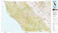
 2012 Carmel Valley2012 Print · USGSCovers Robles Del Rio, including Carmel Valley, Monterey County, and other nearby areas
 - 2015 Map of Carmel Valley, 2015 Print
 2015 Carmel Valley2015 Print · USGSCovers Robles Del Rio, including Carmel Valley, Monterey County, and other nearby areas
 - 2018 Map of Carmel Valley, 2018 Print
 2018 Carmel Valley2018 Print · USGSCovers Robles Del Rio, including Carmel Valley, Monterey County, and other nearby areas
 - 2021 Map of Carmel Valley, 2021 Print
 2021 Carmel Valley2021 Print · USGSCarmel Valley and the Santa Lucia Range are shown here in the 2020s, highlighting the area's mix of residential pockets and protected forest. Researchers can trace land development around Carmel Valley Village and Robles Del Rio or follow the many creeks that feed the Carmel River.
End of results
Showing maps 1-18 of 18
Top cities near Robles Del Rio
- Salinas historical maps
- Monterey historical maps
- Marina historical maps
- Pacific Grove historical maps
- Carmel-by-the-Sea historical maps
- Del Rey Oaks historical maps
See more
Frequently asked questions
- What are the different types of historical maps available for Robles Del Rio?
- What is the oldest map of Robles Del Rio?
- Where can I purchase historical maps of Robles Del Rio for my home or office?
- Where can I download high-res historical maps of Robles Del Rio?
- Are there historical topographic maps available for Robles Del Rio?
- Is there historical aerial imagery available for Robles Del Rio?
- Where are historical maps of Robles Del Rio sourced from?