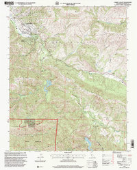
1995 Map of Carmel Valley
USGS Topo · Published 2000About this map
Carmel Valley and the community of Robles Del Rio serve as the primary human centers in this mid-1990s survey, illustrating a landscape defined by the winding course of the Carmel River. The map captures a transitional geography where residential areas and institutions like the Carmel Valley School and Tularcitos School give way to larger agricultural and pastoral holdings such as Holman Ranch and Tularcitos Ranch. Significant infrastructure manages the region's water resources, notably the San Clemente Dam and Los Padres Dam, which regulate the flow through the mountainous terrain.
Find a feature on this map
57 named features on this map. Tap any name to fly to it.
Don’t see what you’re looking for? This feature index may not catch every label — zoom into the map to look around manually.
Map Details
Editions of this 1995 Carmel Valley Map
This is the sole edition of this map. No revisions or reprints were ever made.
Other maps of this area

1910 · Salinas
USGS Topo · 1:31,680

1912 · Salinas
USGS Topo · 1:62,500

1913 · Monterey
USGS Topo · 1:62,500

1918 · Point Sur
USGS Topo · 1:62,500

1920 · Jamesburg
USGS Topo · 1:48,000

1921 · Jamesburg
USGS Topo · 1:62,500

1925 · Point Sur
USGS Topo · 1:62,500

1939 · Jamesburg
USGS Topo · 1:62,500

1940 · Salinas
USGS Topo · 1:62,500

1940 · Jamesburg
USGS Topo · 1:62,500