
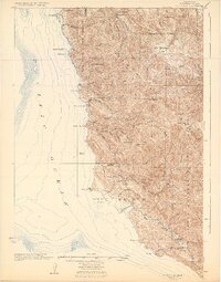
1925 Map of Point Sur
USGS Topo · Published 1925About this map
The Santa Lucia Range dominates this coastal landscape, where the rugged shoreline meets steep ridges and deep canyons surveyed just after World War I. This area of Monterey County is defined by the early ranching and maritime economy of the Big Sur coast, anchored by historical landmarks like the light station site at Point Sur and the small settlement of Big Sur near the Sur River. Early shipping activity is visible at Notleys Landing and Bixby Landing, reflecting the era when coastal schooners provided the primary link for local industries before modern road networks were fully established. Inland, family-run estates such as Corona Ranch, Molera Ranch, and San Francisquito Ranch are mapped alongside rural educational hubs like Cooper School and Majestic School. Significant peaks, including the prominent Pico Blanco and Bixby Mtn, provide clear topographic context for the drainages of the Little Sur River and numerous named canyons.
Find a feature on this map
83 named features on this map. Tap any name to fly to it.
Don’t see what you’re looking for? This feature index may not catch every label — zoom into the map to look around manually.
Map Details
Editions of this 1925 Point Sur Map
4 editions found
Historical Maps of Big Sur Village Through Time
333 maps found

1912 Metz
Monterey County, CA

1915 Priest Valley
Monterey County, CA

1918 Point Sur
Monterey County, CA

1919 Bryson
Monterey County, CA

1919 Junipero Serra
Monterey County, CA

1919 San Miguel
Monterey County, CA

1920 Jamesburg
Monterey County, CA

1921 Cape San Martin
Monterey County, CA

1921 Jamesburg
Monterey County, CA

1921 Lucia
Monterey County, CA

1921 Metz
Monterey County, CA

1925 Point Sur
Monterey County, CA

1939 Jamesburg
Monterey County, CA

1940 Jamesburg
Monterey County, CA

1940 Metz
Monterey County, CA

1941 Bryson
Monterey County, CA

1941 Cape San Martin
Monterey County, CA

1941 Junipero Serra
Monterey County, CA

1941 Lucia
Monterey County, CA

1941 Priest Valley
Monterey County, CA

1942 Bryson
Monterey County, CA

1942 Cape San Martin
Monterey County, CA

1942 Parkfield
Monterey County, CA

1943 Cholame Hills
Monterey County, CA

1943 Cholame Ranch
Monterey County, CA

1943 Parkfield
Monterey County, CA

1944 Priest Valley
Monterey County, CA

1947 Jamesburg
Monterey County, CA

1947 Lucia
Monterey County, CA

1947 Metz
Monterey County, CA

1947 Natividad
Monterey County, CA

1947 Point Sur
Monterey County, CA

1947 San Miguel
Monterey County, CA

1948 Bryson
Monterey County, CA

1948 Cape San Martin
Monterey County, CA

1948 Junipero Serra
Monterey County, CA

1948 Natividad
Monterey County, CA

1948 Ranchito Canyon
Monterey County, CA

1948 San Miguel
Monterey County, CA

1948 Stockdale Mountain
Monterey County, CA

1948 Valleton
Monterey County, CA

1949 Alder Peak
Monterey County, CA

1949 Bear Canyon
Monterey County, CA

1949 Bryson
Monterey County, CA

1949 Burnett Peak
Monterey County, CA

1949 Burro Mountain
Monterey County, CA

1949 Cape San Martin
Monterey County, CA

1949 Cone Peak
Monterey County, CA

1949 Cosio Knob
Monterey County, CA

1949 Espinosa Canyon
Monterey County, CA

1949 Hames Valley
Monterey County, CA

1949 Jolon
Monterey County, CA

1949 Junipero Serra Peak
Monterey County, CA

1949 Reliz Canyon
Monterey County, CA

1949 Thompson Canyon
Monterey County, CA

1949 Tierra Redonda Mountain
Monterey County, CA

1949 Villa Creek
Monterey County, CA

1949 Williams Hill
Monterey County, CA

1949 Wunpost
Monterey County, CA

1956 Big Sur
Monterey County, CA

1956 Carmel Valley
Monterey County, CA

1956 Chews Ridge
Monterey County, CA

1956 Lopez Point
Monterey County, CA

1956 Mt. Carmel
Monterey County, CA

1956 Palo Escrito Peak
Monterey County, CA

1956 Paraiso Springs
Monterey County, CA

1956 Partington Ridge
Monterey County, CA

1956 Pfeiffer Point
Monterey County, CA

1956 Point Sur
Monterey County, CA

1956 Priest Valley
Monterey County, CA

1956 Rana Creek
Monterey County, CA

1956 Soberanes Point
Monterey County, CA

1956 Sycamore Flat
Monterey County, CA

1956 Tassajara Hot Springs
Monterey County, CA

1956 Ventana Cones
Monterey County, CA

1961 Bryson
Monterey County, CA

1961 Cape San Martin
Monterey County, CA

1961 Cholame Hills
Monterey County, CA

1961 Cholame Valley
Monterey County, CA

1961 Junipero Serra
Monterey County, CA

1961 Parkfield
Monterey County, CA

1961 Parkfield
Monterey County, CA

1961 San Miguel
Monterey County, CA

1962 Cape San Martin
Monterey County, CA

1967 Monarch Peak
Monterey County, CA

1967 Nattrass Valley
Monterey County, CA

1967 Pancho Rico Valley
Monterey County, CA

1968 Mount Johnson
Monterey County, CA

1968 Mt. Harlan
Monterey County, CA

1969 North Chalone Peak
Monterey County, CA

1969 Pinalito Canyon
Monterey County, CA

1969 Priest Valley
Monterey County, CA

1969 Slack Canyon
Monterey County, CA

1969 Smith Mountain
Monterey County, CA

1982 Point Sur
Monterey County, CA

1995 Alder Peak
Monterey County, CA

1995 Bear Canyon
Monterey County, CA

1995 Big Sur
Monterey County, CA

1995 Burnett Peak
Monterey County, CA

1995 Burro Mountain
Monterey County, CA

1995 Cape San Martin
Monterey County, CA

1995 Carmel Valley
Monterey County, CA

1995 Chews Ridge
Monterey County, CA

1995 Cone Peak
Monterey County, CA

1995 Junipero Serra Peak
Monterey County, CA

1995 Lopez Point
Monterey County, CA

1995 Mount Carmel
Monterey County, CA

1995 North Chalone Peak
Monterey County, CA

1995 Partington Ridge
Monterey County, CA

1995 Pfeiffer Point
Monterey County, CA

1995 Reliz Canyon
Monterey County, CA

1995 Soberanes Point
Monterey County, CA

1995 Sycamore Flat
Monterey County, CA

1995 Ventana Cones
Monterey County, CA

1995 Villa Creek
Monterey County, CA

1995 Zigzag Creek
Monterey County, CA

2012 Alder Peak
Monterey County, CA

2012 Bear Canyon
Monterey County, CA

2012 Big Sur
Monterey County, CA

2012 Bryson
Monterey County, CA

2012 Burnett Peak
Monterey County, CA

2012 Burro Mountain
Monterey County, CA

2012 Cape San Martin
Monterey County, CA

2012 Cape San Martin OE W
Monterey County, CA

2012 Carmel Valley
Monterey County, CA

2012 Chews Ridge
Monterey County, CA

2012 Cholame Hills
Monterey County, CA

2012 Cholame Valley
Monterey County, CA

2012 Cone Peak
Monterey County, CA

2012 Cosio Knob
Monterey County, CA

2012 Espinosa Canyon
Monterey County, CA

2012 Hames Valley
Monterey County, CA

2012 Jolon
Monterey County, CA

2012 Junipero Serra Peak
Monterey County, CA

2012 Lopez Point
Monterey County, CA

2012 Lopez Point OE W
Monterey County, CA

2012 Monarch Peak
Monterey County, CA

2012 Monterey OE N
Monterey County, CA

2012 Mount Carmel
Monterey County, CA

2012 Mount Harlan
Monterey County, CA

2012 Mount Johnson
Monterey County, CA

2012 Natividad
Monterey County, CA

2012 Nattrass Valley
Monterey County, CA

2012 North Chalone Peak
Monterey County, CA

2012 Palo Escrito Peak
Monterey County, CA

2012 Pancho Rico Valley
Monterey County, CA

2012 Paraiso Springs
Monterey County, CA

2012 Parkfield
Monterey County, CA

2012 Partington Ridge
Monterey County, CA

2012 Pfeiffer Point
Monterey County, CA

2012 Pinalito Canyon
Monterey County, CA

2012 Point Sur
Monterey County, CA

2012 Priest Valley
Monterey County, CA

2012 Rana Creek
Monterey County, CA

2012 Ranchito Canyon
Monterey County, CA

2012 Reliz Canyon
Monterey County, CA

2012 San Miguel
Monterey County, CA

2012 Slack Canyon
Monterey County, CA

2012 Smith Mountain
Monterey County, CA

2012 Soberanes Point
Monterey County, CA

2012 Stockdale Mountain
Monterey County, CA

2012 Sycamore Flat
Monterey County, CA

2012 Thompson Canyon
Monterey County, CA

2012 Tierra Redonda Mountain
Monterey County, CA

2012 Valleton
Monterey County, CA

2012 Ventana Cones
Monterey County, CA

2012 Villa Creek
Monterey County, CA

2012 Williams Hill
Monterey County, CA

2012 Wunpost
Monterey County, CA

2012 Zigzag Creek
Monterey County, CA

2015 Alder Peak
Monterey County, CA

2015 Bear Canyon
Monterey County, CA

2015 Big Sur
Monterey County, CA

2015 Bryson
Monterey County, CA

2015 Burnett Peak
Monterey County, CA

2015 Burro Mountain
Monterey County, CA

2015 Cape San Martin
Monterey County, CA

2015 Cape San Martin OE W
Monterey County, CA

2015 Carmel Valley
Monterey County, CA

2015 Chews Ridge
Monterey County, CA

2015 Cholame Hills
Monterey County, CA

2015 Cholame Valley
Monterey County, CA

2015 Cone Peak
Monterey County, CA

2015 Cosio Knob
Monterey County, CA

2015 Espinosa Canyon
Monterey County, CA

2015 Hames Valley
Monterey County, CA

2015 Jolon
Monterey County, CA

2015 Junipero Serra Peak
Monterey County, CA

2015 Lopez Point
Monterey County, CA

2015 Lopez Point OE W
Monterey County, CA

2015 Monarch Peak
Monterey County, CA

2015 Monterey OE N
Monterey County, CA

2015 Mount Carmel
Monterey County, CA

2015 Mount Harlan
Monterey County, CA

2015 Mount Johnson
Monterey County, CA

2015 Natividad
Monterey County, CA

2015 Nattrass Valley
Monterey County, CA

2015 North Chalone Peak
Monterey County, CA

2015 Palo Escrito Peak
Monterey County, CA

2015 Pancho Rico Valley
Monterey County, CA

2015 Paraiso Springs
Monterey County, CA

2015 Parkfield
Monterey County, CA

2015 Partington Ridge
Monterey County, CA

2015 Pfeiffer Point
Monterey County, CA

2015 Pinalito Canyon
Monterey County, CA

2015 Point Sur
Monterey County, CA

2015 Priest Valley
Monterey County, CA

2015 Rana Creek
Monterey County, CA

2015 Ranchito Canyon
Monterey County, CA

2015 Reliz Canyon
Monterey County, CA

2015 San Miguel
Monterey County, CA

2015 Slack Canyon
Monterey County, CA

2015 Smith Mountain
Monterey County, CA

2015 Soberanes Point
Monterey County, CA

2015 Stockdale Mountain
Monterey County, CA

2015 Sycamore Flat
Monterey County, CA

2015 Thompson Canyon
Monterey County, CA

2015 Tierra Redonda Mountain
Monterey County, CA

2015 Valleton
Monterey County, CA

2015 Ventana Cones
Monterey County, CA

2015 Villa Creek
Monterey County, CA

2015 Williams Hill
Monterey County, CA

2015 Wunpost
Monterey County, CA

2015 Zigzag Creek
Monterey County, CA

2018 Alder Peak
Monterey County, CA

2018 Bear Canyon
Monterey County, CA

2018 Big Sur
Monterey County, CA

2018 Bryson
Monterey County, CA

2018 Burnett Peak
Monterey County, CA

2018 Burro Mountain
Monterey County, CA

2018 Cape San Martin
Monterey County, CA

2018 Cape San Martin OE W
Monterey County, CA

2018 Carmel Valley
Monterey County, CA

2018 Chews Ridge
Monterey County, CA

2018 Cholame Hills
Monterey County, CA

2018 Cholame Valley
Monterey County, CA

2018 Cone Peak
Monterey County, CA

2018 Cosio Knob
Monterey County, CA

2018 Espinosa Canyon
Monterey County, CA

2018 Hames Valley
Monterey County, CA

2018 Jolon
Monterey County, CA

2018 Junipero Serra Peak
Monterey County, CA

2018 Lopez Point
Monterey County, CA

2018 Lopez Point OE W
Monterey County, CA

2018 Monarch Peak
Monterey County, CA

2018 Monterey OE N
Monterey County, CA

2018 Mount Carmel
Monterey County, CA

2018 Mount Harlan
Monterey County, CA

2018 Mount Johnson
Monterey County, CA

2018 Natividad
Monterey County, CA

2018 Nattrass Valley
Monterey County, CA

2018 North Chalone Peak
Monterey County, CA

2018 Palo Escrito Peak
Monterey County, CA

2018 Pancho Rico Valley
Monterey County, CA

2018 Paraiso Springs
Monterey County, CA

2018 Parkfield
Monterey County, CA

2018 Partington Ridge
Monterey County, CA

2018 Pfeiffer Point
Monterey County, CA

2018 Pinalito Canyon
Monterey County, CA

2018 Point Sur
Monterey County, CA

2018 Priest Valley
Monterey County, CA

2018 Rana Creek
Monterey County, CA

2018 Ranchito Canyon
Monterey County, CA

2018 Reliz Canyon
Monterey County, CA

2018 San Miguel
Monterey County, CA

2018 Slack Canyon
Monterey County, CA

2018 Smith Mountain
Monterey County, CA

2018 Soberanes Point
Monterey County, CA

2018 Stockdale Mountain
Monterey County, CA

2018 Sycamore Flat
Monterey County, CA

2018 Thompson Canyon
Monterey County, CA

2018 Tierra Redonda Mountain
Monterey County, CA

2018 Valleton
Monterey County, CA

2018 Ventana Cones
Monterey County, CA

2018 Villa Creek
Monterey County, CA

2018 Williams Hill
Monterey County, CA

2018 Wunpost
Monterey County, CA

2018 Zigzag Creek
Monterey County, CA

2021 Alder Peak
Monterey County, CA

2021 Bear Canyon
Monterey County, CA

2021 Big Sur
Monterey County, CA

2021 Bryson
Monterey County, CA

2021 Burnett Peak
Monterey County, CA

2021 Burro Mountain
Monterey County, CA

2021 Cape San Martin
Monterey County, CA

2021 Cape San Martin OE W
Monterey County, CA

2021 Carmel Valley
Monterey County, CA

2021 Chews Ridge
Monterey County, CA

2021 Cholame Hills
Monterey County, CA

2021 Cholame Valley
Monterey County, CA

2021 Cone Peak
Monterey County, CA

2021 Cosio Knob
Monterey County, CA

2021 Espinosa Canyon
Monterey County, CA

2021 Hames Valley
Monterey County, CA

2021 Jolon
Monterey County, CA

2021 Junipero Serra Peak
Monterey County, CA

2021 Lopez Point
Monterey County, CA

2021 Lopez Point OE W
Monterey County, CA

2021 Monarch Peak
Monterey County, CA

2021 Monterey OE N
Monterey County, CA

2021 Mount Carmel
Monterey County, CA

2021 Mount Harlan
Monterey County, CA

2021 Mount Johnson
Monterey County, CA

2021 Natividad
Monterey County, CA

2021 Nattrass Valley
Monterey County, CA

2021 North Chalone Peak
Monterey County, CA

2021 Palo Escrito Peak
Monterey County, CA

2021 Pancho Rico Valley
Monterey County, CA

2021 Paraiso Springs
Monterey County, CA

2021 Parkfield
Monterey County, CA

2021 Partington Ridge
Monterey County, CA

2021 Pfeiffer Point
Monterey County, CA

2021 Pinalito Canyon
Monterey County, CA

2021 Point Sur
Monterey County, CA

2021 Priest Valley
Monterey County, CA

2021 Rana Creek
Monterey County, CA

2021 Ranchito Canyon
Monterey County, CA

2021 Reliz Canyon
Monterey County, CA

2021 San Miguel
Monterey County, CA

2021 Slack Canyon
Monterey County, CA

2021 Smith Mountain
Monterey County, CA

2021 Soberanes Point
Monterey County, CA

2021 Stockdale Mountain
Monterey County, CA

2021 Sycamore Flat
Monterey County, CA

2021 Thompson Canyon
Monterey County, CA

2021 Tierra Redonda Mountain
Monterey County, CA

2021 Valleton
Monterey County, CA

2021 Ventana Cones
Monterey County, CA

2021 Villa Creek
Monterey County, CA

2021 Williams Hill
Monterey County, CA

2021 Wunpost
Monterey County, CA

2021 Zigzag Creek
Monterey County, CA

2023 Smith Mountain
Monterey County, CA