Old Maps of Newport Beach, California
Explore 46 old maps of Newport Beach, spanning from 1896 to today. These high-resolution historic maps reveal how streets, neighborhoods, landmarks, and natural features evolved over time — perfect for genealogy, metal detecting, research, and local history exploration.
What you can do with these maps:
- See how Newport Beach changed over time: Compare historical maps to modern-day views to trace roads, homesites, rail lines & more.
- View detailed metadata: Each map includes creators, publishers, year, scale, and archive source.
- Overlay maps with satellite & LiDAR: Visualize the past alongside modern tools to explore terrain & human change.
- Trusted historical sources: Maps sourced from the USGS, Library of Congress, and other archives.
- Access maps your way: View online, download high-res files, or order prints for personal or research use.
Start exploring old maps of Newport Beach to uncover forgotten places, hidden landmarks, and the deep history beneath your feet.
Newport Beach, CA maps
(46)- 1896 Map of Santa Ana
 1896 Santa Ana1896 Print · USGSOrange County was still a land of vast ranchos and emerging citrus towns in the 1890s, well before the post-war suburban boom. You can trace early rail lines like the SANTA ANA AND NEWPORT R. R. and locate vanished coastal landmarks near Arch Beach and Newport Bay.2 unique versions available
 - 1901 Map of Southern California Sheet No. 1
 1901 Southern California Sheet No. 11901 Print · USGSGreater Los Angeles at the dawn of the twentieth century is a landscape of growing citrus towns and a burgeoning rail network. Genealogists and historians can trace the early gridded streets of Hollywood and Pasadena or locate landmarks like Bear Lake and the Cahuilla Indian Reservation.6 unique versions available
 - 1901 Map of Santa Ana
 1901 Santa Ana1901 Print · USGSThe Orange County coast and plains appear here at the dawn of the twentieth century, during a period of agricultural and rail expansion. Genealogists can trace early homesteads near Fairview or locate early rail stops at Smeltzer and Wintersburg.6 unique versions available
 - 1902 Map of Corona
 1902 Corona1902 Print · USGSThe Orange County and Riverside borderlands at the start of the 1900s show an era of rapid rail expansion and water engineering. Researchers can trace the early footprints of Anaheim and Orange or find vanished industry at the Santiago Coal Mine.7 unique versions available
 - 1904 Map of Southern California Sheet No. 1, 1905 Print
 1904 Southern California Sheet No. 11905 Print · USGSSouthern California at the dawn of the twentieth century shows a landscape of citrus groves and coastal towns connected by rail. Genealogists and historians can trace early settlements like San Juan Capistrano, find remote sites like the Rose Mine, and study the original water systems of the Santa Ana River.2 unique versions available
 - 1932 Map of Newport Beach
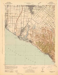
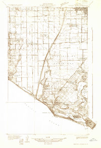 1932 Newport Beach1932 Print · USGSThe Orange County coast was a landscape of agricultural sidings and early seaside resorts in the early thirties. Trace family history through Colonia Juarez, locate the Balboa Ferry, or find old schoolhouses like Greenville Sch.
 - 1932 Map of Tustin
 1932 Tustin1932 Print · USGSOrange County in the early thirties reveals a landscape of massive ranch lands and pioneer aviation. Genealogists and historians can trace the foundations of Tustin and Irvine, identifying local landmarks like the Irvine Ranch Headquarters and the Delhi post office.
 - 1935 Map of Tustin
 1935 Tustin1935 Print · USGSThe citrus groves and ranch lands of Orange County are captured here in the mid-1930s, showing the early footprints of Tustin and Irvine. Trace the local rail-and-ranch economy through features like the Irvine Ranch Headquarters, Delhi (Glorietta PO), and Martins Landing Field.3 unique versions available
 - 1935 Map of Newport Beach
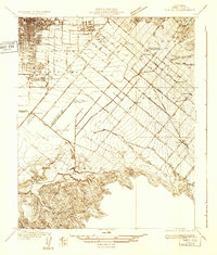
 1935 Newport Beach1935 Print · USGSOrange County's coastline and interior plains are captured in the mid-1930s, showing a transition from citrus groves to coastal resorts. Trace the early development of Lido Isle, the sugar beet settlements of Smeltzer, and the tracks of the Pacific Electric.3 unique versions available
 - 1942 Map of Santa Ana
 1942 Santa Ana1942 Print · USGSOrange County was still a landscape of coastal towns and sprawling citrus groves during the early years of the war. Genealogists and researchers can trace the early footprints of Costa Mesa, the rail-side industry of Sugar, and the distinct shorelines of Newport Bay.2 unique versions available
 - 1947 Map of Santa Ana, 1949 Print
 1947 Santa Ana1949 Print · USGSSouthern California is depicted here in the late forties, showing the expansion of the Inland Empire and the Orange County coast. Researchers can trace the early layout of Palm Springs or locate long-standing tribal lands like the Pala Indian Reservation and Rincon Indian Res.
 - 1948 Map of Tustin, 1957 Print
 1948 Tustin1957 Print · USGSOrange County's agricultural heart was beginning to transform after the war as Tustin and the Irvine Ranch expanded toward the coast. Researchers can trace historic landmarks like Orange County Airport, the Naval Reservation, and old school sites like Delhi Sch.2 unique versions available
 - 1948 Map of Laguna Beach, 1957 Print
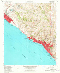
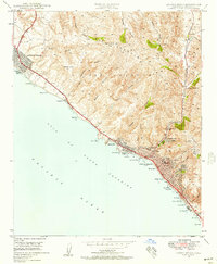 1948 Laguna Beach1957 Print · USGSPost-war Orange County comes to life as Laguna Beach and Corona del Mar begin their modern growth along the Pacific. Researchers can trace the development of coastal coves and interior landmarks like Top of the World, Crystal Cove, and Canyon Acres.2 unique versions available
 - 1949 Map of Laguna Beach
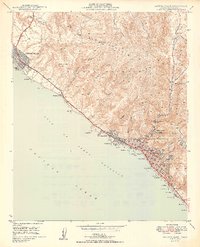 1949 Laguna Beach1949 Print · USGSThe Orange County coast appears in its postwar infancy, where the cliffs and canyons of the SAN JOAQUIN HILLS meet the Pacific. Researchers can trace early residential growth at Corona del Mar and locate local landmarks like the Art Gallery and Rancho Laguna Sch.2 unique versions available
 - 1949 Map of Santa Ana
 1949 Santa Ana1949 Print · USGSSouthern California underwent a profound transformation in the late 1940s as military installations and citrus groves shared the landscape. Researchers can trace early coastal growth at Laguna Beach, military history at Camp Pendleton, and the rail corridors of the Pacific Electric.
 - 1949 Map of Newport Beach, 1958 Print
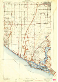
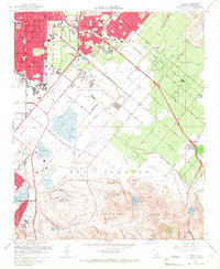
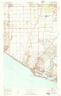 1949 Newport Beach1958 Print · USGSThe Orange County coastline comes alive in this post-war survey, documenting the transition from oil fields to burgeoning seaside communities. Genealogists and historians can trace the foundations of Costa Mesa and Newport Beach while locating landmarks like Orange Coast College and the Pacific Electric railroad.
 - 1950 Map of Tustin
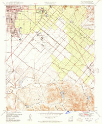
 1950 Tustin1950 Print · USGSMid-century Orange County is captured here during its transition from a powerhouse citrus region to a suburban and military hub. Genealogists and local researchers can locate early landmarks like Irvine Ranch, Tustin High Sch, and the Orange County Airport.2 unique versions available
 - 1951 Map of Newport Beach
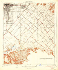
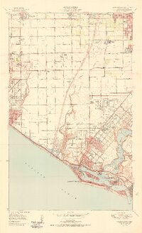 1951 Newport Beach1951 Print · USGSCoastal Orange County in the early fifties reveals a landscape of emerging suburbs and working oil fields before the era of major freeways. Genealogists and local historians can trace the foundations of Costa Mesa and Huntington Beach, or locate vanished landmarks like Balboa Airport and Colonia Juarez.2 unique versions available
 - 1956 Map of Santa Ana
 1956 Santa Ana1956 Print · USGSSouthern California underwent massive mid-century transformation as suburban growth met major military and water projects. Trace the postwar expansion of Santa Ana and Riverside, the layout of Camp Pendleton, and the path of the Colorado River Aqueduct.
 - 1959 Map of Santa Ana, 1971 Print
 1959 Santa Ana1971 Print · USGSSouthern California is captured in a decade of transformation, from the Orange County coast to the desert floor. Researchers can trace the mid-century footprints of Camp Pendleton, March Air Force Base, and the original Ortega Highway.3 unique versions available
 - 1960 Map of Santa Ana
 1960 Santa Ana1960 Print · USGSSouthern California's coastal plains and inland deserts meet in this mid-century survey of the burgeoning Orange and Riverside county corridors. Researchers can trace the layout of early freeway systems, find tribal lands like the Soboba Indian Reservation, and locate military landmarks such as March Field.2 unique versions available
 - 1962 Map of Tustin, 1975 Print
 1962 Tustin1975 Print · USGSOrange County's agricultural heartland undergoes rapid transformation into a modern suburban and institutional hub during the early sixties. Researchers can trace the early footprints of the University of California (Irvine), the Marine Corps Air Facility, and legacy ranch sites like East Irvine.
 - 1965 Map of Santa Ana
 1965 Santa Ana1965 Print · USGSSouthern California is captured in a decade of rapid growth, showing the coastal expansion from Santa Ana down to Oceanside. Genealogists and historians can trace the mid-century development of places like Garden Grove or the rural reaches of Escondido and the Palomar Observatory.
 - 1965 Map of Laguna Beach, 1967 Print
 1965 Laguna Beach1967 Print · USGSCoastal Orange County is captured here during the mid-sixties growth surge, showing the transition from open hills to modern shorefront communities. Researchers can trace local development through landmarks like Crystal Cove, Top of the World, and St Catherine of Siena Sch.4 unique versions available
 - 1965 Map of Tustin, 1967 Print
 1965 Tustin1967 Print · USGSMid-century Orange County is caught in a moment of suburban transformation as the ranch lands transition to university and military use. Genealogists can trace family-named schools and vanished sidings like Irvine (Valencia Siding) and the Twenty Ranch Gun Club.2 unique versions available
Showing maps 1-25 of 46
Top cities near Newport Beach
- Long Beach historical maps
- Anaheim historical maps
- Santa Ana historical maps
- Irvine historical maps
- Huntington Beach historical maps
- Garden Grove historical maps
See more
Top neighborhoods of Newport Beach
- Newport Heights historical maps
- Harbor Island historical maps
- Balboa Island historical maps
- Corona del Mar historical maps
- Corona Highlands historical maps
- Balboa Peninsula historical maps
See more
Frequently asked questions
- What are the different types of historical maps available for Newport Beach?
- What is the oldest map of Newport Beach?
- Where can I purchase historical maps of Newport Beach for my home or office?
- Where can I download high-res historical maps of Newport Beach?
- Are there historical topographic maps available for Newport Beach?
- Is there historical aerial imagery available for Newport Beach?
- Where are historical maps of Newport Beach sourced from?