Old Maps of Orange County, California
Explore 246 old maps of Orange County, spanning from 1896 to today. These high-resolution historic maps reveal how streets, neighborhoods, landmarks, and natural features evolved over time — perfect for genealogy, metal detecting, research, and local history exploration.
What you can do with these maps:
- See how Orange County changed over time: Compare historical maps to modern-day views to trace roads, homesites, rail lines & more.
- View detailed metadata: Each map includes creators, publishers, year, scale, and archive source.
- Overlay maps with satellite & LiDAR: Visualize the past alongside modern tools to explore terrain & human change.
- Trusted historical sources: Maps sourced from the USGS, Library of Congress, and other archives.
- Access maps your way: View online, download high-res files, or order prints for personal or research use.
Start exploring old maps of Orange County to uncover forgotten places, hidden landmarks, and the deep history beneath your feet.
Orange County, CA maps
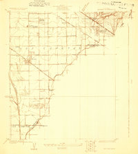
(246)- 1896 Map of Santa Ana
 1896 Santa Ana1896 Print · USGSOrange County was still a land of vast ranchos and emerging citrus towns in the 1890s, well before the post-war suburban boom. You can trace early rail lines like the SANTA ANA AND NEWPORT R. R. and locate vanished coastal landmarks near Arch Beach and Newport Bay.2 unique versions available
 - 1896 Map of Anaheim
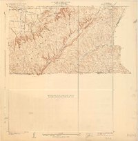
 1896 Anaheim1896 Print · USGSThe Orange County basin appears here in the mid-1890s, when iron rails first connected the young citrus towns to the wider world. Genealogists and researchers can trace the early grids of Anaheim, Fullerton, and Orange alongside now-obscure rail stops like Almond and Marlboro.
 - 1896 Map of Las Bolsas
 1896 Las Bolsas1896 Print · USGSCoastal Orange County appears as a vast network of wetlands and tidal inlets in the mid-1890s, long before the rise of modern beach cities. Trace the early settlement of Anaheim Landing and the original hydrology of Bolsas Creek and La Bolsa Chica.6 unique versions available
 - 1896 Map of Downey
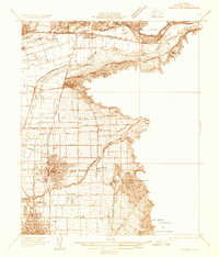
 1896 Downey1896 Print · USGSThe Los Angeles Basin was a landscape of vast ranchos and emerging rail towns in the 1890s. Genealogists and historians can trace the early footprints of Downey and Whittier, alongside unique landmarks like the Poor Farm Sta. and Fulton Wells.
 - 1898 Map of Anaheim, 1899 Print
 1898 Anaheim1899 Print · USGSNorthern Orange County is captured here at the height of its citrus and rail era. Genealogists and local historians can trace the early footprints of Anaheim, Fullerton, and Orange, alongside smaller vanished stops like McPherson and Almond.
 - 1899 Map of Downey
 1899 Downey1899 Print · USGSCoastal Los Angeles County at the close of the nineteenth century reveals a landscape of massive ranchos being carved into early townships. Genealogists can trace family roots through historic rail stops like Obed Bell Sta. and vanished settlements like Spanishtown or Nadeau Park.
 - 1901 Map of Southern California Sheet No. 1
 1901 Southern California Sheet No. 11901 Print · USGSGreater Los Angeles at the dawn of the twentieth century is a landscape of growing citrus towns and a burgeoning rail network. Genealogists and historians can trace the early gridded streets of Hollywood and Pasadena or locate landmarks like Bear Lake and the Cahuilla Indian Reservation.6 unique versions available
 - 1901 Map of Santa Ana
 1901 Santa Ana1901 Print · USGSThe Orange County coast and plains appear here at the dawn of the twentieth century, during a period of agricultural and rail expansion. Genealogists can trace early homesteads near Fairview or locate early rail stops at Smeltzer and Wintersburg.6 unique versions available
 - 1901 Map of Anaheim
 1901 Anaheim1901 Print · USGSOrange County's citrus and rail heartland is meticulously detailed at the start of the century, showing the early layouts of Anaheim and Fullerton. Genealogists can trace early homesteads and rail stops like Loara, Miraflores, and Olinda.6 unique versions available
 - 1901 Map of Elsinore
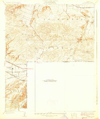
 1901 Elsinore1901 Print · USGSRiverside and the Alessandro Valley are shown here during a peak of early mining and rail expansion. Genealogists and historians can trace the Southern California RR through Perris or locate the Alberhill Coal Mine and Indian School.8 unique versions available
 - 1902 Map of Capistrano
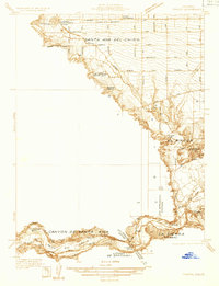
 1902 Capistrano1902 Print · USGSThe Orange County coast and its expansive ranchos are captured here just before the twentieth century's rapid changes. Researchers can trace the early Southern California rail line past Capistrano and explore old canyon routes like Cristianitos.4 unique versions available
 - 1902 Map of Downey
 1902 Downey1902 Print · USGSThe Los Angeles coastal plain at the turn of the century shows a network of early citrus towns and Spanish rancho boundaries. Trace the development of the river system and rail stops like Poor Farm Sta., Fulton Wells, and the growing community of Whittier.9 unique versions available
 - 1902 Map of Corona
 1902 Corona1902 Print · USGSThe Orange County and Riverside borderlands at the start of the 1900s show an era of rapid rail expansion and water engineering. Researchers can trace the early footprints of Anaheim and Orange or find vanished industry at the Santiago Coal Mine.7 unique versions available
 - 1904 Map of Southern California Sheet No. 2
 1904 Southern California Sheet No. 21904 Print · USGSSouthern California during the early 1900s shows the transition from vast ranchos to coastal rail towns. Genealogists and researchers can trace the Southern California R.R. through Oceanside, explore old land grants like Mission Viejo, and locate early settlements from Fallbrook to Julian.5 unique versions available
 - 1904 Map of Southern California Sheet No. 1, 1905 Print
 1904 Southern California Sheet No. 11905 Print · USGSSouthern California at the dawn of the twentieth century shows a landscape of citrus groves and coastal towns connected by rail. Genealogists and historians can trace early settlements like San Juan Capistrano, find remote sites like the Rose Mine, and study the original water systems of the Santa Ana River.2 unique versions available
 - 1906 Map of Capistrano, 1921 Print
 1906 Capistrano1921 Print · USGSThe Orange and San Diego county borderlands appear here just before the turn of the century, when large land grants still defined the coast. You can trace the Southern California railroad line through San Juan down to the remote shores of San Onofre.
 - 1923 Map of Artesia
 1923 Artesia1923 Print · USGSSoutheast Los Angeles and Orange County appear here in the early twenties, showing a rural landscape transitioning into an industrial and oil-producing corridor. Researchers can trace the early footprints of Artesia and Los Alamitos, alongside vanished landmarks like the C Julian Tank Farm and the Bloomfield School.
 - 1925 Map of Long Beach
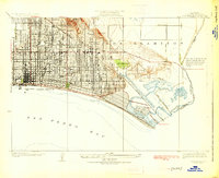 1925 Long Beach1925 Print · USGSIn the mid-1920s, the Southern California coast was rapidly urbanizing around the oil-rich heights and growing beach communities. Researchers can trace the early layout of Naples, the legacy of the Bixby Ranch, and the vital routes of the Pacific Electric railway.2 unique versions available
 - 1925 Map of Artesia
 1925 Artesia1925 Print · USGSThe dairy and oil lands of Los Angeles and Orange Counties are captured here in the mid-twenties as the rail lines were expanding. Researchers can trace the path of the Pacific Electric or locate local landmarks like Artesia Cemetery and the C G Julian Tank Farm.2 unique versions available
 - 1927 Map of La Habra
 1927 La Habra1927 Print · USGSSouthern California ranching meets the oil boom in the late twenties as the petroleum industry reshapes the landscape. Genealogists can locate family holdings like Grazide Ranch or trace local education at Lowell Joint School and Rowland School.2 unique versions available
 - 1928 Map of La Brea
 1928 La Brea1928 Print · USGSThe hills of Eastern Los Angeles County are captured here in the late twenties during a period of expanding ranching and early oil exploration. Genealogists and historians can trace family-named sites like Silver Peak Ranch, local landmarks such as Fairview School, and the path of the Union Pacific Railroad.3 unique versions available
 - 1932 Map of Orange
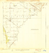
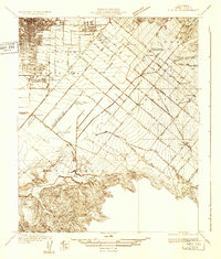
 1932 Orange1932 Print · USGSOrange County was a landscape of expanding citrus groves and irrigation works in the early thirties. Local researchers can trace the development of established city grids and outlying communities like Atwood, McPherson, and El Modena alongside the Santa Ana River.
 - 1932 Map of Newport Beach
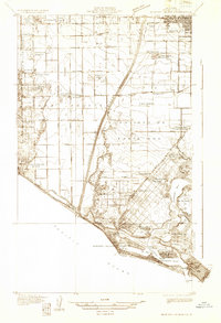 1932 Newport Beach1932 Print · USGSThe Orange County coast was a landscape of agricultural sidings and early seaside resorts in the early thirties. Trace family history through Colonia Juarez, locate the Balboa Ferry, or find old schoolhouses like Greenville Sch.
 - 1932 Map of Tustin
 1932 Tustin1932 Print · USGSOrange County in the early thirties reveals a landscape of massive ranch lands and pioneer aviation. Genealogists and historians can trace the foundations of Tustin and Irvine, identifying local landmarks like the Irvine Ranch Headquarters and the Delhi post office.
 - 1933 Map of Prado
 1933 Prado1933 Print · USGSIn the early 1930s, the Chino Valley was a hub of irrigation canals and rail-side settlements before later development changed the landscape. Genealogists and historians can trace old homesteads like Pellissier Ranch and schools like the California Junior Republic School.
Showing maps 1-25 of 246
Top cities of Orange County
- Anaheim historical maps
- Santa Ana historical maps
- Irvine historical maps
- Huntington Beach historical maps
- Garden Grove historical maps
- Fullerton historical maps
See more
Frequently asked questions
- What are the different types of historical maps available for Orange County?
- What is the oldest map of Orange County?
- Where can I purchase historical maps of Orange County for my home or office?
- Where can I download high-res historical maps of Orange County?
- Are there historical topographic maps available for Orange County?
- Is there historical aerial imagery available for Orange County?
- Where are historical maps of Orange County sourced from?