
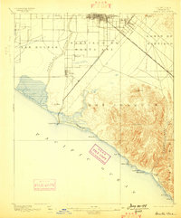
1896 Map of Santa Ana
USGS Topo · Published 1896About this map
Santa Ana and its surrounding ranchos appear here in the mid-1890s, revealing a landscape defined by massive Spanish land grants and the early arrival of the rail. The Atchison Topeka and Santa Fe R. R. cuts diagonally across the coastal plain, connecting Tustin and Irvine to the broader California network. To the south, the Santa Ana and Newport R. R. links the inland citrus and farming hubs directly to Newport Beach and the waters of Newport Bay.
Find a feature on this map
32 named features on this map. Tap any name to fly to it.
Don’t see what you’re looking for? This feature index may not catch every label — zoom into the map to look around manually.
Map Details
Editions of this 1896 Santa Ana Map
2 editions found
Other maps of this area

1896 · Anaheim
USGS Topo · 1:62,500

1896 · Las Bolsas
USGS Topo · 1:62,500

1896 · Downey
USGS Topo · 1:62,500

1898 · Anaheim
USGS Topo · 1:62,500

1899 · Downey
USGS Topo · 1:62,500

1901 · Southern California Sheet No. 1
USGS Topo · 1:250,000

1901 · Santa Ana
USGS Topo · 1:62,500

1901 · Anaheim
USGS Topo · 1:62,500

1902 · Capistrano
USGS Topo · 1:125,000

1902 · Downey
USGS Topo · 1:62,500