1896 Map of Santa Ana
USGS Topo · Published 1899About this map
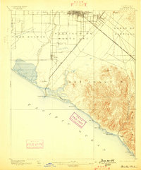
Santa Ana and the surrounding coastal plains are shown here in the late 19th century, during a period of rapid agricultural and transit development in Orange County. The landscape is defined by the course of the Santa Ana River and the sweeping boundaries of old land grants like Las Bolsas and Santiago de Santa Ana. Transport infrastructure is prominent, featuring the Atchison Topeka and Santa Fe R. R. cutting across the plains toward Irvine, while the Santa Ana and Newport R. R. provides a direct link between the inland hub and the coast at Newport Beach. Along the southern shoreline, the terrain transitions into the high ridges of San Joaquin and Niguel, where isolated coastal settlements like Laguna and Arch Beach sit below the steep walls of Laguna Canyon.
Find a feature on this map
31 named features on this map. Tap any name to fly to it.
Don’t see what you’re looking for? This feature index may not catch every label — zoom into the map to look around manually.
Map Details
Editions of this 1896 Santa Ana Map
2 editions found
Other maps of this area

1896 · Santa Ana
USGS Topo · 1:62,500

1896 · Anaheim
USGS Topo · 1:62,500

1896 · Las Bolsas
USGS Topo · 1:62,500

1896 · Downey
USGS Topo · 1:62,500

1898 · Anaheim
USGS Topo · 1:62,500

1899 · Downey
USGS Topo · 1:62,500

1901 · Southern California Sheet No. 1
USGS Topo · 1:250,000

1901 · Santa Ana
USGS Topo · 1:62,500

1901 · Anaheim
USGS Topo · 1:62,500

1902 · Capistrano
USGS Topo · 1:125,000