1940s Maps of Orange County, California
Explore 40 historic maps of Orange County from the 1940s. These maps offer a rare glimpse into what life looked like during the 1940s — showing old roads, neighborhoods, homes, and landmarks that have changed or disappeared over time.
Whether you're researching your family's past, planning a metal detecting trip, or studying how Orange County's landscape evolved across the 1940s, these high-resolution maps are a powerful tool for exploring the history of this region.
- Focus on a specific era: All maps on this page are from the 1940s, giving you a focused view of this time period.
- See what’s changed: Compare century-old streets, trails, and buildings to today's modern landscape using overlays and satellite layers.
- Research with precision: Use these maps for genealogy, historical research, land use analysis, or educational projects.
- View, download, or print: Maps are fully viewable online in high resolution, and can be downloaded or printed for your own records.
Start exploring Orange County's history through authentic maps from the 1940s. This is your window into the past.
Orange County, CA maps
(40)- 1941 Map of Prado
 1941 Prado1941 Print · USGSSouthern California's inland corridor is captured here in the 1930s, showing the river valley before the dam changed the landscape forever. Trace the old routes of the Union Pacific through Prado and locate local landmarks like the Pellissier Ranch.2 unique versions available
 - 1941 Map of Las Bolsas, 1961 Print
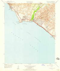
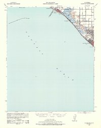 1941 Las Bolsas1961 Print · USGSCoastal Orange County appears at the brink of the war years, showing a shoreline defined by marshlands and early beach communities. Genealogists and local historians can trace the Pacific Electric line and explore landmarks like the Bolsa Chica Gun Club and Meadow Lark Country Club Sch.2 unique versions available
 - 1942 Map of Downey
 1942 Downey1942 Print · USGSThe Los Angeles Basin and North Orange County appear here during the wartime boom, showcasing a landscape transitioning from ranchos to suburbs. Trace the historic Pacific Electric rail lines, the oil fields of Santa Fe Springs, and early settlements like Hynes and Studebaker.
 - 1942 Map of Lake Elsinore
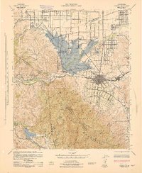
 1942 Lake Elsinore1942 Print · USGSIn the early war years, this area of Riverside County remained a mix of mining outposts, large ranchos, and lakefront towns. Genealogists and historians can trace family properties like Lyne Ranch and Baker Ranch or follow the old Santa Fe Railroad past Terra Cotta and Willard.
 - 1942 Map of Anaheim
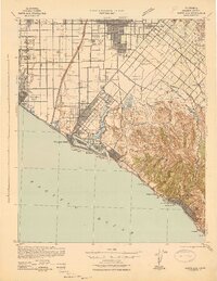
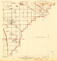
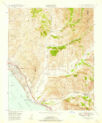
 1942 Anaheim1942 Print · USGSOrange County's agricultural heart is captured mid-century during a period of rapid wartime development. Genealogists can locate family landmarks like Diamond Bar Ranch, local schools such as Alamitos Sch, and communities like Garden Grove or Stanton.2 unique versions available
 - 1942 Map of San Juan Capistrano
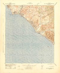 1942 San Juan Capistrano1942 Print · USGSCoastal Orange and San Diego counties are captured here in the early 1940s as the classic California beach towns began to take shape. Genealogists and local historians can trace early settlements and transit hubs from San Juan Capistrano to the Villa Auto Camp and the CCC Camp near San Clemente.
 - 1942 Map of Santa Ana
 1942 Santa Ana1942 Print · USGSOrange County was still a landscape of coastal towns and sprawling citrus groves during the early years of the war. Genealogists and researchers can trace the early footprints of Costa Mesa, the rail-side industry of Sugar, and the distinct shorelines of Newport Bay.2 unique versions available
 - 1942 Map of Santiago Peak, 1943 Print
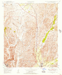
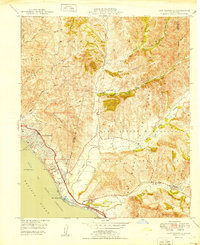
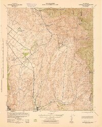 1942 Santiago Peak1943 Print · USGSOrange County and the inland canyons appear here in the early 1940s, showing a landscape of small settlements and rugged mountain reaches. Genealogists and local historians can trace early holdings near San Juan Capistrano, the station at El Toro, and mountain landmarks like Modjeska.3 unique versions available
 - 1942 Map of Corona, 1947 Print
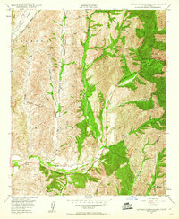
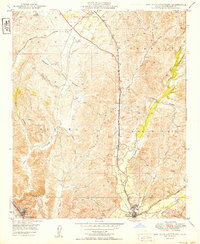
 1942 Corona1947 Print · USGSRiverside County at the dawn of the 1940s reveals a unique mix of agricultural roots, mountain canyons, and significant regional infrastructure projects. Genealogists and local historians can trace the early street plans of Corona and Norco, or locate landmarks like the East Vale Sch and the Santiago Reservoir.2 unique versions available
 - 1943 Map of Corona
 1943 Corona1943 Print · USGSThe Santa Ana River valley during the mid-forties shows a landscape shaped by water management and early inland growth. Trace the development of Corona and Norco alongside the massive Prado Dam and local landmarks like the East Vale Sch.
 - 1943 Map of Las Bolsas
 1943 Las Bolsas1943 Print · USGSThe Orange County coast and wetlands come into focus during the early 1940s as agricultural grids meet the sea. Local historians can trace the early rail influence of the Pacific Electric and locate old landmarks like the Springdale Sch or Wintersburg.
 - 1943 Map of San Pedro
 1943 San Pedro1943 Print · USGSThe South Bay and Los Angeles Harbor area appear here during the Second World War, showing a landscape of burgeoning industry and aviation. Trace wartime infrastructure and local landmarks like Hughes Airport, Terminal Island, and Inglewood Park Cem.
 - 1943 Map of Downey, 1963 Print
 1943 Downey1963 Print · USGSSoutheast Los Angeles County and northern Orange County appear here at the height of the mid-century boom. Researchers can trace the massive rail infrastructure of the Pacific Electric and locate landmarks like the County Hospital and Signal Hill.2 unique versions available
 - 1945 Map of Artesia
 1945 Artesia1945 Print · USGSSoutheast Los Angeles County is captured here during the final stages of its agricultural era. Genealogists and researchers can trace family lands near Artesia, locate the Excelsior Union High School, and follow the Pacific Electric rail lines.
 - 1947 Map of Santa Ana, 1949 Print
 1947 Santa Ana1949 Print · USGSSouthern California is depicted here in the late forties, showing the expansion of the Inland Empire and the Orange County coast. Researchers can trace the early layout of Palm Springs or locate long-standing tribal lands like the Pala Indian Reservation and Rincon Indian Res.
 - 1948 Map of Tustin, 1957 Print
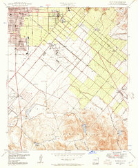 1948 Tustin1957 Print · USGSOrange County's agricultural heart was beginning to transform after the war as Tustin and the Irvine Ranch expanded toward the coast. Researchers can trace historic landmarks like Orange County Airport, the Naval Reservation, and old school sites like Delhi Sch.2 unique versions available
 - 1948 Map of Laguna Beach, 1957 Print
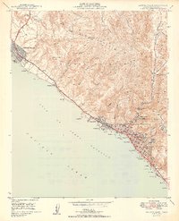
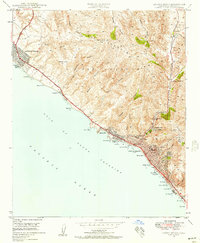 1948 Laguna Beach1957 Print · USGSPost-war Orange County comes to life as Laguna Beach and Corona del Mar begin their modern growth along the Pacific. Researchers can trace the development of coastal coves and interior landmarks like Top of the World, Crystal Cove, and Canyon Acres.2 unique versions available
 - 1948 Map of San Juan Capistrano, 1957 Print
 1948 San Juan Capistrano1957 Print · USGSSouthern Orange County appears in the late 1940s as a land of expansive ranching grants and quiet valley settlements. You can trace the historic Mission at San Juan Capistrano, the winding Atchison Topeka and Santa Fe rail line, and early coastal life near South Laguna.3 unique versions available
 - 1948 Map of San Clemente, 1958 Print
 1948 San Clemente1958 Print · USGSThe Orange and San Diego county line met a rapidly changing landscape in the late 1940s as coastal development sat beside military expansion. Researchers can trace the early streets of San Clemente, the path of the Coast Highway, and the expansive Camp Joseph H Pendleton Naval Reservation.2 unique versions available
 - 1948 Map of Dana Point, 1959 Print
 1948 Dana Point1959 Print · USGSThe Orange County coastline was transitioning into a modern residential hub in the late 1940s. Genealogists and historians can trace the early layout of Dana Point, the grounds of Doheny Beach State Park, and the site of the Capistrano Airport.3 unique versions available
 - 1948 Map of Canada Gobernadora, 1960 Print
 1948 Canada Gobernadora1960 Print · USGSOrange County's canyon country remained largely rural in the late 1940s, split between the historic Mission Viejo and Trabuco grants. Researchers can locate the Old Mission Site, trace the original Ortega Highway, and find the San Juan Hot Springs.2 unique versions available
 - 1948 Map of San Onofre Bluff, 1966 Print
 1948 San Onofre Bluff1966 Print · USGSCoastal San Diego County is captured just after the war, showing the military and transit corridor along the Pacific. Researchers can trace the original route of the Santa Fe Highway and the Atchison Topeka and Santa Fe railroad as they skirt San Onofre Bluff near Agra.
 - 1949 Map of San Clemente
 1949 San Clemente1949 Print · USGSThe Orange and San Diego County line met at the Pacific shore in the late 1940s, just as this coastal region began its post-war transformation. Researchers can trace the early city streets of San Clemente, the path of the Atchison Topeka and Santa Fe, and the expansive Mission Viejo territory.
 - 1949 Map of San Juan Capistrano
 1949 San Juan Capistrano1949 Print · USGSCoastal Orange County in the late 1940s retains its pastoral character, centered on the historic Mission at San Juan Capistrano. Genealogists and local historians can trace the early rail-and-road corridor of the Atchison Topeka and Santa Fe and the original Ortega Highway.
 - 1949 Map of Laguna Beach
 1949 Laguna Beach1949 Print · USGSThe Orange County coast appears in its postwar infancy, where the cliffs and canyons of the SAN JOAQUIN HILLS meet the Pacific. Researchers can trace early residential growth at Corona del Mar and locate local landmarks like the Art Gallery and Rancho Laguna Sch.2 unique versions available
Showing maps 1-25 of 40
Top cities of Orange County
- Anaheim historical maps
- Santa Ana historical maps
- Irvine historical maps
- Huntington Beach historical maps
- Garden Grove historical maps
- Fullerton historical maps
See more
Frequently asked questions
- What are the different types of historical maps available for Orange County?
- What is the oldest map of Orange County?
- Where can I purchase historical maps of Orange County for my home or office?
- Where can I download high-res historical maps of Orange County?
- Are there historical topographic maps available for Orange County?
- Is there historical aerial imagery available for Orange County?
- Where are historical maps of Orange County sourced from?