1930s Maps of Orange County, California
Explore 13 historic maps of Orange County from the 1930s. These maps offer a rare glimpse into what life looked like during the 1930s — showing old roads, neighborhoods, homes, and landmarks that have changed or disappeared over time.
Whether you're researching your family's past, planning a metal detecting trip, or studying how Orange County's landscape evolved across the 1930s, these high-resolution maps are a powerful tool for exploring the history of this region.
- Focus on a specific era: All maps on this page are from the 1930s, giving you a focused view of this time period.
- See what’s changed: Compare century-old streets, trails, and buildings to today's modern landscape using overlays and satellite layers.
- Research with precision: Use these maps for genealogy, historical research, land use analysis, or educational projects.
- View, download, or print: Maps are fully viewable online in high resolution, and can be downloaded or printed for your own records.
Start exploring Orange County's history through authentic maps from the 1930s. This is your window into the past.
Orange County, CA maps
(13)- 1932 Map of Orange
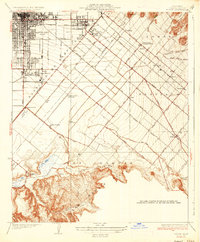
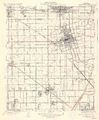
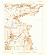 1932 Orange1932 Print · USGSOrange County was a landscape of expanding citrus groves and irrigation works in the early thirties. Local researchers can trace the development of established city grids and outlying communities like Atwood, McPherson, and El Modena alongside the Santa Ana River.
 - 1932 Map of Newport Beach
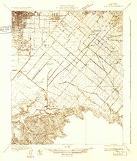
 1932 Newport Beach1932 Print · USGSThe Orange County coast was a landscape of agricultural sidings and early seaside resorts in the early thirties. Trace family history through Colonia Juarez, locate the Balboa Ferry, or find old schoolhouses like Greenville Sch.
 - 1932 Map of Tustin
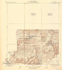
 1932 Tustin1932 Print · USGSOrange County in the early thirties reveals a landscape of massive ranch lands and pioneer aviation. Genealogists and historians can trace the foundations of Tustin and Irvine, identifying local landmarks like the Irvine Ranch Headquarters and the Delhi post office.
 - 1933 Map of Prado
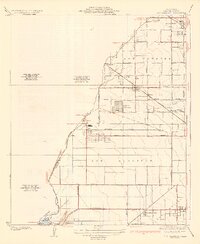
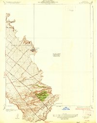
 1933 Prado1933 Print · USGSIn the early 1930s, the Chino Valley was a hub of irrigation canals and rail-side settlements before later development changed the landscape. Genealogists and historians can trace old homesteads like Pellissier Ranch and schools like the California Junior Republic School.
 - 1935 Map of Los Alamitos
 1935 Los Alamitos1935 Print · USGSOrange County's coastal plain is captured in the mid-thirties as rural ranch lands began to yield to industrial expansion. Genealogists and researchers can trace early settlements like Los Alamitos and Buena Park or locate landmarks like the Texas Oil Tank Farm.2 unique versions available
 - 1935 Map of Coyote Hills
 1935 Coyote Hills1935 Print · USGSThe Orange and Los Angeles county line comes alive in the 1930s as citrus ranches and oil infrastructure began to reshape the Coyote Hills. Researchers can trace the early footprints of Brea, the expansive Bastonchury Ranch, and the Union Oil Tank Farm.2 unique versions available
 - 1935 Map of Olinda
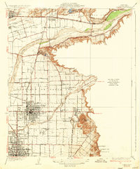
 1935 Olinda1935 Print · USGSOrange County in the mid-1930s shows an evolving landscape of rail lines and irrigation networks. Genealogists and local historians can trace the early footprints of Yorba Linda and Placentia, or locate defunct rail stops like Loftus and Carlton.
 - 1935 Map of Tustin
 1935 Tustin1935 Print · USGSThe citrus groves and ranch lands of Orange County are captured here in the mid-1930s, showing the early footprints of Tustin and Irvine. Trace the local rail-and-ranch economy through features like the Irvine Ranch Headquarters, Delhi (Glorietta PO), and Martins Landing Field.3 unique versions available
 - 1935 Map of Seal Beach
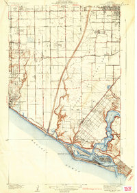
 1935 Seal Beach1935 Print · USGSThe Orange County coast in the mid-thirties remains a landscape of sprawling salt marshes and private gun clubs. Trace the early shorefront at Sunset Beach or locate historic markers like Anaheim Landing and the Springdale Sch.3 unique versions available
 - 1935 Map of Garden Grove
 1935 Garden Grove1935 Print · USGSOrange County's citrus heartland is captured here in the mid-1930s, showing a grid of groves and rail lines. Trace family history at Colonia Manzanillo, find the Anaheim Cem, or locate the old Fullerton Landing Field.3 unique versions available
 - 1935 Map of El Toro
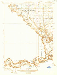
 1935 El Toro1935 Print · USGSOrange County ranching culture thrives in the 1930s, centered on the settlement of El Toro and the surrounding canyon washes. Researchers can trace early infrastructure along the Atchison Topeka and Santa Fe railroad and locate historic homesteads like Moulton Ranch and Serrano Place.4 unique versions available
 - 1935 Map of Newport Beach
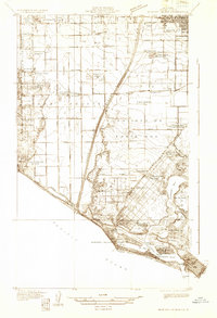
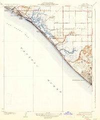
 1935 Newport Beach1935 Print · USGSOrange County's coastline and interior plains are captured in the mid-1930s, showing a transition from citrus groves to coastal resorts. Trace the early development of Lido Isle, the sugar beet settlements of Smeltzer, and the tracks of the Pacific Electric.3 unique versions available
 - 1935 Map of Orange
 1935 Orange1935 Print · USGSOrange County's citrus-rich heartland is captured in the mid-1930s, revealing a landscape of burgeoning towns and vital rail lines. Genealogists can trace early homesteads near St Johns Cem, the Villa Park Sch, and the El Modena Sta.2 unique versions available
End of results
Showing maps 1-13 of 13
Top cities of Orange County
- Anaheim historical maps
- Santa Ana historical maps
- Irvine historical maps
- Huntington Beach historical maps
- Garden Grove historical maps
- Fullerton historical maps
See more
Frequently asked questions
- What are the different types of historical maps available for Orange County?
- What is the oldest map of Orange County?
- Where can I purchase historical maps of Orange County for my home or office?
- Where can I download high-res historical maps of Orange County?
- Are there historical topographic maps available for Orange County?
- Is there historical aerial imagery available for Orange County?
- Where are historical maps of Orange County sourced from?