1970s Maps of Orange County, California
Explore 19 historic maps of Orange County from the 1970s. These maps offer a rare glimpse into what life looked like during the 1970s — showing old roads, neighborhoods, homes, and landmarks that have changed or disappeared over time.
Whether you're researching your family's past, planning a metal detecting trip, or studying how Orange County's landscape evolved across the 1970s, these high-resolution maps are a powerful tool for exploring the history of this region.
- Focus on a specific era: All maps on this page are from the 1970s, giving you a focused view of this time period.
- See what’s changed: Compare century-old streets, trails, and buildings to today's modern landscape using overlays and satellite layers.
- Research with precision: Use these maps for genealogy, historical research, land use analysis, or educational projects.
- View, download, or print: Maps are fully viewable online in high resolution, and can be downloaded or printed for your own records.
Start exploring Orange County's history through authentic maps from the 1970s. This is your window into the past.
Orange County, CA maps
(19)- 1974 Map of El Toro, 1975 Print
 1974 El Toro1975 Print · USGSOrange County's military and agricultural landscape is captured with exceptional clarity in the mid-seventies just as development began pressing into the hills. Researchers can trace the full footprint of the El Toro Marine Corps Air Station and the rising terrain of the eastern Ridge.
 - 1974 Map of Santiago Peak, 1975 Print
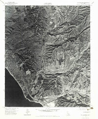
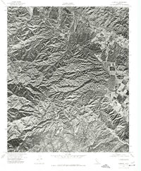
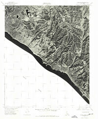
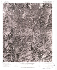
 1974 Santiago Peak1975 Print · USGSOrange County's high summits and deep canyons are captured in detail during the mid-seventies, showing the landscape as it appeared before major suburban growth. Researchers can trace the rugged drainage patterns of Silverado Canyon and the prominent heights of Santiago Peak.
 - 1974 Map of Costa Mesa, 1975 Print
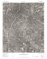
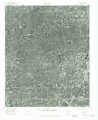
 1974 Costa Mesa1975 Print · USGSOrange County's coastal plain is documented at a moment of intense suburban growth during the mid-seventies. Trace the 1974 development of Costa Mesa and Fountain Valley along the banks of the Santa Ana River.
 - 1974 Map of San Clemente, 1975 Print
 1974 San Clemente1975 Print · USGSCoastal Orange County meets the sprawling training grounds of the Marines in the mid-seventies. Researchers can trace the rugged topography of Gabino Canyon and the coastal interface at Camp Pendleton Marine Corps Base.2 unique versions available
 - 1974 Map of Whittier, 1975 Print
 1974 Whittier1975 Print · USGSThe residential and industrial expansion of Southeast Los Angeles is captured in this mid-seventies photographic survey. Genealogists and researchers can trace the detailed street grids and commercial development of Whittier, Downey, and Pico Rivera.
 - 1974 Map of Corona South, 1975 Print
 1974 Corona South1975 Print · USGSRiverside and Orange County landscapes are captured in 1974 through high-resolution aerial imagery during a period of rapid suburban expansion. Researchers can trace the intersection of commercial agriculture and natural terrain through the winding path of Bedford Canyon.
 - 1974 Map of Tustin, 1975 Print
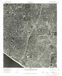
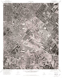 1974 Tustin1975 Print · USGSOrange County enters a period of rapid suburban growth in the mid-seventies, captured here through high-resolution aerial photography. Trace the early expansion of Newport Beach and the fading footprint of local orchards and commercial farmland.
 - 1974 Map of Alberhill, 1977 Print
 1974 Alberhill1977 Print · USGSThe Temescal Valley and surrounding highlands are captured in this mid-seventies orthophoto, showing the region's rugged geography. Trace the industrial footprint of Alberhill or follow the elevation change up to Trabuco Peak.
 - 1974 Map of Anaheim, 1977 Print
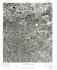
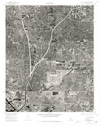
 1974 Anaheim1977 Print · USGSOrange County's rapid suburban transformation is captured in this mid-seventies aerial survey. Trace the residential and commercial growth of Anaheim, Garden Grove, and Buena Park as they flank the Santa Ana River.
 - 1974 Map of La Habra, 1977 Print
 1974 La Habra1977 Print · USGSOrange County underwent rapid transformation in the mid-seventies, as shown in this detailed aerial study. Genealogists and local historians can trace the specific development of residential blocks and commercial corridors in La Habra and Fullerton.
 - 1974 Map of Canada Gobernadora, 1977 Print
 1974 Canada Gobernadora1977 Print · USGSSouthern Orange County appears in detailed 1970s aerial photography, showcasing the rural canyon systems before suburban expansion. Trace the natural paths of Cañada Gobernadora, Gabino Canyon, and Lucas Canyon across the landscape.
 - 1974 Map of Laguna Beach, 1977 Print
 1974 Laguna Beach1977 Print · USGSThe Orange County coast is captured during the mid-seventies, showing the developing shoreline before the heavy expansion of the late twentieth century. Trace the early layout of Laguna Beach and the canyons of the San Joaquin Hills.
 - 1974 Map of Orange, 1977 Print
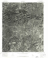
 1974 Orange1977 Print · USGSCoastal California suburbanization is on full display in the mid-1970s as residential tracts push into the foothills. Researchers can examine the literal landscape of this era in high-resolution aerial detail, tracing the layout of Lemon Heights.
 - 1974 Map of Dana Point, 1977 Print
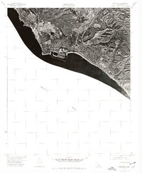 1974 Dana Point1977 Print · USGSCoastal Orange County is captured in the mid-1970s during a decade of rapid suburban transformation. Local historians can trace the early harbor structures at Dana Point and the residential footprint of San Clemente along the Pacific Ocean.
 - 1974 Map of Seal Beach, 1977 Print
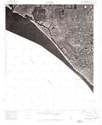 1974 Seal Beach1977 Print · USGSThe Orange County coast comes into sharp focus in the mid-1970s, showing the rapid suburbanization of the shoreline. Trace the expansion of Seal Beach and Huntington Beach through these detailed aerial photographs.
 - 1974 Map of San Juan Capistrano, 1977 Print
 1974 San Juan Capistrano1977 Print · USGSCoastal Orange County undergoes a period of rapid suburban growth in the mid-1970s, as seen from this unique aerial perspective. Researchers can trace the early development of modern residential tracts and infrastructure surrounding the historic San Juan Capistrano.
 - 1974 Map of Los Alamitos, 1977 Print
 1974 Los Alamitos1977 Print · USGSNorthern Orange County comes into sharp focus during the mid-seventies, showing the dense suburban development of Los Alamitos. Trace the growth of the region through its residential grids and industrial landmarks near Garden Grove.
 - 1974 Map of Sitton Peak, 1977 Print
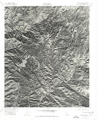 1974 Sitton Peak1977 Print · USGSRiverside and Orange County borderlands are shown through 1970s aerial photography just before major regional growth. Researchers can trace the sharp ridgelines of Sitton Peak and the deep drainage paths of San Mateo Canyon and Morrell Canyon.
 - 1974 Map of Black Star Canyon, 1977 Print
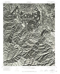
 1974 Black Star Canyon1977 Print · USGSThe Santa Ana Mountains are captured in detail during the mid-seventies, showing this rugged landscape before suburban expansion. Researchers can trace the original shoreline of Santiago Reservoir and the natural path of the Santa Ana River.
End of results
Showing maps 1-19 of 19
Top cities of Orange County
- Anaheim historical maps
- Santa Ana historical maps
- Irvine historical maps
- Huntington Beach historical maps
- Garden Grove historical maps
- Fullerton historical maps
See more
Frequently asked questions
- What are the different types of historical maps available for Orange County?
- What is the oldest map of Orange County?
- Where can I purchase historical maps of Orange County for my home or office?
- Where can I download high-res historical maps of Orange County?
- Are there historical topographic maps available for Orange County?
- Is there historical aerial imagery available for Orange County?
- Where are historical maps of Orange County sourced from?