1900s (20th Century) Maps of Auburn, California
Explore 10 historic maps of Auburn from the 1900s (20th Century). These maps offer a rare glimpse into what life looked like during the 1900s — showing old roads, neighborhoods, homes, and landmarks that have changed or disappeared over time.
Whether you're researching your family's past, planning a metal detecting trip, or studying how Auburn's landscape evolved across the 1900s, these high-resolution maps are a powerful tool for exploring the history of this region.
- Focus on a specific era: All maps on this page are from the 1900s, giving you a focused view of this time period.
- See what’s changed: Compare century-old streets, trails, and buildings to today's modern landscape using overlays and satellite layers.
- Research with precision: Use these maps for genealogy, historical research, land use analysis, or educational projects.
- View, download, or print: Maps are fully viewable online in high resolution, and can be downloaded or printed for your own records.
Start exploring Auburn's history through authentic maps from the 1900s. This is your window into the past.
Auburn, CA maps
(10)- 1944 Map of Auburn
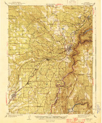 1944 Auburn1944 Print · USGSThe Placer County foothills in the early 1940s show a landscape of deep river canyons and growing rail towns. Researchers can trace rural school districts like Japanese Sch and old river crossings at Rattlesnake Bridge and Salmon Falls.3 unique versions available
 - 1947 Map of Sacramento, 1948 Print
 1947 Sacramento1948 Print · USGSThe Sacramento Valley meets the high Sierra during a period of post-war expansion. Trace the historic river delta islands like Grand Island or locate early airfield footprints at McClellan Air Force Base and Mather Air Force Base.2 unique versions available
 - 1948 Map of Sacramento, 1951 Print
 1948 Sacramento1951 Print · USGSPost-war Northern California comes alive in this regional survey, capturing the era of expansion between the Central Valley and the High Sierra. Researchers can trace the rail networks of the Central California Traction and Sacramento Northern RR or locate landmarks like the State Capitol and University of California Davis.
 - 1953 Map of Auburn, 1955 Print
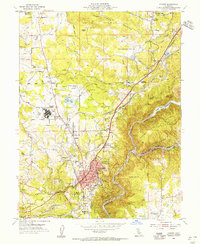 1953 Auburn1955 Print · USGSMid-century Auburn is captured here at the intersection of early highway travel and the historic Southern Pacific rail line. Researchers can trace the intricate canal system feeding Lake Clementine, or locate sites like DeWitt State Hospital and Honor Camp No 7.9 unique versions available
 - 1954 Map of Pilot Hill, 1955 Print
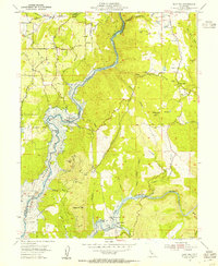 1954 Pilot Hill1955 Print · USGSEl Dorado County in the mid-fifties shows the American River canyons just before the rising Folsom Reservoir submerged the historic riverbars. Researchers can trace the original locations of Salmon Falls, Whiskey Bar, and the Zantgraf Mine.4 unique versions available
 - 1954 Map of Auburn, 1959 Print
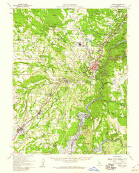 1954 Auburn1959 Print · USGSThe Gold Country foothills of Placer and El Dorado Counties are captured here during the mid-fifties, just as the valley floor prepared for the rise of the Folsom Reservoir. Researchers can trace the river's historic mining bars or locate legacy landmarks like the Auburn Rancheria, Bayley House, and Clipper Gap.2 unique versions available
 - 1956 Map of Sacramento
 1956 Sacramento1956 Print · USGSMid-century California unfolds from the delta to the high Sierra, capturing a landscape of growing valley cities and burgeoning military airbases. Genealogists and historians can trace the rail lines and river towns from Woodland to Lodi, or explore the foothill settlements of Placerville and Jackson.2 unique versions available
 - 1957 Map of Sacramento, 1966 Print
 1957 Sacramento1966 Print · USGSIn the mid-twentieth century, the California heartland was a hub of river transport, rail lines, and military airbases. Genealogists and historians can trace the development of Gold Country towns like Angels Camp and Sonora or follow the path of the Southern Pacific RR through the growing suburbs of Sacramento.4 unique versions available
 - 1975 Map of Auburn, 1981 Print
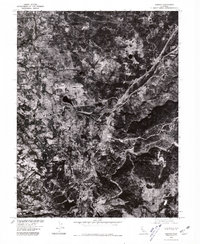 1975 Auburn1981 Print · USGSThe Placer County foothills in the mid-seventies are documented here through high-resolution aerial photography. Genealogists and historians can trace the footprint of Auburn, the Dewitt State Hospital grounds, and outlying locales like Clipper Gap.
 - 1994 Map of Sacramento
 1994 Sacramento1994 Print · USGSThe Sacramento valley was a landscape of massive flood control and military aviation during the mid-nineties. Researchers can trace the complex network of the Yolo Bypass and the Sacramento River alongside McClellan Air Force Base and Zamora.2 unique versions available
End of results
Showing maps 1-10 of 10
Top cities near Auburn
- Roseville historical maps
- Citrus Heights historical maps
- Folsom historical maps
- Rocklin historical maps
- El Dorado Hills historical maps
- Lincoln historical maps
See more
Frequently asked questions
- What are the different types of historical maps available for Auburn?
- What is the oldest map of Auburn?
- Where can I purchase historical maps of Auburn for my home or office?
- Where can I download high-res historical maps of Auburn?
- Are there historical topographic maps available for Auburn?
- Is there historical aerial imagery available for Auburn?
- Where are historical maps of Auburn sourced from?