1900s (20th Century) Maps of Hughes Mill, California
Explore 10 historic maps of Hughes Mill from the 1900s (20th Century). These maps offer a rare glimpse into what life looked like during the 1900s — showing old roads, neighborhoods, homes, and landmarks that have changed or disappeared over time.
Whether you're researching your family's past, planning a metal detecting trip, or studying how Hughes Mill's landscape evolved across the 1900s, these high-resolution maps are a powerful tool for exploring the history of this region.
- Focus on a specific era: All maps on this page are from the 1900s, giving you a focused view of this time period.
- See what’s changed: Compare century-old streets, trails, and buildings to today's modern landscape using overlays and satellite layers.
- Research with precision: Use these maps for genealogy, historical research, land use analysis, or educational projects.
- View, download, or print: Maps are fully viewable online in high resolution, and can be downloaded or printed for your own records.
Start exploring Hughes Mill's history through authentic maps from the 1900s. This is your window into the past.
Hughes Mill, CA maps
(10)- 1900 Map of Colfax
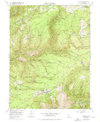
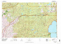
 1900 Colfax1900 Print · USGSThe Sierra Nevada foothills and high peaks are shown at the turn of the century as the mining economy and transcontinental rail travel reached their maturity. Researchers can trace historic industrial sites like the Alaska Mine, remote camps such as Moores Flat, and the path of the Southern Pacific RR.
 - 1902 Map of Colfax
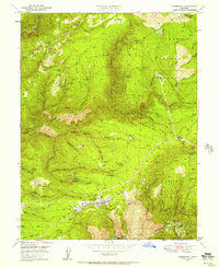
 1902 Colfax1902 Print · USGSGold-rush towns and hydraulic mining sites define this portion of the Sierra Nevada at the turn of the century. Genealogists and historians can trace the foundations of North Bloomfield, locate the remote Alaska Mine, or follow the Southern Pacific through Emigrant Gap.7 unique versions available
 - 1938 Map of Colfax
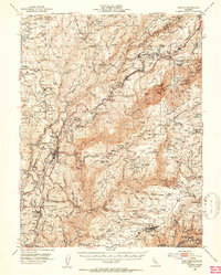
 1938 Colfax1938 Print · USGSThe Sierra Nevada's gold and timber country comes into focus in the late 1930s, showing a landscape defined by deep river canyons and industrial high-country camps. Researchers can locate remote sites like the Sixteen to One Mine, the North Bloomfield Ranger Station, and vanished settlements like Lake City.3 unique versions available
 - 1948 Map of Foresthill, 1975 Print
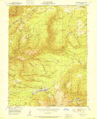
 1948 Foresthill1975 Print · USGSThe gold-bearing ridges of the Sierra Nevada foothills come alive in this mid-century survey of the Placer County mining country. Genealogists and historians can locate family claims and old outposts like Yankee Jims, the Mayflower Mine, and Ebberts Ranch.
 - 1949 Map of Foresthill, 1957 Print
 1949 Foresthill1957 Print · USGSPlacer County gold mining country is captured here during the late 1940s, showing the ridge-top settlements and deep river canyons. Genealogists and historians can trace family-named sites like Ebberts Ranch, the Mayflower Mine, and the old Iowa Hill diggings.4 unique versions available
 - 1950 Map of Colfax, 1953 Print
 1950 Colfax1953 Print · USGSPlacer and Nevada Counties are shown here during the early post-war years, as the Mother Lode's industrial footprint remained clearly visible. Genealogists and historians can trace the Southern Pacific line through historic sites like Illinoistown and active communities such as Foresthill and Weimar.4 unique versions available
 - 1951 Map of Foresthill
 1951 Foresthill1951 Print · USGSIn the Gold Country of the 1950s, the Sierra Nevada ridges were defined by decades of mining and the timber industry. Researchers can trace the extensive Placer Diggings and historic claims like the Baltimore Mine, Mayflower Mine, and Morning Star Mine.
 - 1958 Map of Chico, 1962 Print
 1958 Chico1962 Print · USGSMid-century Northern California comes to life across the Central Valley and high Sierras as the postwar economy transformed the landscape. Trace the rail lines of the Southern Pacific RR, locate family roots near Chico Cem, or explore the early layout of Paradise and Beale Air Force Base.4 unique versions available
 - 1960 Map of Chico
 1960 Chico1960 Print · USGSThe Northern California high country and Sacramento Valley meet in this 1960s-era landscape of mining towns and river settlements. Trace the rail-and-water economy of the gold country through the Empire Mine, Beale Air Force Base, and the Western Pacific Railroad.
 - 1977 Map of Truckee, 1978 Print
 1977 Truckee1978 Print · USGSThe High Sierra and Lake Tahoe regions come into focus in the late seventies, showing a landscape defined by massive reservoir projects and mountain transit. Genealogists and historians can trace the Southern Pacific rail line through Truckee or explore old mining districts near North Bloomfield and Colfax.2 unique versions available
End of results
Showing maps 1-10 of 10
Top cities near Hughes Mill
Frequently asked questions
- What are the different types of historical maps available for Hughes Mill?
- What is the oldest map of Hughes Mill?
- Where can I purchase historical maps of Hughes Mill for my home or office?
- Where can I download high-res historical maps of Hughes Mill?
- Are there historical topographic maps available for Hughes Mill?
- Is there historical aerial imagery available for Hughes Mill?
- Where are historical maps of Hughes Mill sourced from?