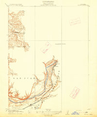
1900s (20th Century) Maps of Roseville, California
Explore 31 historic maps of Roseville from the 1900s (20th Century). These maps offer a rare glimpse into what life looked like during the 1900s — showing old roads, neighborhoods, homes, and landmarks that have changed or disappeared over time.
Whether you're researching your family's past, planning a metal detecting trip, or studying how Roseville's landscape evolved across the 1900s, these high-resolution maps are a powerful tool for exploring the history of this region.
- Focus on a specific era: All maps on this page are from the 1900s, giving you a focused view of this time period.
- See what’s changed: Compare century-old streets, trails, and buildings to today's modern landscape using overlays and satellite layers.
- Research with precision: Use these maps for genealogy, historical research, land use analysis, or educational projects.
- View, download, or print: Maps are fully viewable online in high resolution, and can be downloaded or printed for your own records.
Start exploring Roseville's history through authentic maps from the 1900s. This is your window into the past.
Roseville, CA maps
(31)- 1902 Map of Fairoaks
 1902 Fairoaks1902 Print · USGSSacramento and its surrounding ranchlands were undergoing a rapid rail-driven transformation at the start of the century. You can trace the early street grids of Oak Park and Highland Park or locate vanished stops like Twelvemile House and Walsh Station.2 unique versions available
 - 1910 Map of Roseville
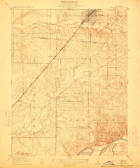
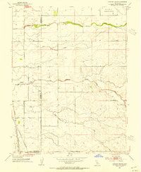
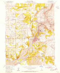
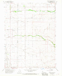
 1910 Roseville1910 Print · USGSRoseville was a burgeoning railroad town when this 1908 survey recorded its early street grid and rail junctions. Trace the tracks of the Southern Pacific through Whitney or locate rural landmarks like the Pleasant Grove School and Kaseberg farm.2 unique versions available
 - 1910 Map of Pleasant Grove
 1910 Pleasant Grove1910 Print · USGSThe Sacramento Valley landscape near the Sutter and Placer county line appears here in the early twentieth century, dominated by agricultural plains and interurban rail. Researchers can trace the early path of the Northern Electric RR and find rural landmarks like Eagle School and Alpha School.2 unique versions available
 - 1911 Map of Antelope
 1911 Antelope1911 Print · USGSThe Placer and Sacramento county borderlands are captured here just after the turn of the century, centered on the growing rail hub at Roseville. Genealogists and local historians can trace early school districts at Sylvan and San Juan, and locate the historic Twelvemile House along the Auburn Road.
 - 1914 Map of Folsom
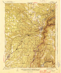
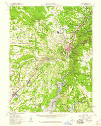
 1914 Folsom1914 Print · USGSThe American River gold country comes alive in this early century survey of the region surrounding Folsom. Researchers can trace the path of the Placerville Branch railroad or locate early industrial sites like the Power House and a large river Dredge.2 unique versions available
 - 1941 Map of Folsom, 1957 Print
 1941 Folsom1957 Print · USGSThe foothills of the Sierra Nevada meet the Central Valley in the early 1940s, showing the river and rail corridors before major reservoirs were built. Researchers can trace the original tracks of the Southern Pacific and locate historic rural hubs like Natoma, Clarksville, and Mormon Island Sch.2 unique versions available
 - 1942 Map of Markham Ravine
 1942 Markham Ravine1942 Print · USGSWestern Placer County was a landscape of busy rail lines and rural schoolhouses in the early 1940s. Genealogists and historians can trace old homesteads near Sheridan, locate the Clay Quarry at Lincoln, or find former community centers like Central Sch.
 - 1944 Map of Auburn
 1944 Auburn1944 Print · USGSThe Placer County foothills in the early 1940s show a landscape of deep river canyons and growing rail towns. Researchers can trace rural school districts like Japanese Sch and old river crossings at Rattlesnake Bridge and Salmon Falls.3 unique versions available
 - 1944 Map of Folsom
 1944 Folsom1944 Print · USGSThe American River region around Folsom thrives in the early 1940s, marked by dredging bars and early rail transport before major reservoirs transformed the valley. Researchers can find many schoolhouses like Mormon Island Sch and landmarks such as the State Prison Represa.2 unique versions available
 - 1947 Map of Sacramento, 1948 Print
 1947 Sacramento1948 Print · USGSThe Sacramento Valley meets the high Sierra during a period of post-war expansion. Trace the historic river delta islands like Grand Island or locate early airfield footprints at McClellan Air Force Base and Mather Air Force Base.2 unique versions available
 - 1948 Map of Sacramento, 1951 Print
 1948 Sacramento1951 Print · USGSPost-war Northern California comes alive in this regional survey, capturing the era of expansion between the Central Valley and the High Sierra. Researchers can trace the rail networks of the Central California Traction and Sacramento Northern RR or locate landmarks like the State Capitol and University of California Davis.
 - 1951 Map of Citrus Heights, 1952 Print
 1951 Citrus Heights1952 Print · USGSNortheast of Sacramento in the early fifties, the landscape was quickly evolving from agricultural ranch lands into bustling suburbs. Genealogists and historians can trace the foundations of Citrus Heights through its early schools like Sylvan Sch and the industrial Dredge Tailings along the American River.3 unique versions available
 - 1953 Map of Pleasant Grove, 1954 Print
 1953 Pleasant Grove1954 Print · USGSThe Sutter and Placer county borderlands are shown here in the mid-twentieth century as a productive landscape of ranches and rail lines. Genealogists and historians can trace family locations near Pleasant Grove, the Alpha Sch, or the small station at Sankey.2 unique versions available
 - 1953 Map of Roseville, 1955 Print
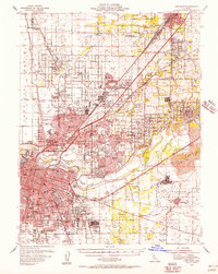
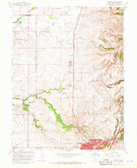
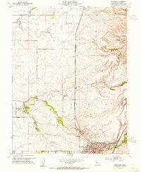 1953 Roseville1955 Print · USGSRoseville was expanding as a major rail hub and agricultural center in the mid-1950s, surrounded by vast orchards and family ranches. Local historians can trace early landholdings such as the W F Fiddyment Ranch and community landmarks like the Public Cem and Woodbridge Sch.2 unique versions available
 - 1953 Map of Lincoln, 1959 Print
 1953 Lincoln1959 Print · USGSMid-century Placer County is captured here during a period of agricultural stability and industrial growth. Researchers can trace family ranching legacies at WF Fiddyment Ranch or explore the clay industry near Clayton and Lincoln.2 unique versions available
 - 1954 Map of Rocklin, 1955 Print
 1954 Rocklin1955 Print · USGSThe Placer County foothills in the mid-fifties show a landscape shaped by the rail and mining industries before the filling of Folsom Lake. Genealogists can trace family footprints near Stallman Corners or research historic operations at the Alabama Mine and Mary Len Mine.2 unique versions available
 - 1954 Map of Folsom, 1955 Print
 1954 Folsom1955 Print · USGSThe American River region undergoes a massive transformation in the mid-fifties as the new Folsom and Nimbus dams begin to reshape the valley. Genealogists and historians can trace the foundations of Orangevale or find the soon-to-be-submerged Mormon Island (Site) and Prairie City (Site).2 unique versions available
 - 1954 Map of Fair Oaks, 1957 Print
 1954 Fair Oaks1957 Print · USGSSacramento and the American River suburbs underwent significant growth during the early Cold War era as military bases and new subdivisions expanded. Genealogists and historians can trace family roots through numerous schools like Grant Union HS, the St Patrick Orphanage, and small communities like Sylvan Corners.2 unique versions available
 - 1954 Map of Auburn, 1959 Print
 1954 Auburn1959 Print · USGSThe Gold Country foothills of Placer and El Dorado Counties are captured here during the mid-fifties, just as the valley floor prepared for the rise of the Folsom Reservoir. Researchers can trace the river's historic mining bars or locate legacy landmarks like the Auburn Rancheria, Bayley House, and Clipper Gap.2 unique versions available
 - 1956 Map of Sacramento
 1956 Sacramento1956 Print · USGSMid-century California unfolds from the delta to the high Sierra, capturing a landscape of growing valley cities and burgeoning military airbases. Genealogists and historians can trace the rail lines and river towns from Woodland to Lodi, or explore the foothill settlements of Placerville and Jackson.2 unique versions available
 - 1957 Map of Sacramento, 1966 Print
 1957 Sacramento1966 Print · USGSIn the mid-twentieth century, the California heartland was a hub of river transport, rail lines, and military airbases. Genealogists and historians can trace the development of Gold Country towns like Angels Camp and Sonora or follow the path of the Southern Pacific RR through the growing suburbs of Sacramento.4 unique versions available
 - 1967 Map of Folsom, 1968 Print
 1967 Folsom1968 Print · USGSThe American River corridor was undergoing rapid transformation in the late sixties as suburban growth met industrial history. Researchers can locate Folsom State Prison, trace the old Prairie City (Site), and see the extensive Dredge Tailings left from gold mining days.4 unique versions available
 - 1967 Map of Pleasant Grove, 1968 Print
 1967 Pleasant Grove1968 Print · USGSThe agricultural heart of the Central Valley at the Sutter and Placer county line comes into focus in this late-sixties survey. Genealogists and historians can trace rail-side settlements like Riego and Sankey or locate landmarks such as the Radio Towers (KFBK).2 unique versions available
 - 1967 Map of Rocklin, 1968 Print
 1967 Rocklin1968 Print · USGSPlacer County's foothill corridor underwent significant transition in the late sixties as traditional rail towns met new suburban growth. Genealogists and historians can trace family-named landmarks like Stallman Corners or locate Placer Ch and the Mary Leh Mine.3 unique versions available
 - 1967 Map of Roseville, 1968 Print
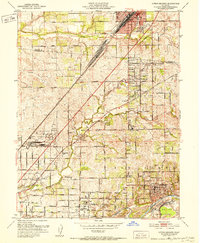
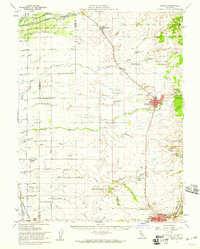
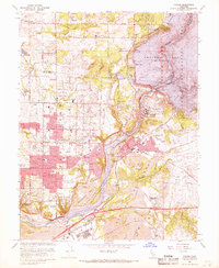
 1967 Roseville1968 Print · USGSRoseville and Rocklin appear during a period of agricultural transition in the late sixties as ranching lands met new suburban growth. Genealogists and researchers can locate family-named properties like the W F Fiddlyment Ranch, the Roseville Cem, and the old Southern Pacific rail line.3 unique versions available
Showing maps 1-25 of 31
Top cities near Roseville
- Sacramento historical maps
- Citrus Heights historical maps
- Folsom historical maps
- Rancho Cordova historical maps
- Rocklin historical maps
- West Sacramento historical maps
See more
Top neighborhoods of Roseville
- The Village historical maps
- Solaire historical maps
- West Park historical maps
- Fiddyment Farm historical maps
Frequently asked questions
- What are the different types of historical maps available for Roseville?
- What is the oldest map of Roseville?
- Where can I purchase historical maps of Roseville for my home or office?
- Where can I download high-res historical maps of Roseville?
- Are there historical topographic maps available for Roseville?
- Is there historical aerial imagery available for Roseville?
- Where are historical maps of Roseville sourced from?