1900s (20th Century) Maps of Bucks Lake, California
Explore 6 historic maps of Bucks Lake from the 1900s (20th Century). These maps offer a rare glimpse into what life looked like during the 1900s — showing old roads, neighborhoods, homes, and landmarks that have changed or disappeared over time.
Whether you're researching your family's past, planning a metal detecting trip, or studying how Bucks Lake's landscape evolved across the 1900s, these high-resolution maps are a powerful tool for exploring the history of this region.
- Focus on a specific era: All maps on this page are from the 1900s, giving you a focused view of this time period.
- See what’s changed: Compare century-old streets, trails, and buildings to today's modern landscape using overlays and satellite layers.
- Research with precision: Use these maps for genealogy, historical research, land use analysis, or educational projects.
- View, download, or print: Maps are fully viewable online in high resolution, and can be downloaded or printed for your own records.
Start exploring Bucks Lake's history through authentic maps from the 1900s. This is your window into the past.
Bucks Lake, CA maps
(6)- 1950 Map of Bucks Lake, 1953 Print
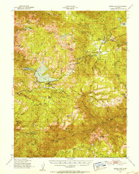 1950 Bucks Lake1953 Print · USGSThe High Sierra timberlands and alpine lakes of Plumas County are captured here just after the mid-century. Researchers can trace early ranching and mining sites like Spanish Ranch, the Pineleaf Mine, and the U C Forestry Camp in Meadow Valley.3 unique versions available
 - 1958 Map of Chico, 1962 Print
 1958 Chico1962 Print · USGSMid-century Northern California comes to life across the Central Valley and high Sierras as the postwar economy transformed the landscape. Trace the rail lines of the Southern Pacific RR, locate family roots near Chico Cem, or explore the early layout of Paradise and Beale Air Force Base.4 unique versions available
 - 1960 Map of Chico
 1960 Chico1960 Print · USGSThe Northern California high country and Sacramento Valley meet in this 1960s-era landscape of mining towns and river settlements. Trace the rail-and-water economy of the gold country through the Empire Mine, Beale Air Force Base, and the Western Pacific Railroad.
 - 1980 Map of Chico
 1980 Chico1980 Print · USGSButte County and the Sierra foothills are shown here in the 1980s as the region's water and timber economies matured. Genealogists and researchers can trace old land grants like Rancho Capay or locate mountain mining sites and settlements such as Cherokee, Magalia, and the Big Bend Mine.2 unique versions available
 - 1980 Map of Haskins Valley
 1980 Haskins Valley1980 Print · USGSHaskins Valley and the high Sierras are depicted in the late 1970s as a landscape of active mining and seasonal ranching. Researchers can trace historic claims like the Robinson Mine and Ontop Mine or locate family-named sites such as Paulson Place.
 - 1994 Map of Haskins Valley, 1999 Print
 1994 Haskins Valley1999 Print · USGSThe Plumas National Forest in the mid-1990s shows a landscape of mountain resorts and active mining claims. Genealogists and historians can trace family sites like Paulson Place or the Fages Ranch and find remote operations such as the Hardquartz Mine.
End of results
Showing maps 1-6 of 6
Frequently asked questions
- What are the different types of historical maps available for Bucks Lake?
- What is the oldest map of Bucks Lake?
- Where can I purchase historical maps of Bucks Lake for my home or office?
- Where can I download high-res historical maps of Bucks Lake?
- Are there historical topographic maps available for Bucks Lake?
- Is there historical aerial imagery available for Bucks Lake?
- Where are historical maps of Bucks Lake sourced from?