1900s (20th Century) Maps of Quincy Junction, California
Explore 7 historic maps of Quincy Junction from the 1900s (20th Century). These maps offer a rare glimpse into what life looked like during the 1900s — showing old roads, neighborhoods, homes, and landmarks that have changed or disappeared over time.
Whether you're researching your family's past, planning a metal detecting trip, or studying how Quincy Junction's landscape evolved across the 1900s, these high-resolution maps are a powerful tool for exploring the history of this region.
- Focus on a specific era: All maps on this page are from the 1900s, giving you a focused view of this time period.
- See what’s changed: Compare century-old streets, trails, and buildings to today's modern landscape using overlays and satellite layers.
- Research with precision: Use these maps for genealogy, historical research, land use analysis, or educational projects.
- View, download, or print: Maps are fully viewable online in high resolution, and can be downloaded or printed for your own records.
Start exploring Quincy Junction's history through authentic maps from the 1900s. This is your window into the past.
Quincy Junction, CA maps
(7)- 1950 Map of Quincy, 1958 Print
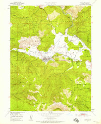 1950 Quincy1958 Print · USGSAmerican Valley in the mid-twentieth century was a vital hub for Plumas County logging and transport. Genealogists and researchers can trace the old footprints of Newtown, locate the Indian Cemetery, and follow the Western Pacific Railroad through Quincy.5 unique versions available
 - 1951 Map of Quincy
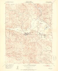 1951 Quincy1951 Print · USGSQuincy and the American Valley are seen here in the early fifties during a period of steady timber and rail activity. Genealogists and historians can locate the Indian Cemetery, trace the Western Pacific Railroad, and find early sites like the Imperial Mine or Pioneer Sch.2 unique versions available
 - 1951 Map of Quincy, 1958 Print
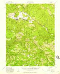 1951 Quincy1958 Print · USGSMid-century Plumas County comes alive through this survey of the American Valley and its surrounding gold-bearing ridges. Researchers can trace the Western Pacific Railroad past historic points like Nelson Point and the Hungarian Placer Mine.3 unique versions available
 - 1958 Map of Chico, 1962 Print
 1958 Chico1962 Print · USGSMid-century Northern California comes to life across the Central Valley and high Sierras as the postwar economy transformed the landscape. Trace the rail lines of the Southern Pacific RR, locate family roots near Chico Cem, or explore the early layout of Paradise and Beale Air Force Base.4 unique versions available
 - 1960 Map of Chico
 1960 Chico1960 Print · USGSThe Northern California high country and Sacramento Valley meet in this 1960s-era landscape of mining towns and river settlements. Trace the rail-and-water economy of the gold country through the Empire Mine, Beale Air Force Base, and the Western Pacific Railroad.
 - 1979 Map of Portola, 1993 Print
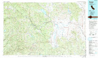 1979 Portola1993 Print · USGSThe northern Sierra Nevada and its timber-and-rail economy are captured here during the late seventies, spanning from the Feather River canyons to the high basins. Researchers can trace the path of the Western Pacific RR and locate historic hubs like Quincy, Portola, and Loyalton.2 unique versions available
 - 1994 Map of Quincy, 1998 Print
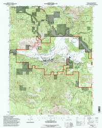 1994 Quincy1998 Print · USGSThe mountain enclave of Quincy and the American Valley are captured here during the mid-nineties, showing the integration of forest management and local industry. Genealogists and historians can locate the County Cemetery, trace the Feather River Route, or find legacy sites like the Newton Mine.
End of results
Showing maps 1-7 of 7
Frequently asked questions
- What are the different types of historical maps available for Quincy Junction?
- What is the oldest map of Quincy Junction?
- Where can I purchase historical maps of Quincy Junction for my home or office?
- Where can I download high-res historical maps of Quincy Junction?
- Are there historical topographic maps available for Quincy Junction?
- Is there historical aerial imagery available for Quincy Junction?
- Where are historical maps of Quincy Junction sourced from?