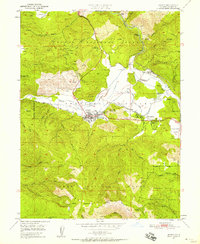
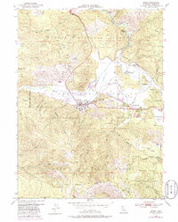
1950 Map of Quincy
USGS Topo · Published 1958About this map
American Valley serves as the focal point of this 1950s survey, where the town of Quincy sits at the intersection of mountain logging and regional commerce. The landscape reveals a complex network of resource extraction and community infrastructure, from the Cedar Mill and multiple mining sites like the Hungarian Placer Mine to essential services such as the County Hospital and Gansner Airport. Settlement patterns are clearly defined by the Western Pacific Railroad which connects Quincy Junction to the broader valley. Local history is deeply embedded in the terrain, marked by the Indian Cemetery and County Cemetery north of the main townsite. The surrounding Plumas National Forest and the Feather River Experimental Forest dominate the high ground, which is etched with numerous ravines and creeks like Spanish Creek and Boyle Ravine.
Find a feature on this map
67 named features on this map. Tap any name to fly to it.
Don’t see what you’re looking for? This feature index may not catch every label — zoom into the map to look around manually.
Map Details
Editions of this 1950 Quincy Map
5 editions found
Other maps of this area

1886 · Honey Lake
USGS Topo · 1:250,000

1886 · Lassen Peak
USGS Topo · 1:250,000

1888 · Bidwell Bar
USGS Topo · 1:125,000

1891 · Bidwell Bar
USGS Topo · 1:125,000

1891 · Downieville
USGS Topo · 1:125,000

1891 · Honey Lake
USGS Topo · 1:250,000

1892 · Lassen Peak
USGS Topo · 1:250,000

1893 · Bidwell Bar
USGS Topo · 1:125,000

1893 · Honey Lake
USGS Topo · 1:250,000

1893 · Downieville
USGS Topo · 1:125,000