Old Maps of Beaumont, California for Genealogy
Trace your family roots with 42 historic maps of Beaumont. These high-res maps reveal old neighborhoods, homesites, landmarks, and streets — helping you uncover where your ancestors lived and how the area evolved over time.
- Explore historic neighborhoods: Identify where your relatives may have lived in the 1800s or 1900s.
- Compare maps over time: Trace the changes in streets, buildings, and landmarks for multi-generational research.
- Perfect for genealogy & ancestry research: Used by family historians and researchers to map out lineage and migration.
These maps are an incredible resource for exploring your personal connection to Beaumont's past.
Beaumont, CA maps
(42)- 1901 Map of Southern California Sheet No. 1
 1901 Southern California Sheet No. 11901 Print · USGSGreater Los Angeles at the dawn of the twentieth century is a landscape of growing citrus towns and a burgeoning rail network. Genealogists and historians can trace the early gridded streets of Hollywood and Pasadena or locate landmarks like Bear Lake and the Cahuilla Indian Reservation.6 unique versions available
 - 1901 Map of San Jacinto
 1901 San Jacinto1901 Print · USGSRiverside County at the dawn of the twentieth century shows a landscape transitioning from tribal lands and mountain reserves to citrus and rail hubs. Genealogists can trace early homesteads and rail stops like Palm Springs Sta. and the grid of Florida or the secluded Kenworthy.9 unique versions available
 - 1901 Map of Elsinore
 1901 Elsinore1901 Print · USGSRiverside and the Alessandro Valley are shown here during a peak of early mining and rail expansion. Genealogists and historians can trace the Southern California RR through Perris or locate the Alberhill Coal Mine and Indian School.8 unique versions available
 - 1904 Map of Southern California Sheet No. 1, 1905 Print
 1904 Southern California Sheet No. 11905 Print · USGSSouthern California at the dawn of the twentieth century shows a landscape of citrus groves and coastal towns connected by rail. Genealogists and historians can trace early settlements like San Juan Capistrano, find remote sites like the Rose Mine, and study the original water systems of the Santa Ana River.2 unique versions available
 - 1942 Map of Banning, 1943 Print
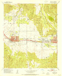
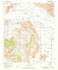
 1942 Banning1943 Print · USGSRiverside County at the start of the 1940s centers on the critical rail and road artery through the San Gorgonio Pass. Genealogists and historians can locate family holdings like Browns Ranch or trace local landmarks such as Gilman Hot Springs and the St Boniface Indian Sch.2 unique versions available
 - 1942 Map of Perris, 1963 Print
 1942 Perris1963 Print · USGSRiverside County at the start of the 1940s was a landscape of rail-connected valley towns and thermal springs. Researchers can trace the early grids of Sunnymead and Moreno or locate historic rural landmarks like Bernasconi Hot Springs and Midland Sch.2 unique versions available
 - 1943 Map of Perris
 1943 Perris1943 Print · USGSWestern Riverside County comes alive in the 1940s, showing the early rail-and-ranch life of the Inland Empire. Trace local heritage through rural schools like Midland Sch and the natural thermal waters at Bernasconi Hot Springs.
 - 1943 Map of Banning, 1952 Print
 1943 Banning1952 Print · USGSRiverside County at the height of the Second World War shows the critical transportation and resort corridor through the San Gorgonio Pass. Researchers can trace the legacy of the St Boniface Indian Sch and the development of Highland Springs Resort alongside the Southern Pacific rail line.
 - 1947 Map of Santa Ana, 1949 Print
 1947 Santa Ana1949 Print · USGSSouthern California is depicted here in the late forties, showing the expansion of the Inland Empire and the Orange County coast. Researchers can trace the early layout of Palm Springs or locate long-standing tribal lands like the Pala Indian Reservation and Rincon Indian Res.
 - 1949 Map of Santa Ana
 1949 Santa Ana1949 Print · USGSSouthern California underwent a profound transformation in the late 1940s as military installations and citrus groves shared the landscape. Researchers can trace early coastal growth at Laguna Beach, military history at Camp Pendleton, and the rail corridors of the Pacific Electric.
 - 1953 Map of Beaumont, 1954 Print
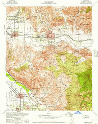
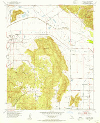
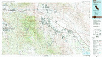
 1953 Beaumont1954 Print · USGSThe San Gorgonio Pass area thrived in the early fifties as a vital transportation and agricultural hub between the peaks. Researchers can trace the mid-century layout of Beaumont and Banning, locating local landmarks like Sunnyslope Cemetery, the Southern Pacific rail line, and St Boniface School.10 unique versions available
 - 1953 Map of El Casco, 1954 Print
 1953 El Casco1954 Print · USGSRiverside County in the early fifties shows a transition from sprawling land grants to organized settlements along the Southern Pacific rail line. Genealogists and local historians can trace the foundations of Calimesa and find long-standing landmarks like Eden Hot Springs and El Casco Lake.3 unique versions available
 - 1953 Map of San Jacinto, 1954 Print
 1953 San Jacinto1954 Print · USGSThe San Jacinto Valley was a vital corridor of water engineering and rail transport in the early fifties. Genealogists and local historians can trace the foundations of San Jacinto and Hemet, along with the Soboba Indian Reservation and Gilman Hot Springs.4 unique versions available
 - 1953 Map of Lakeview, 1955 Print
 1953 Lakeview1955 Print · USGSThe San Jacinto River valley was a landscape of ranches and massive water works in the early fifties. Genealogists and researchers can trace the Colorado River Aqueduct as it passes near Lakeview, the Bar V Ranch, and Juniper Springs.3 unique versions available
 - 1956 Map of Santa Ana
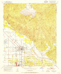
 1956 Santa Ana1956 Print · USGSSouthern California underwent massive mid-century transformation as suburban growth met major military and water projects. Trace the postwar expansion of Santa Ana and Riverside, the layout of Camp Pendleton, and the path of the Colorado River Aqueduct.
 - 1956 Map of Banning, 1961 Print
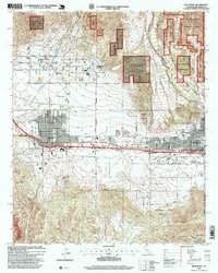
 1956 Banning1961 Print · USGSRiverside County towns and mountain passes are captured here during the mid-1950s. Genealogists and historians can trace the development of Banning, San Jacinto, and Beaumont while locating landmarks like St Boniface Sch and Sunnyslope Cem.2 unique versions available
 - 1959 Map of Santa Ana, 1971 Print
 1959 Santa Ana1971 Print · USGSSouthern California is captured in a decade of transformation, from the Orange County coast to the desert floor. Researchers can trace the mid-century footprints of Camp Pendleton, March Air Force Base, and the original Ortega Highway.3 unique versions available
 - 1960 Map of Santa Ana
 1960 Santa Ana1960 Print · USGSSouthern California's coastal plains and inland deserts meet in this mid-century survey of the burgeoning Orange and Riverside county corridors. Researchers can trace the layout of early freeway systems, find tribal lands like the Soboba Indian Reservation, and locate military landmarks such as March Field.2 unique versions available
 - 1965 Map of Santa Ana
 1965 Santa Ana1965 Print · USGSSouthern California is captured in a decade of rapid growth, showing the coastal expansion from Santa Ana down to Oceanside. Genealogists and historians can trace the mid-century development of places like Garden Grove or the rural reaches of Escondido and the Palomar Observatory.
 - 1967 Map of El Casco, 1968 Print
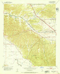
 1967 El Casco1968 Print · USGSRiverside County at the peak of the sixties shows a landscape of developing towns and steep canyon passes. Genealogists and historians can trace Eden Hot Springs, the Southern Pacific rail route, and local landmarks like El Casco Lake or the Forest Lawn Memorial Gardens.6 unique versions available
 - 1967 Map of Lakeview, 1968 Print
 1967 Lakeview1968 Print · USGSLakeview and the surrounding Riverside County foothills are captured here during a period of expanding water infrastructure in the late sixties. Researchers can trace the Colorado River Aqueduct, find the Maze Stone Historical Marker, and locate the Bar V Ranch.4 unique versions available
 - 1983 Map of Santa Ana
 1983 Santa Ana1983 Print · USGSCoastal Orange County meets the Inland Empire in the early eighties as suburban growth accelerates through the SANTA ANA MOUNTAINS. Researchers can trace institutional and military history at MARCH AIR FORCE BASE, locate the Santiago Coal Mine, or find family sites near Fairhaven Cem.
 - 1984 Map of Palm Springs, 1986 Print
 1984 Palm Springs1986 Print · USGSRiverside County’s desert resorts and valley agriculture are captured here in the mid-eighties as modern development expanded across the Coachella Valley. Genealogists and researchers can trace the growth of Palm Springs, locate family land near the Soboba Indian Reservation, or follow the Southern Pacific rail line through Banning.3 unique versions available
 - 1996 Map of San Jacinto, 1999 Print
 1996 San Jacinto1999 Print · USGSSan Jacinto and Hemet appear during a period of significant valley growth in the mid-nineties, framed by the towering peaks of the San Jacinto Mountains. Genealogists and local historians can trace the historic San Jacinto Nuevo y Potrero Grant lines alongside the Soboba Indian Reservation and Gilman Hot Springs.
 - 1996 Map of Beaumont, 1999 Print
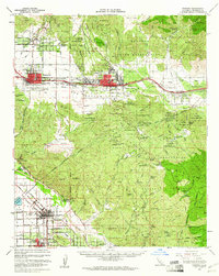
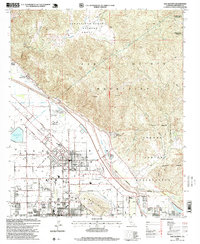
 1996 Beaumont1999 Print · USGSThe San Gorgonio Pass region in the late nineties shows a landscape defined by the arrival of the Southern Pacific and growing suburban grids. Genealogists and local historians can trace family locations through Mt View Cem, Hemmerling School, and the Morongo Indian Reservation.
Showing maps 1-25 of 42
Top cities near Beaumont
- Moreno Valley historical maps
- Menifee historical maps
- Hemet historical maps
- Redlands historical maps
- Highland historical maps
- Perris historical maps
See more
Frequently asked questions
- What are the different types of historical maps available for Beaumont?
- What is the oldest map of Beaumont?
- Where can I purchase historical maps of Beaumont for my home or office?
- Where can I download high-res historical maps of Beaumont?
- Are there historical topographic maps available for Beaumont?
- Is there historical aerial imagery available for Beaumont?
- Where are historical maps of Beaumont sourced from?