1990s Maps of Calimesa, California
Explore 3 historic maps of Calimesa from the 1990s. These maps offer a rare glimpse into what life looked like during the 1990s — showing old roads, neighborhoods, homes, and landmarks that have changed or disappeared over time.
Whether you're researching your family's past, planning a metal detecting trip, or studying how Calimesa's landscape evolved across the 1990s, these high-resolution maps are a powerful tool for exploring the history of this region.
- Focus on a specific era: All maps on this page are from the 1990s, giving you a focused view of this time period.
- See what’s changed: Compare century-old streets, trails, and buildings to today's modern landscape using overlays and satellite layers.
- Research with precision: Use these maps for genealogy, historical research, land use analysis, or educational projects.
- View, download, or print: Maps are fully viewable online in high resolution, and can be downloaded or printed for your own records.
Start exploring Calimesa's history through authentic maps from the 1990s. This is your window into the past.
Calimesa, CA maps
(3)- 1996 Map of Yucaipa, 1999 Print
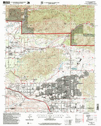 1996 Yucaipa1999 Print · USGSYucaipa and the Inland Empire's eastern edge are captured here during a period of significant growth in the late nineties. Local researchers can trace residential expansion around Calimesa, the grounds of Crafton Hills College, and landmarks like Morton Peak.
 - 1996 Map of Forest Falls, 1999 Print
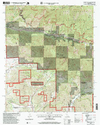 1996 Forest Falls1999 Print · USGSSan Bernardino mountain communities like Forest Falls and Oak Glen are shown at the close of the twentieth century. Researchers can locate the Fallsvale Sch, the Washington Monument, and historic water infrastructure along Mill Creek.
 - 1996 Map of Beaumont, 1999 Print
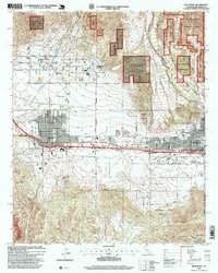 1996 Beaumont1999 Print · USGSThe San Gorgonio Pass region in the late nineties shows a landscape defined by the arrival of the Southern Pacific and growing suburban grids. Genealogists and local historians can trace family locations through Mt View Cem, Hemmerling School, and the Morongo Indian Reservation.
End of results
Showing maps 1-3 of 3
Top cities near Calimesa
- Riverside historical maps
- Moreno Valley historical maps
- Menifee historical maps
- Hemet historical maps
- Redlands historical maps
- Highland historical maps
See more
Frequently asked questions
- What are the different types of historical maps available for Calimesa?
- What is the oldest map of Calimesa?
- Where can I purchase historical maps of Calimesa for my home or office?
- Where can I download high-res historical maps of Calimesa?
- Are there historical topographic maps available for Calimesa?
- Is there historical aerial imagery available for Calimesa?
- Where are historical maps of Calimesa sourced from?