1940s Maps of Desert Beach, California
Explore 2 historic maps of Desert Beach from the 1940s. These maps offer a rare glimpse into what life looked like during the 1940s — showing old roads, neighborhoods, homes, and landmarks that have changed or disappeared over time.
Whether you're researching your family's past, planning a metal detecting trip, or studying how Desert Beach's landscape evolved across the 1940s, these high-resolution maps are a powerful tool for exploring the history of this region.
- Focus on a specific era: All maps on this page are from the 1940s, giving you a focused view of this time period.
- See what’s changed: Compare century-old streets, trails, and buildings to today's modern landscape using overlays and satellite layers.
- Research with precision: Use these maps for genealogy, historical research, land use analysis, or educational projects.
- View, download, or print: Maps are fully viewable online in high resolution, and can be downloaded or printed for your own records.
Start exploring Desert Beach's history through authentic maps from the 1940s. This is your window into the past.
Desert Beach, CA maps
(2)- 1940 Map of Cottonwood Spring, 1956 Print
 1940 Cottonwood Spring1956 Print · USGSRiverside County in the early 1940s reveals a desert landscape in transition as massive water projects like the Colorado River Aqueduct and Coachella Canal take shape. Genealogists and historians can trace rail-side stops like Mortmar and Desert Camp near the Salton Sea shore.
 - 1944 Map of Cottonwood Spring
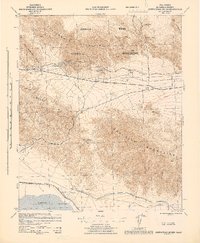 1944 Cottonwood Spring1944 Print · USGSThe Colorado Desert in the mid-1940s is captured here, showing the early development of the Salton Sea shoreline. Trace the path of the Coachella Canal or locate desert landmarks like Cottonwood Spring and Cactus City.
End of results
Showing maps 1-2 of 2
Top cities near Desert Beach
Frequently asked questions
- What are the different types of historical maps available for Desert Beach?
- What is the oldest map of Desert Beach?
- Where can I purchase historical maps of Desert Beach for my home or office?
- Where can I download high-res historical maps of Desert Beach?
- Are there historical topographic maps available for Desert Beach?
- Is there historical aerial imagery available for Desert Beach?
- Where are historical maps of Desert Beach sourced from?