1990s Maps of Thomas Mountain, California
Explore 1 historic maps of Thomas Mountain from the 1990s. These maps offer a rare glimpse into what life looked like during the 1990s — showing old roads, neighborhoods, homes, and landmarks that have changed or disappeared over time.
Whether you're researching your family's past, planning a metal detecting trip, or studying how Thomas Mountain's landscape evolved across the 1990s, these high-resolution maps are a powerful tool for exploring the history of this region.
- Focus on a specific era: All maps on this page are from the 1990s, giving you a focused view of this time period.
- See what’s changed: Compare century-old streets, trails, and buildings to today's modern landscape using overlays and satellite layers.
- Research with precision: Use these maps for genealogy, historical research, land use analysis, or educational projects.
- View, download, or print: Maps are fully viewable online in high resolution, and can be downloaded or printed for your own records.
Start exploring Thomas Mountain's history through authentic maps from the 1990s. This is your window into the past.
Thomas Mountain, CA maps
(1)- 1996 Map of Anza, 1999 Print
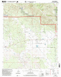 1996 Anza1999 Print · USGSThe high plateaus of Riverside County come alive in the mid-nineties, showing the rural character of the Cahuilla Indian Reservation and Anza. Genealogists and historians can trace the local landscape through the Cahuilla Cemetery, Hamilton School, and the remote Magee Spring.
End of results
Showing maps 1-1 of 1
Top cities near Thomas Mountain
- Cathedral City historical maps
- Palm Desert historical maps
- Palm Springs historical maps
- Rancho Mirage historical maps
- Idyllwild historical maps
- Mountain Center historical maps
Frequently asked questions
- What are the different types of historical maps available for Thomas Mountain?
- What is the oldest map of Thomas Mountain?
- Where can I purchase historical maps of Thomas Mountain for my home or office?
- Where can I download high-res historical maps of Thomas Mountain?
- Are there historical topographic maps available for Thomas Mountain?
- Is there historical aerial imagery available for Thomas Mountain?
- Where are historical maps of Thomas Mountain sourced from?