Old Maps of Cosumne, California for Hiking & Exploration
Hike through history with 13 historic maps of Cosumne. Explore old trails, ghost towns, and forgotten backroads — perfect for outdoor adventurers and local explorers.
- Rediscover forgotten places: Map out old mining camps, roads, and footpaths that no longer exist on modern maps.
- Layer with modern tools: Combine with LiDAR or satellite views to plan hikes through historical terrain.
- Made for exploration: Popular among hikers, overlanders, and local history lovers.
Use these maps to find adventure and explore the hidden past of Cosumne.
Cosumne, CA maps
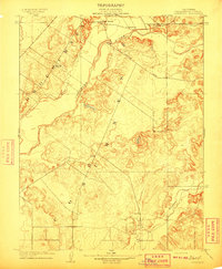
(13)- 1894 Map of Lodi
 1894 Lodi1894 Print · USGSThe northern Central Valley and Sierra foothills come alive in the late nineteenth century as railroads reshape the landscape. Local historians can trace early transit hubs like Lodi and Galt alongside rural landmarks like Alabama House and Michigan Bar.3 unique versions available
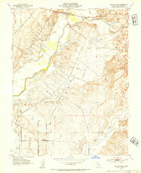
 - 1909 Map of Cosumnes
 1909 Cosumnes1909 Print · USGSSacramento County at the dawn of the twentieth century reveals a landscape of ranching and riverine agriculture. Family historians can locate early educational hubs like Rhoads School and established roadside stops such as the noted Slough House.2 unique versions available
 - 1947 Map of Sacramento, 1948 Print
 1947 Sacramento1948 Print · USGSThe Sacramento Valley meets the high Sierra during a period of post-war expansion. Trace the historic river delta islands like Grand Island or locate early airfield footprints at McClellan Air Force Base and Mather Air Force Base.2 unique versions available
 - 1948 Map of Sacramento, 1951 Print
 1948 Sacramento1951 Print · USGSPost-war Northern California comes alive in this regional survey, capturing the era of expansion between the Central Valley and the High Sierra. Researchers can trace the rail networks of the Central California Traction and Sacramento Northern RR or locate landmarks like the State Capitol and University of California Davis.
 - 1953 Map of Sloughhouse, 1954 Print
 1953 Sloughhouse1954 Print · USGSThe Cosumnes River valley and its surrounding ranchlands are captured here in the early fifties, showing a rural landscape defined by historic land grants. Genealogists and historians can trace the foundations of Sloughhouse, Wilton, and local schools like Lee School.2 unique versions available
 - 1956 Map of Sacramento
 1956 Sacramento1956 Print · USGSMid-century California unfolds from the delta to the high Sierra, capturing a landscape of growing valley cities and burgeoning military airbases. Genealogists and historians can trace the rail lines and river towns from Woodland to Lodi, or explore the foothill settlements of Placerville and Jackson.2 unique versions available
 - 1957 Map of Sacramento, 1966 Print
 1957 Sacramento1966 Print · USGSIn the mid-twentieth century, the California heartland was a hub of river transport, rail lines, and military airbases. Genealogists and historians can trace the development of Gold Country towns like Angels Camp and Sonora or follow the path of the Southern Pacific RR through the growing suburbs of Sacramento.4 unique versions available
 - 1968 Map of Sloughhouse, 1970 Print
 1968 Sloughhouse1970 Print · USGSSacramento County's rural ranching and orchard lands are preserved here during the late sixties, showing the transition from historic land grants to organized agricultural parcels. Genealogists and local historians can locate the Rhoades School, trace the Central California Traction line near Walmort, or find family landmarks along Tavernor Road.4 unique versions available
 - 1993 Map of Lodi, 1994 Print
 1993 Lodi1994 Print · USGSNorthern California's delta country and the growing Central Valley corridors are captured here in the early nineties. Genealogists and historians can trace the intricate island tracts, old railroad lines like the Sacramento Northern RR, and established local landmarks including the Lodi Memorial Cemetery and University of the Pacific.2 unique versions available
 - 2012 Map of Sloughhouse, 2012 Print
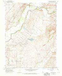
 2012 Sloughhouse2012 Print · USGSCovers Cosumne, including Walmort, Sloughhouse, and other nearby areas
 - 2015 Map of Sloughhouse, 2015 Print
 2015 Sloughhouse2015 Print · USGSCovers Cosumne, including Walmort, Sloughhouse, and other nearby areas
 - 2018 Map of Sloughhouse, 2018 Print
 2018 Sloughhouse2018 Print · USGSCovers Cosumne, including Walmort, Sloughhouse, and other nearby areas
 - 2022 Map of Sloughhouse, 2022 Print
 2022 Sloughhouse2022 Print · USGSThe rural Sacramento Valley is captured here in the early 2020s as ranching traditions and private aviation define the landscape. Researchers can trace land patterns around Wilton and locate several private airstrips like Lucchetti Ranch Airport and Alta Mesa Airpark.
End of results
Showing maps 1-13 of 13
Top cities near Cosumne
- Sacramento historical maps
- Elk Grove historical maps
- Roseville historical maps
- Citrus Heights historical maps
- Folsom historical maps
- Rancho Cordova historical maps
See more
Frequently asked questions
- What are the different types of historical maps available for Cosumne?
- What is the oldest map of Cosumne?
- Where can I purchase historical maps of Cosumne for my home or office?
- Where can I download high-res historical maps of Cosumne?
- Are there historical topographic maps available for Cosumne?
- Is there historical aerial imagery available for Cosumne?
- Where are historical maps of Cosumne sourced from?