1900s (20th Century) Maps of Galt, California
Explore 14 historic maps of Galt from the 1900s (20th Century). These maps offer a rare glimpse into what life looked like during the 1900s — showing old roads, neighborhoods, homes, and landmarks that have changed or disappeared over time.
Whether you're researching your family's past, planning a metal detecting trip, or studying how Galt's landscape evolved across the 1900s, these high-resolution maps are a powerful tool for exploring the history of this region.
- Focus on a specific era: All maps on this page are from the 1900s, giving you a focused view of this time period.
- See what’s changed: Compare century-old streets, trails, and buildings to today's modern landscape using overlays and satellite layers.
- Research with precision: Use these maps for genealogy, historical research, land use analysis, or educational projects.
- View, download, or print: Maps are fully viewable online in high resolution, and can be downloaded or printed for your own records.
Start exploring Galt's history through authentic maps from the 1900s. This is your window into the past.
Galt, CA maps
(14)- 1910 Map of Woodbridge
 1910 Woodbridge1910 Print · USGSSan Joaquin and Sacramento counties are captured here at the height of their early rail-and-river era. Genealogists and historians can trace the early streets of Lodi, the riverside blocks of Woodbridge, and rural landmarks like North School and Tracy Lake.2 unique versions available
 - 1910 Map of Galt
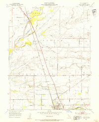
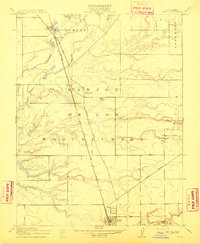 1910 Galt1910 Print · USGSGalt and the surrounding Sacramento Valley are captured here in the early twentieth century as the railroad transformed rural life. Genealogists and local historians can trace the early rail stops at McConnell and Arno or locate the historic Arno School.2 unique versions available
 - 1939 Map of Lodi, 1957 Print
 1939 Lodi1957 Print · USGSThe San Joaquin Delta during the late 1930s shows a landscape of reclaimed islands and a bustling rail-and-river economy. Genealogists and historians can trace old rural school districts like Ray District Sch and landmarks such as the New Hope Migratory Labor Camp.2 unique versions available
 - 1941 Map of Franklin, 1942 Print
 1941 Franklin1942 Print · USGSSacramento and San Joaquin counties are depicted here in the early 1940s, highlighting a vital agricultural and rail corridor. Researchers can trace family-named school districts and early industry like the Bradford Winery, Hicksville, and the Sacramento Co Old Mens Home.
 - 1942 Map of Lodi
 1942 Lodi1942 Print · USGSThe San Joaquin delta region thrives as a complex network of reclaimed islands and sloughs in the early 1940s. Genealogists and historians can trace the foundations of local society through Thornton Migratory Labor Camp, Liberty School, and the busy Mokelumne River landings.
 - 1947 Map of Sacramento, 1948 Print
 1947 Sacramento1948 Print · USGSThe Sacramento Valley meets the high Sierra during a period of post-war expansion. Trace the historic river delta islands like Grand Island or locate early airfield footprints at McClellan Air Force Base and Mather Air Force Base.2 unique versions available
 - 1948 Map of Sacramento, 1951 Print
 1948 Sacramento1951 Print · USGSPost-war Northern California comes alive in this regional survey, capturing the era of expansion between the Central Valley and the High Sierra. Researchers can trace the rail networks of the Central California Traction and Sacramento Northern RR or locate landmarks like the State Capitol and University of California Davis.
 - 1953 Map of Lodi North
 1953 Lodi North1953 Print · USGSNorthern San Joaquin County agriculture is captured here in the early fifties as the region's viticulture and rail networks flourished. Researchers can trace the layout of Lodi, find the Lafayette Sch (Abandoned), or follow the Southern Pacific through Acampo.2 unique versions available
 - 1953 Map of Galt, 1954 Print
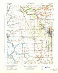
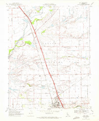
 1953 Galt1954 Print · USGSAgricultural life in central California flourished during the early fifties along the steel rails of the Southern Pacific. Genealogists and local historians can trace the rural landscape from Galt to McConnell, locating the Hicksville Cemetery and the Arno School.2 unique versions available
 - 1956 Map of Sacramento
 1956 Sacramento1956 Print · USGSMid-century California unfolds from the delta to the high Sierra, capturing a landscape of growing valley cities and burgeoning military airbases. Genealogists and historians can trace the rail lines and river towns from Woodland to Lodi, or explore the foothill settlements of Placerville and Jackson.2 unique versions available
 - 1957 Map of Sacramento, 1966 Print
 1957 Sacramento1966 Print · USGSIn the mid-twentieth century, the California heartland was a hub of river transport, rail lines, and military airbases. Genealogists and historians can trace the development of Gold Country towns like Angels Camp and Sonora or follow the path of the Southern Pacific RR through the growing suburbs of Sacramento.4 unique versions available
 - 1968 Map of Lodi North, 1972 Print
 1968 Lodi North1972 Print · USGSSan Joaquin County agriculture and the city of Lodi thrive in the late sixties as the region's rail and irrigation networks reach full maturity. Researchers can locate vanished rural landmarks and family sites like Houston School, Liberty Cemetery, and Linds Airport.2 unique versions available
 - 1968 Map of Galt, 1972 Print
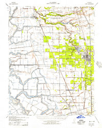
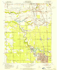
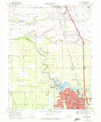
 1968 Galt1972 Print · USGSThe Sacramento and San Joaquin county border country comes alive in the late sixties as the town of Galt expands along the Southern Pacific line. Genealogists can trace family landmarks like the Hicksville Cemetery or the community at Twin Cities.3 unique versions available
 - 1993 Map of Lodi, 1994 Print
 1993 Lodi1994 Print · USGSNorthern California's delta country and the growing Central Valley corridors are captured here in the early nineties. Genealogists and historians can trace the intricate island tracts, old railroad lines like the Sacramento Northern RR, and established local landmarks including the Lodi Memorial Cemetery and University of the Pacific.2 unique versions available
End of results
Showing maps 1-14 of 14
Top cities near Galt
Top neighborhoods of Galt
Frequently asked questions
- What are the different types of historical maps available for Galt?
- What is the oldest map of Galt?
- Where can I purchase historical maps of Galt for my home or office?
- Where can I download high-res historical maps of Galt?
- Are there historical topographic maps available for Galt?
- Is there historical aerial imagery available for Galt?
- Where are historical maps of Galt sourced from?