1960s Maps of Golf Course Terrace, Sacramento
Explore 3 historic maps of Golf Course Terrace from the 1960s. These maps offer a rare glimpse into what life looked like during the 1960s — showing old roads, neighborhoods, homes, and landmarks that have changed or disappeared over time.
Whether you're researching your family's past, planning a metal detecting trip, or studying how Golf Course Terrace's landscape evolved across the 1960s, these high-resolution maps are a powerful tool for exploring the history of this region.
- Focus on a specific era: All maps on this page are from the 1960s, giving you a focused view of this time period.
- See what’s changed: Compare century-old streets, trails, and buildings to today's modern landscape using overlays and satellite layers.
- Research with precision: Use these maps for genealogy, historical research, land use analysis, or educational projects.
- View, download, or print: Maps are fully viewable online in high resolution, and can be downloaded or printed for your own records.
Start exploring Golf Course Terrace's history through authentic maps from the 1960s. This is your window into the past.
Golf Course Terrace, Sacramento maps
(3)- 1967 Map of Sacramento East, 1969 Print
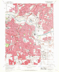 1967 Sacramento East1969 Print · USGSMid-century Sacramento is captured here during a period of rapid suburban growth and industrial strength. Researchers can trace family roots through numerous local landmarks, including St Patricks Orphanage, Sutters Fort St Hist Mon, and the Sacramento Army Depot.3 unique versions available
 - 1967 Map of Clarksburg, 1969 Print
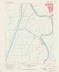 1967 Clarksburg1969 Print · USGSThe Sacramento Delta comes to life in the late sixties as a busy landscape of river commerce and rail transport. Genealogists and historians can trace the foundations of Clarksburg, locate the Pony Express Sch, and explore the reach of the Sacramento Northern railroad.5 unique versions available
 - 1968 Map of Florin, 1970 Print
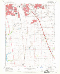 1968 Florin1970 Print · USGSSacramento's southern suburban fringe meets the rural valley floor in the late sixties. Researchers can trace the development of Florin, locate family plots at East Lawn Southgate Cem, or follow the rail lines of the Western Pacific toward Franklin.3 unique versions available
End of results
Showing maps 1-3 of 3
Frequently asked questions
- What are the different types of historical maps available for Golf Course Terrace?
- What is the oldest map of Golf Course Terrace?
- Where can I purchase historical maps of Golf Course Terrace for my home or office?
- Where can I download high-res historical maps of Golf Course Terrace?
- Are there historical topographic maps available for Golf Course Terrace?
- Is there historical aerial imagery available for Golf Course Terrace?
- Where are historical maps of Golf Course Terrace sourced from?