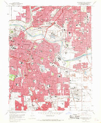
1967 Map of Sacramento East
USGS Topo · Published 1969About this map
Sacramento serves as the focal point of this late 1960s survey, revealing a dense urban core anchored by the State Capitol and the landmark Sutters Fort St Hist Mon. The city's mid-century expansion is evident in the sprawling residential developments of Fruitridge Manor and Arden Town, which contrast with the industrial and transit corridors defined by the Southern Pacific and Western Pacific railroads. The American River carves through the landscape, bordered by numerous recreational sites like Discovery Park and the California State Exposition grounds.
Find a feature on this map
156 named features on this map. Tap any name to fly to it.
Don’t see what you’re looking for? This feature index may not catch every label — zoom into the map to look around manually.
Map Details
Editions of this 1967 Sacramento East Map
3 editions found
Other maps of this area

1891 · Sacramento
USGS Topo · 1:125,000

1892 · Sacramento
USGS Topo · 1:125,000

1893 · Sacramento
USGS Topo · 1:125,000

1894 · Lodi
USGS Topo · 1:125,000

1902 · Fairoaks
USGS Topo · 1:62,500

1907 · Davisville
USGS Topo · 1:62,500

1908 · Courtland
USGS Topo · 1:62,500

1909 · Elk Grove
USGS Topo · 1:31,680

1909 · Florin
USGS Topo · 1:31,680

1911 · Brighton
USGS Topo · 1:31,680