
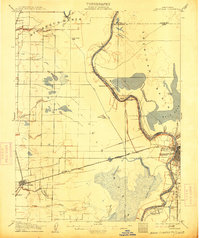
1907 Map of Davisville
USGS Topo · Published 1907About this map
The Sacramento River meanders through a landscape defined by seasonal sloughs and early reclamation efforts at the dawn of the 20th century. This 1907 survey captures the agricultural and transit-oriented development of the region before modern flood control reshaped the basin. The town of Davisville sits along the Southern Pacific R.R., serving as a focal point for the western interior, while the eastern edge of the map shows the burgeoning riverfront activity of Sacramento and the Washington Broderick P.O.
Find a feature on this map
54 named features on this map. Tap any name to fly to it.
Don’t see what you’re looking for? This feature index may not catch every label — zoom into the map to look around manually.
Map Details
Editions of this 1907 Davisville Map
2 editions found
Other maps of this area

1891 · Sacramento
USGS Topo · 1:125,000

1892 · Sacramento
USGS Topo · 1:125,000

1893 · Sacramento
USGS Topo · 1:125,000

1894 · Lodi
USGS Topo · 1:125,000

1902 · Fairoaks
USGS Topo · 1:62,500

1907 · Dunnigan
USGS Topo · 1:62,500

1907 · Woodland
USGS Topo · 1:62,500

1908 · Vacaville
USGS Topo · 1:62,500

1908 · Courtland
USGS Topo · 1:62,500

1909 · Florin
USGS Topo · 1:31,680