Old Maps of Pocket, Sacramento for Academic Research
Study the evolution of Pocket with 20 high-resolution historic maps. Whether you're teaching, researching, or modeling changes in land use, these maps provide essential visual documentation of urban, environmental, and geographic change.
- Analyze long-term change: Track patterns in development, transportation, and natural features.
- Ideal for environmental or urban studies: Support academic projects with primary historical map data.
- Use in the classroom or lab: Educators and researchers rely on these maps to bring historical context to life.
These maps are a powerful tool for teaching, research, and visualizing how Pocket has changed over the decades.
Pocket, Sacramento maps
(20)- 1907 Map of Davisville
 1907 Davisville1907 Print · USGSYolo and Sacramento counties are captured here at a pivot point for river transit and rail growth. Researchers can trace early rural life via the Lisbon School, Taylor Monument Datey's Ferry, and the original footprint of Davisville.2 unique versions available
 - 1908 Map of Courtland
 1908 Courtland1908 Print · USGSThe Sacramento Delta at the dawn of the twentieth century was a landscape of fertile river islands and vital waterborne transit. Genealogists and historians can trace the early footprints of Courtland, Clarksburg, and Freeport, or locate landmarks like the Free County Ferry and Indian Mound.3 unique versions available
 - 1916 Map of Lovdal
 1916 Lovdal1916 Print · USGSNear the confluence of the American and Sacramento Rivers in the early 1900s, this area shows a landscape defined by levees and early rail lines. Genealogists and historians can locate the Lisbon School, the Washington Broderick P O, and industry at the Brickyard.
 - 1916 Map of Babel Slough
 1916 Babel Slough1916 Print · USGSYolo and Sacramento counties meet along the river in the early twentieth century, showing a landscape defined by water and new reclamation canals. Genealogists and local historians can trace riverfront settlements at Clarksburg and Freeport, find the Free County Ferry, and locate the Indian Mound near Big Lake.
 - 1947 Map of Sacramento, 1948 Print
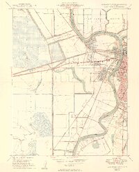
 1947 Sacramento1948 Print · USGSThe Sacramento Valley meets the high Sierra during a period of post-war expansion. Trace the historic river delta islands like Grand Island or locate early airfield footprints at McClellan Air Force Base and Mather Air Force Base.2 unique versions available
 - 1948 Map of Sacramento, 1951 Print
 1948 Sacramento1951 Print · USGSPost-war Northern California comes alive in this regional survey, capturing the era of expansion between the Central Valley and the High Sierra. Researchers can trace the rail networks of the Central California Traction and Sacramento Northern RR or locate landmarks like the State Capitol and University of California Davis.
 - 1948 Map of Sacramento West, 1958 Print
 1948 Sacramento West1958 Print · USGSYolo County and the western edge of the state capital are seen here in the late forties during a period of rapid post-war growth. Genealogists and historians can trace neighborhood development in Bryte and Broderick or locate landmarks like Peethill and the Yolo Causeway.
 - 1949 Map of Sacramento West
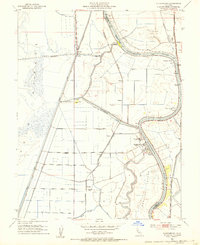
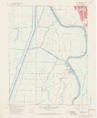
 1949 Sacramento West1949 Print · USGSWest Sacramento and the neighboring river communities are documented here just after the war, showing the vital levee systems and rail lines of Yolo County. Genealogists and historians can trace Bryte, Broderick, and early neighborhood sites like Westacre Sch.2 unique versions available
 - 1952 Map of Clarksburg, 1954 Print
 1952 Clarksburg1954 Print · USGSThe Sacramento River delta comes alive in the early 1950s, showing the intersection of heavy industry and ancient landmarks. Trace the agricultural roots of the region through the Sugar Beet Plant, find the Indian Mound, or locate the vanished stops of the Southern Pacific railroad.2 unique versions available
 - 1952 Map of Courtland, 1959 Print
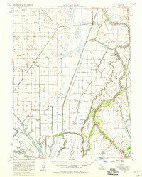 1952 Courtland1959 Print · USGSThe Sacramento Delta comes alive in the early fifties, showing a landscape defined by river commerce and sprawling ranch holdings. Family researchers can locate Tremont Cem, Liberty Sch, and long-established properties like Glide Ranch and Maxwell Ranch.3 unique versions available
 - 1954 Map of Davis, 1956 Print
 1954 Davis1956 Print · USGSMid-century Davis and West Sacramento are shown during a period of major infrastructure growth, with the Sacramento Deep Water Channel still under construction. Genealogists and researchers can trace local landmarks like Davis Cem, Capitol Sky Park, and rural schools such as Taylor Monument Sch.2 unique versions available
 - 1956 Map of Sacramento
 1956 Sacramento1956 Print · USGSMid-century California unfolds from the delta to the high Sierra, capturing a landscape of growing valley cities and burgeoning military airbases. Genealogists and historians can trace the rail lines and river towns from Woodland to Lodi, or explore the foothill settlements of Placerville and Jackson.2 unique versions available
 - 1957 Map of Sacramento, 1966 Print
 1957 Sacramento1966 Print · USGSIn the mid-twentieth century, the California heartland was a hub of river transport, rail lines, and military airbases. Genealogists and historians can trace the development of Gold Country towns like Angels Camp and Sonora or follow the path of the Southern Pacific RR through the growing suburbs of Sacramento.4 unique versions available
 - 1967 Map of Sacramento West, 1968 Print
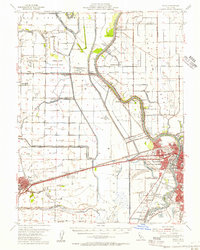
 1967 Sacramento West1968 Print · USGSGreater Sacramento and its industrial waterfront come alive in this mid-century survey of the river and rail networks. Genealogists and historians can trace the growth of West Sacramento neighborhoods, the Port of Sacramento facilities, and schools like Holy Cross Sch.3 unique versions available
 - 1967 Map of Clarksburg, 1969 Print
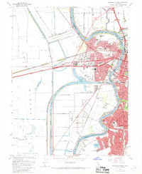
 1967 Clarksburg1969 Print · USGSThe Sacramento Delta comes to life in the late sixties as a busy landscape of river commerce and rail transport. Genealogists and historians can trace the foundations of Clarksburg, locate the Pony Express Sch, and explore the reach of the Sacramento Northern railroad.5 unique versions available
 - 1992 Map of Sacramento West, 1997 Print
 1992 Sacramento West1997 Print · USGSSacramento and its western neighbor are seen here in the early 1990s as the riverfront continued to transition from industry to preservation. Researchers can trace the massive Deep Water Ship Channel and find local landmarks like Old Sacramento State Historical Park and William Land Park.
 - 1993 Map of Lodi, 1994 Print
 1993 Lodi1994 Print · USGSNorthern California's delta country and the growing Central Valley corridors are captured here in the early nineties. Genealogists and historians can trace the intricate island tracts, old railroad lines like the Sacramento Northern RR, and established local landmarks including the Lodi Memorial Cemetery and University of the Pacific.2 unique versions available
 - 1994 Map of Sacramento
 1994 Sacramento1994 Print · USGSThe Sacramento valley was a landscape of massive flood control and military aviation during the mid-nineties. Researchers can trace the complex network of the Yolo Bypass and the Sacramento River alongside McClellan Air Force Base and Zamora.2 unique versions available
 - 2022 Map of Clarksburg, 2022 Print
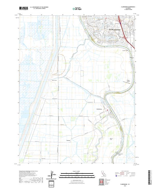 2022 Clarksburg2022 Print · USGSThe riverfront town of Clarksburg and the southern edge of Sacramento are captured in this modern survey of the Sacramento Valley. Researchers can trace the engineering of the Sacramento River Deep Water Ship Channel and find local landmarks like Freeport, Elk Slough, and the Borges - Clarksburg Airport.
 - 2023 Map of Sacramento West, 2023 Print
 2023 Sacramento West2023 Print · USGSThe riverfront and industrial districts of Yolo and Sacramento Counties are shown here in the 2020s, revealing a landscape defined by massive shipping channels and urban growth. Researchers can trace historic neighborhoods like Broderick and Bryte or locate resting places at the Sacramento City Cem and Odd Fellows Lawn Cem.
End of results
Showing maps 1-20 of 20
Frequently asked questions
- What are the different types of historical maps available for Pocket?
- What is the oldest map of Pocket?
- Where can I purchase historical maps of Pocket for my home or office?
- Where can I download high-res historical maps of Pocket?
- Are there historical topographic maps available for Pocket?
- Is there historical aerial imagery available for Pocket?
- Where are historical maps of Pocket sourced from?