1960s Maps of The Elements at Sterling Meadows, Sacramento County
Explore 2 historic maps of The Elements at Sterling Meadows from the 1960s. These maps offer a rare glimpse into what life looked like during the 1960s — showing old roads, neighborhoods, homes, and landmarks that have changed or disappeared over time.
Whether you're researching your family's past, planning a metal detecting trip, or studying how The Elements at Sterling Meadows's landscape evolved across the 1960s, these high-resolution maps are a powerful tool for exploring the history of this region.
- Focus on a specific era: All maps on this page are from the 1960s, giving you a focused view of this time period.
- See what’s changed: Compare century-old streets, trails, and buildings to today's modern landscape using overlays and satellite layers.
- Research with precision: Use these maps for genealogy, historical research, land use analysis, or educational projects.
- View, download, or print: Maps are fully viewable online in high resolution, and can be downloaded or printed for your own records.
Start exploring The Elements at Sterling Meadows's history through authentic maps from the 1960s. This is your window into the past.
The Elements at Sterling Meadows, Sacramento County maps
(2)- 1968 Map of Florin, 1970 Print
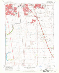 1968 Florin1970 Print · USGSSacramento's southern suburban fringe meets the rural valley floor in the late sixties. Researchers can trace the development of Florin, locate family plots at East Lawn Southgate Cem, or follow the rail lines of the Western Pacific toward Franklin.3 unique versions available
 - 1968 Map of Elk Grove, 1970 Print
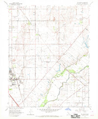 1968 Elk Grove1970 Print · USGSElk Grove and the surrounding Sacramento Valley lowlands are captured here in the late sixties as the area maintained its deep agricultural roots. Genealogists and local historians can trace family locations near Sheldon, Wilton, and landmarks like the Union Cem or Pleasant Grove Sch.6 unique versions available
End of results
Showing maps 1-2 of 2
Frequently asked questions
- What are the different types of historical maps available for The Elements at Sterling Meadows?
- What is the oldest map of The Elements at Sterling Meadows?
- Where can I purchase historical maps of The Elements at Sterling Meadows for my home or office?
- Where can I download high-res historical maps of The Elements at Sterling Meadows?
- Are there historical topographic maps available for The Elements at Sterling Meadows?
- Is there historical aerial imagery available for The Elements at Sterling Meadows?
- Where are historical maps of The Elements at Sterling Meadows sourced from?