1980s Maps of Amboy, California
Explore 3 historic maps of Amboy from the 1980s. These maps offer a rare glimpse into what life looked like during the 1980s — showing old roads, neighborhoods, homes, and landmarks that have changed or disappeared over time.
Whether you're researching your family's past, planning a metal detecting trip, or studying how Amboy's landscape evolved across the 1980s, these high-resolution maps are a powerful tool for exploring the history of this region.
- Focus on a specific era: All maps on this page are from the 1980s, giving you a focused view of this time period.
- See what’s changed: Compare century-old streets, trails, and buildings to today's modern landscape using overlays and satellite layers.
- Research with precision: Use these maps for genealogy, historical research, land use analysis, or educational projects.
- View, download, or print: Maps are fully viewable online in high resolution, and can be downloaded or printed for your own records.
Start exploring Amboy's history through authentic maps from the 1980s. This is your window into the past.
Amboy, CA maps
(3)- 1981 Map of Needles, 1987 Print
 1981 Needles1987 Print · USGSThe High Desert and Colorado River valley are seen here in the early 1980s through the unique lens of satellite imagery. Trace the isolated outposts of the AT & SF railroad at Goffs and Essex, or explore the sprawling shores of Lake Havasu.
 - 1985 Map of Amboy
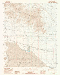 1985 Amboy1985 Print · USGSIn the mid-1980s, the desert crossroads of San Bernardino County revolved around the mineral wealth of the dry lake basins. Trace the industrial footprint of Saltus and Amboy through their Salt Evaporators, Mines Prospect, and desert 4WD tracks.
 - 1985 Map of Amboy
 1985 Amboy1985 Print · USGSSan Bernardino County in the mid-eighties shows a high desert landscape defined by the Atchison Topeka and Santa Fe railroad and remote mining camps. Researchers can trace the desert road network connecting Amboy and Essex or locate historic shafts like the Silver King Mine.
End of results
Showing maps 1-3 of 3
Frequently asked questions
- What are the different types of historical maps available for Amboy?
- What is the oldest map of Amboy?
- Where can I purchase historical maps of Amboy for my home or office?
- Where can I download high-res historical maps of Amboy?
- Are there historical topographic maps available for Amboy?
- Is there historical aerial imagery available for Amboy?
- Where are historical maps of Amboy sourced from?