1950s Maps of Argus, California
Explore 3 historic maps of Argus from the 1950s. These maps offer a rare glimpse into what life looked like during the 1950s — showing old roads, neighborhoods, homes, and landmarks that have changed or disappeared over time.
Whether you're researching your family's past, planning a metal detecting trip, or studying how Argus's landscape evolved across the 1950s, these high-resolution maps are a powerful tool for exploring the history of this region.
- Focus on a specific era: All maps on this page are from the 1950s, giving you a focused view of this time period.
- See what’s changed: Compare century-old streets, trails, and buildings to today's modern landscape using overlays and satellite layers.
- Research with precision: Use these maps for genealogy, historical research, land use analysis, or educational projects.
- View, download, or print: Maps are fully viewable online in high resolution, and can be downloaded or printed for your own records.
Start exploring Argus's history through authentic maps from the 1950s. This is your window into the past.
Argus, CA maps
(3)- 1950 Map of Searles Lake
 1950 Searles Lake1950 Print · USGSMid-century San Bernardino County reveals an intensive desert industrial landscape along the western shore of Searles Lake. Researchers can trace the rail-linked settlements of South Trona, Westend, and Argus, or locate mineral prospects tucked into the Spangler Hills.
 - 1953 Map of Trona, 1956 Print
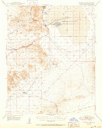
 1953 Trona1956 Print · USGSThe high desert of San Bernardino and Inyo counties during the early Cold War reveals a landscape of mineral industry and military expansion. You can trace the Old Spanish Trail, locate the Trona potash works, and find remote outposts like Ashford Mill.
 - 1957 Map of Trona, 1964 Print
 1957 Trona1964 Print · USGSThe High Desert in the mid-fifties is captured here as a landscape of remote mining outposts and growing military installations. Trace the industrial rail lines to Trona, the mining history of Randsburg, or the isolated expanse of the Naval Ordnance Test Station.5 unique versions available
End of results
Showing maps 1-3 of 3
Top cities near Argus
Frequently asked questions
- What are the different types of historical maps available for Argus?
- What is the oldest map of Argus?
- Where can I purchase historical maps of Argus for my home or office?
- Where can I download high-res historical maps of Argus?
- Are there historical topographic maps available for Argus?
- Is there historical aerial imagery available for Argus?
- Where are historical maps of Argus sourced from?