1970s Maps of Arrowhead Equestrian Estates, California
Explore 1 historic maps of Arrowhead Equestrian Estates from the 1970s. These maps offer a rare glimpse into what life looked like during the 1970s — showing old roads, neighborhoods, homes, and landmarks that have changed or disappeared over time.
Whether you're researching your family's past, planning a metal detecting trip, or studying how Arrowhead Equestrian Estates's landscape evolved across the 1970s, these high-resolution maps are a powerful tool for exploring the history of this region.
- Focus on a specific era: All maps on this page are from the 1970s, giving you a focused view of this time period.
- See what’s changed: Compare century-old streets, trails, and buildings to today's modern landscape using overlays and satellite layers.
- Research with precision: Use these maps for genealogy, historical research, land use analysis, or educational projects.
- View, download, or print: Maps are fully viewable online in high resolution, and can be downloaded or printed for your own records.
Start exploring Arrowhead Equestrian Estates's history through authentic maps from the 1970s. This is your window into the past.
Arrowhead Equestrian Estates, CA maps
(1)- 1971 Map of Lake Arrowhead, 1975 Print
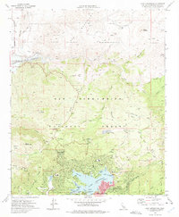 1971 Lake Arrowhead1975 Print · USGSLake Arrowhead and its surrounding national forest summits are captured here in the early seventies during a period of significant alpine development. Researchers can find old mountain enclaves like Deer Lodge Park alongside remote outposts such as Squints Ranch and Rock Camp Guard Station.3 unique versions available
End of results
Showing maps 1-1 of 1
Top cities near Arrowhead Equestrian Estates
- Fontana historical maps
- Victorville historical maps
- Rialto historical maps
- Hesperia historical maps
- Apple Valley historical maps
- Highland historical maps
See more
Frequently asked questions
- What are the different types of historical maps available for Arrowhead Equestrian Estates?
- What is the oldest map of Arrowhead Equestrian Estates?
- Where can I purchase historical maps of Arrowhead Equestrian Estates for my home or office?
- Where can I download high-res historical maps of Arrowhead Equestrian Estates?
- Are there historical topographic maps available for Arrowhead Equestrian Estates?
- Is there historical aerial imagery available for Arrowhead Equestrian Estates?
- Where are historical maps of Arrowhead Equestrian Estates sourced from?