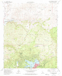
1971 Map of Lake Arrowhead
USGS Topo · Published 1975About this map
Lake Arrowhead serves as the centerpiece of this high-altitude community within the San Bernardino National Forest. The 1971 survey details a landscape of specialized lakeside development, featuring intricate inlets like Blue Jay Bay, Emerald Bay, and Rainbow Bay. The surrounding infrastructure reflects a mid-century period of established mountain living and recreation, with the Mountains Community Hospital, Lake Arrowhead Sch, and a private golf course serving the growing population at Deer Lodge Park and Cedar Glen.
Find a feature on this map
75 named features on this map. Tap any name to fly to it.
Don’t see what you’re looking for? This feature index may not catch every label — zoom into the map to look around manually.
Map Details
Editions of this 1971 Lake Arrowhead Map
3 editions found
Other maps of this area

1896 · San Bernardino
USGS Topo · 1:62,500

1898 · San Bernardino
USGS Topo · 1:62,500

1899 · Redlands
USGS Topo · 1:62,500

1901 · Southern California Sheet No. 1
USGS Topo · 1:250,000

1901 · San Bernardino
USGS Topo · 1:62,500

1901 · Redlands
USGS Topo · 1:62,500

1902 · Deep Creek
USGS Topo · 1:62,500

1902 · Hesperia
USGS Topo · 1:62,500

1904 · Southern California Sheet No. 1
USGS Topo · 1:250,000

1936 · Arrowhead
USGS Topo · 1:31,680