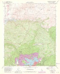
1971 Map of Lake Arrowhead
USGS Topo · Published 1981About this map
Lake Arrowhead and its complex shoreline dominate this 1970s landscape, illustrating the expansion of mountain communities within the San Bernardino National Forest. The map documents a moment of significant growth around the lake's many inlets, including North Bay, Blue Jay Bay, and Rainbow Bay. To the north, the terrain transitions into the high desert foothills of the Ord Mountains, where the Mojave River begins its descent.
Find a feature on this map
56 named features on this map. Tap any name to fly to it.
Don’t see what you’re looking for? This feature index may not catch every label — zoom into the map to look around manually.
Map Details
Editions of this 1971 Lake Arrowhead Map
3 editions found
Other maps of this area

1896 · San Bernardino
USGS Topo · 1:62,500

1898 · San Bernardino
USGS Topo · 1:62,500

1899 · Redlands
USGS Topo · 1:62,500

1901 · Southern California Sheet No. 1
USGS Topo · 1:250,000

1901 · San Bernardino
USGS Topo · 1:62,500

1901 · Redlands
USGS Topo · 1:62,500

1902 · Deep Creek
USGS Topo · 1:62,500

1902 · Hesperia
USGS Topo · 1:62,500

1904 · Southern California Sheet No. 1
USGS Topo · 1:250,000

1936 · Arrowhead
USGS Topo · 1:31,680