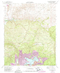
1971 Map of Lake Arrowhead
USGS Topo · Published 1988About this map
Lake Arrowhead serves as the centerpiece of this mountainous landscape within the San Bernardino National Forest. Revised in the late 1980s, the map documents the dense residential growth and recreational infrastructure surrounding the water, including the South Shore Marina, the Yacht Club, and the Mountains Community Hospital. To the north, the terrain shifts from the developed shores of North Shore toward the drainage of Deep Creek and the Mojave River Forks Reservoir, where a more utilitarian landscape of quarries and jeep trails replaces the resort docks.
Find a feature on this map
56 named features on this map. Tap any name to fly to it.
Don’t see what you’re looking for? This feature index may not catch every label — zoom into the map to look around manually.
Map Details
Editions of this 1971 Lake Arrowhead Map
3 editions found
Other maps of this area

1896 · San Bernardino
USGS Topo · 1:62,500

1898 · San Bernardino
USGS Topo · 1:62,500

1899 · Redlands
USGS Topo · 1:62,500

1901 · Southern California Sheet No. 1
USGS Topo · 1:250,000

1901 · San Bernardino
USGS Topo · 1:62,500

1901 · Redlands
USGS Topo · 1:62,500

1902 · Deep Creek
USGS Topo · 1:62,500

1902 · Hesperia
USGS Topo · 1:62,500

1904 · Southern California Sheet No. 1
USGS Topo · 1:250,000

1936 · Arrowhead
USGS Topo · 1:31,680