
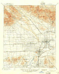
1898 Map of San Bernardino
USGS Topo · Published 1898About this map
The Santa Ana River valley serves as a bustling hub of late-nineteenth-century rail development, where the Southern California Ry. and the Southern Pacific R. R. converge near Colton. This survey captures the region during a pivotal era of agricultural expansion and mineral extraction, evidenced by the intricate network of the Gage Canal and the presence of a Quarry in the Jurupa Mountains.
Find a feature on this map
52 named features on this map. Tap any name to fly to it.
Don’t see what you’re looking for? This feature index may not catch every label — zoom into the map to look around manually.
Map Details
Editions of this 1898 San Bernardino Map
This is the sole edition of this map. No revisions or reprints were ever made.
Historical Maps of Riverside Through Time
12 maps found

1896 San Bernardino
San Bernardino County, CA
1898 San Bernardino
San Bernardino County, CA
1901 San Bernardino
San Bernardino County, CA

1942 San Bernardino
San Bernardino County, CA
1953 San Bernardino
San Bernardino County, CA
1954 San Bernardino
San Bernardino County, CA

1956 San Bernardino
San Bernardino County, CA

1957 San Bernardino
San Bernardino County, CA

1958 San Bernardino
San Bernardino County, CA

1959 San Bernardino
San Bernardino County, CA

1966 San Bernardino
San Bernardino County, CA

1982 San Bernardino
San Bernardino County, CA