1970s Maps of Big Bear Lake, California
Explore 4 historic maps of Big Bear Lake from the 1970s. These maps offer a rare glimpse into what life looked like during the 1970s — showing old roads, neighborhoods, homes, and landmarks that have changed or disappeared over time.
Whether you're researching your family's past, planning a metal detecting trip, or studying how Big Bear Lake's landscape evolved across the 1970s, these high-resolution maps are a powerful tool for exploring the history of this region.
- Focus on a specific era: All maps on this page are from the 1970s, giving you a focused view of this time period.
- See what’s changed: Compare century-old streets, trails, and buildings to today's modern landscape using overlays and satellite layers.
- Research with precision: Use these maps for genealogy, historical research, land use analysis, or educational projects.
- View, download, or print: Maps are fully viewable online in high resolution, and can be downloaded or printed for your own records.
Start exploring Big Bear Lake's history through authentic maps from the 1970s. This is your window into the past.
Big Bear Lake, CA maps
(4)- 1970 Map of Moonridge, 1975 Print
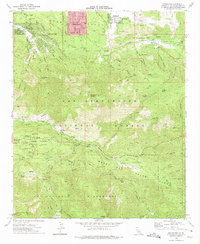 1970 Moonridge1975 Print · USGSSan Bernardino’s mountain communities and high-country camps are captured here during the early 1970s. Researchers can trace historic mountain retreats like University Camp and Promised Land Camp or locate the early footprint of the Gold Mine Ski Area.3 unique versions available
 - 1970 Map of Big Bear Lake, 1975 Print
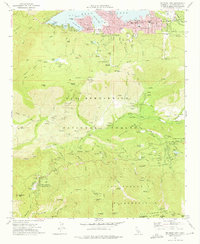 1970 Big Bear Lake1975 Print · USGSBig Bear Lake and the surrounding San Bernardino peaks are captured in the early 1970s, showcasing a landscape of mountain retreats and high-altitude camps. Researchers can trace historic sites like the Seven Oaks Resort, Camp Angelus, and the Glen Martin School.6 unique versions available
 - 1971 Map of Big Bear City, 1975 Print
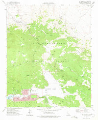 1971 Big Bear City1975 Print · USGSBig Bear City and the high desert transition are captured in the early 1970s as mining and recreation reshaped the San Bernardino Mountains. Genealogists and historians can trace the foundations of Doble, locate the Gold Hill Mine, and see the residential growth of Sugarloaf and Big Bear City.7 unique versions available
 - 1971 Map of Fawnskin, 1975 Print
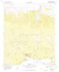 1971 Fawnskin1975 Print · USGSThe northern shore of Big Bear Lake comes alive in the early seventies, showcasing a landscape of high-altitude mining and mountain recreation. Genealogists and historians can locate the Belleville (Site), the Big Bear Solar Observatory, and the North Shore Sch.3 unique versions available
End of results
Showing maps 1-4 of 4
Top cities near Big Bear Lake
- Redlands historical maps
- Highland historical maps
- Yucaipa historical maps
- Banning historical maps
- Running Springs historical maps
Top neighborhoods of Big Bear Lake
Frequently asked questions
- What are the different types of historical maps available for Big Bear Lake?
- What is the oldest map of Big Bear Lake?
- Where can I purchase historical maps of Big Bear Lake for my home or office?
- Where can I download high-res historical maps of Big Bear Lake?
- Are there historical topographic maps available for Big Bear Lake?
- Is there historical aerial imagery available for Big Bear Lake?
- Where are historical maps of Big Bear Lake sourced from?