1970s Maps of Fizzben Heights, California
Explore 1 historic maps of Fizzben Heights from the 1970s. These maps offer a rare glimpse into what life looked like during the 1970s — showing old roads, neighborhoods, homes, and landmarks that have changed or disappeared over time.
Whether you're researching your family's past, planning a metal detecting trip, or studying how Fizzben Heights's landscape evolved across the 1970s, these high-resolution maps are a powerful tool for exploring the history of this region.
- Focus on a specific era: All maps on this page are from the 1970s, giving you a focused view of this time period.
- See what’s changed: Compare century-old streets, trails, and buildings to today's modern landscape using overlays and satellite layers.
- Research with precision: Use these maps for genealogy, historical research, land use analysis, or educational projects.
- View, download, or print: Maps are fully viewable online in high resolution, and can be downloaded or printed for your own records.
Start exploring Fizzben Heights's history through authentic maps from the 1970s. This is your window into the past.
Fizzben Heights, CA maps
(1)- 1971 Map of Fifteenmile Valley, 1975 Print
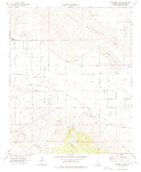 1971 Fifteenmile Valley1975 Print · USGSThe high desert of San Bernardino County comes into focus during the early seventies as residential grids begin to mesh with the local ranching and rail landscape. Genealogists and historians can trace old homestead routes and industrial markers like the V P Mine, Deadman Point, and the Atchison Topeka and Santa Fe Railway.2 unique versions available
End of results
Showing maps 1-1 of 1
Top cities near Fizzben Heights
- Victorville historical maps
- Hesperia historical maps
- Apple Valley historical maps
- Lake Arrowhead historical maps
- Big Bear Lake historical maps
- Running Springs historical maps
Frequently asked questions
- What are the different types of historical maps available for Fizzben Heights?
- What is the oldest map of Fizzben Heights?
- Where can I purchase historical maps of Fizzben Heights for my home or office?
- Where can I download high-res historical maps of Fizzben Heights?
- Are there historical topographic maps available for Fizzben Heights?
- Is there historical aerial imagery available for Fizzben Heights?
- Where are historical maps of Fizzben Heights sourced from?