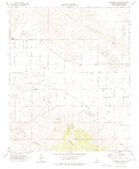
1971 Map of Fifteenmile Valley
USGS Topo · Published 1975About this map
The Granite Mountains dominate the northern landscape of this Mojave desert region, giving way to the broad alluvial plains of Apple Valley and Fifteenmile Valley. The Atchison Topeka and Santa Fe Railway cuts a prominent diagonal across the southern terrain, reflecting the area's role as a transportation corridor. Settlement patterns in the early 1970s are marked by a regular grid of desert roads like Milpas Rd and Soledad Rd, punctuated by family-named landmarks such as Miller Ranch Rd.
Find a feature on this map
50 named features on this map. Tap any name to fly to it.
Don’t see what you’re looking for? This feature index may not catch every label — zoom into the map to look around manually.
Map Details
Editions of this 1971 Fifteenmile Valley Map
2 editions found
Other maps of this area

1901 · Southern California Sheet No. 1
USGS Topo · 1:250,000

1902 · Deep Creek
USGS Topo · 1:62,500

1902 · San Gorgonio
USGS Topo · 1:125,000

1904 · Southern California Sheet No. 1
USGS Topo · 1:250,000

1932 · Barstow
USGS Topo · 1:125,000

1934 · Barstow
USGS Topo · 1:125,000

1947 · Lucerne Valley
USGS Topo · 1:62,500

1949 · Lucerne Valley
USGS Topo · 1:62,500

1953 · San Bernardino
USGS Topo · 1:250,000

1955 · Ord Mountains
USGS Topo · 1:62,500